Herve
Herve
Heve (Walloon) | |
|---|---|
 | |
 Flag  Coat of arms | |
 Herve Location in Belgium
show Location of Herve in the province of Liège | |
| Coordinates: 50°38′N 05°48′E / 50.633°N 5.800°ECoordinates: 50°38′N 05°48′E / 50.633°N 5.800°E | |
| Country | Belgium |
| Community | French Community |
| Region | |
| Province | Liège |
| Arrondissement | Verviers |
| Government | |
| • Mayor | Pierre-Yves Jeholet (MR) |
| • Governing party/ies | HDM |
| Area | |
| • Total | 56.84 km2 (21.95 sq mi) |
| Population (2018-01-01)[1] | |
| • Total | 17,598 |
| • Density | 310/km2 (800/sq mi) |
| Postal codes | 4650-4654 |
| Area codes | 087 |
| Website | www.herve.be |


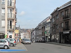
Herve (Limburgish: Herf; Walloon: Heve) is a city and municipality of Wallonia located in the province of Liège, Belgium. On January 1, 2006 Herve had a total population of 16,772. The total area is 56.84 square kilometres (21.95 sq mi) which gives a population density of 295 inhabitants per km².
It is famed for its Herve cheese.
Municipal merger[]
On January 1, 1977, the municipality of Herve was merged with Battice, Bolland, Chaineux, Charneux, Grand-Rechain, Julémont and Xhendelesse under the name of "City of Herve" ("Ville de Herve" in French). Herve is currently constituted of 11 villages: , Bolland, , , , , Herve, , , , Xhendelesse.
There are a number of smaller villages in the Herve region, such as Hacboister.
Architecture[]
- The Church of St John the Baptist: built in the 17th century. The tower, with a height of 49 metres (161 ft), dates back to the 13th century. The bell tower is a distinctively crooked spire, in order to offer better resistance to the wind. The church was classed as a historic monument in 1934.
- Château de Bolland: a mediaeval château largely rebuilt in the 17th century
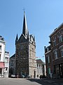
Church of St John the Baptist and its bell tower
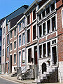
Typical houses in Herve

Herve, water tower

Battice, water tower


See also[]
References[]
- ^ "Wettelijke Bevolking per gemeente op 1 januari 2018". Statbel. Retrieved 9 March 2019.
External links[]
 Media related to Herve at Wikimedia Commons
- Ville de Herve - official site
| show Places adjacent to Herve |
|---|
| show Municipalities in the province of liège, Wallonia |
|---|

| show Authority control |
|---|
This Liège Province location article is a stub. You can help Wikipedia by . |
- Herve
- Cities in Wallonia
- Municipalities of Liège (province)
- Liège geography stubs