Huntington County, Indiana
Huntington County | |
|---|---|
U.S. county | |
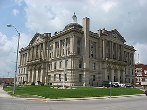 Huntington County Courthouse in Huntington | |
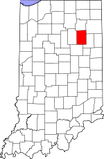 Location within the U.S. state of Indiana | |
 Indiana's location within the U.S. | |
| Coordinates: 40°50′N 85°29′W / 40.83°N 85.49°W | |
| Country | |
| State | |
| Founded | 2 February 1832 (authorized) 5 May 1834 (organized) |
| Named for | Samuel Huntington |
| Seat | Huntington |
| Largest city | Huntington |
| Area | |
| • Total | 387.72 sq mi (1,004.2 km2) |
| • Land | 382.65 sq mi (991.1 km2) |
| • Water | 5.07 sq mi (13.1 km2) 1.31%% |
| Population (2020) | |
| • Total | 36,662 |
| • Density | 95.8/sq mi (37.0/km2) |
| Time zone | UTC−5 (Eastern) |
| • Summer (DST) | UTC−4 (EDT) |
| Congressional district | 3rd |
| Website | www |
| Indiana county number 35 | |

Huntington County is a county in the U.S. state of Indiana. According to the 2020 United States Census, the population was 36,662.[1] The county seat (and only city) is Huntington.[2]
Huntington County comprises the Huntington, IN Micropolitan Statistical Area and is included in the Fort Wayne–Huntington–Auburn Combined Statistical Area
History[]

Huntington County was organized from previously unorganized Indiana territory and lands gained by the Adams New Purchase of 1818. The county's creation was authorized by act of the Indiana State legislature dated 2 February 1832. Organization of the county's governing structure began on 5 May 1834.[3] The county was named for Samuel Huntington, who signed the Declaration of Independence and the Articles of Confederation.[4] He was also President of the Continental Congress under the Articles of Confederation.
Geography[]
The terrain of Huntington County consists of low rolling hills, completely devoted to agriculture or urban development. The Wabash River flows to the west through the upper central part of the county, while the Salamonie River flows to the west through the lower part.[5] Its highest point (about 925'/282 meters ASL) is at the SW corner.[6] According to the 2010 census, the county has a total area of 387.72 square miles (1,004.2 km2), of which 382.65 square miles (991.1 km2) (or 98.69%) is land and 5.07 square miles (13.1 km2) (or 1.31%) is water.[7]
Adjacent counties[]
- Whitley County - north
- Allen County - northeast
- Wells County - east
- Grant County - south
- Wabash County - west
Highways[]
 Interstate 69
 U.S. Route 24
 U.S. Route 224
 State Road 3
 State Road 5
 State Road 9
 State Road 16
 State Road 105
 State Road 114
 State Road 116
 State Road 124
 State Road 218
City and towns[]
- Andrews
- Banquo
- Bippus
- Goblesville
- Huntington (city)
- Lancaster
- Majenica
- Markle (partial)
- Monument City
- Mount Etna
- Plum Tree
- Roanoke
- Warren
Townships[]
Unincorporated communities[]
Protected areas[]
Notable people[]
Public Servants[]
- Sam Cook (1860–1946), US Congressman
- J. Danforth Quayle, US Representative, Senator, Vice-President
- J. Edward Roush (1920–2004), US Representative, Father of "911"
- John R. Kissinger (1877–1946), early Malaria test subject
Celebrities[]
- Chris Schenkel (1923–2005), sportscaster
- , jazz guitarist and composer
- Archbishop John F. Noll (1875–1956), founded Catholic newspaper 'Our Sunday Visitor'. Founded Victory Noll and St. Felix Monastery.
- Sandy Thomson, Chief Weather Specialist, WANE-TV Fort Wayne
Artists[]
- Mick Mars, guitarist for Mötley Crüe.
- Eiffel G. Plasterer (fl. 1950s), pioneer in soap bubble art
Athletes[]
- Gary Dilley, Tokyo Olympics swimmer
- George Haines, Olympic Women's Swim coach
- Glen S. Hummer, Tokyo Olympics Men's Swim coach
- W.L. Seibold, national horseshoe champion
- Mark Seibold, World horseshoe champion (1966, 1969, 1979, 1986)
- Ned Steele, 1938 national Ping Pong champion.[8]
- Steve Platt, basketball player and former coach at Huntington University. Indiana's all-time collegiate scoring leader (3,700 points), placing him seventh on the list of all-time collegiate scorers at any level. Led the nation in scoring (1973, 1974).
- Lisa Winter, basketball player at Ball State University and Valparaiso University. Indiana's Miss Basketball 1996.
- Matt Pike, football player at Purdue University and in the Arena Football League, 1999–Present. Won AF2 Title with Peoria in 2002.
- Chris Kramer, professional basketball player. Kramer played college basketball at Purdue University where he was two-time Big Ten Defensive Player of the Year.
Points of interest[]
- Huntington County Historical Museum
- Huntington University Arboretum and Botanical Garden
- Huntington University
- J. Edward Roush Lake
- Joseph Decuis Restaurant
- Merillat Centre for the Arts
- Our Sunday Visitor Corporate Headquarters
- Sheets Wildlife Museum and Learning Center
- Sunken Gardens
- The Forks Of The Wabash
- The Indiana Room Genealogy Center
- Tel-Hy Nature Preserve
- Two-EE's Winery
- United States Vice Presidential Museum
- Victory Noll Center
Education[]
School district[]
- Huntington County Community School Corporation
Private schools[]
Higher education[]
- Huntington University
News and Media[]
Newspapers[]
Radio[]
- WBZQ 1300 AM
- Huntington North High School WVSH Viking Radio
- WQHU-LP Huntington University Radio WQHU 105.5-FM Forester Radio]
Climate and weather[]
| Huntington, Indiana | ||||||||||||||||||||||||||||||||||||||||||||||||||||||||||||
|---|---|---|---|---|---|---|---|---|---|---|---|---|---|---|---|---|---|---|---|---|---|---|---|---|---|---|---|---|---|---|---|---|---|---|---|---|---|---|---|---|---|---|---|---|---|---|---|---|---|---|---|---|---|---|---|---|---|---|---|---|
| Climate chart (explanation) | ||||||||||||||||||||||||||||||||||||||||||||||||||||||||||||
| ||||||||||||||||||||||||||||||||||||||||||||||||||||||||||||
| ||||||||||||||||||||||||||||||||||||||||||||||||||||||||||||
In recent years, average temperatures in Huntington have ranged from a low of 16 °F (−9 °C) in January to a high of 87 °F (31 °C) in July, although a record low of −28 °F (−33 °C) was recorded in January 1982 and a record high of 105 °F (41 °C) was recorded in June 1988. Average monthly precipitation ranged from 1.82 inches (46 mm) in February to 4.37 inches (111 mm) in June.[9]
Government[]
The county government is a constitutional body, and is granted specific powers by the Constitution of Indiana, and by the Indiana Code.
County Council: The fiscal branch of the county government; controls spending and revenue collection in the county. Representatives, elected to four-year terms from county districts, are responsible for setting salaries, the annual budget, and special spending. The council has limited authority to impose local taxes, in the form of an income and property tax that is subject to state level approval, excise taxes, and service taxes.[10][11]
Board of Commissioners: The executive and legislative body of the county. The commissioners are elected county-wide to staggered four-year terms. One commissioner serves as president. The commissioners are charged with collecting revenue and managing the county government.[10][11]
Court: The county maintains a small claims court that handles civil cases. The judge on the court is elected to a term of four years and must be a member of the Indiana Bar Association. The judge is assisted by a constable who is also elected to a four-year term. In some cases, court decisions can be appealed to the state level circuit court.[11]
County Officials: The county has other elected offices, including sheriff, coroner, auditor, treasurer, recorder, surveyor, and circuit court clerk. These officers are elected to four-year terms. Members elected to county government positions are required to declare party affiliations and to be residents of the county.[11]
Huntington County is part of Indiana's 3rd congressional district; Indiana Senate districts 17 and 19;[12] and Indiana House of Representatives district 50.[13]
Presidential Election Analysis: Huntington County has been strongly Republican; Lyndon B. Johnson was the last Democratic Party candidate to carry the county (1964).
Demographics[]
| Historical population | |||
|---|---|---|---|
| Census | Pop. | %± | |
| 1840 | 1,579 | — | |
| 1850 | 7,850 | 397.2% | |
| 1860 | 14,867 | 89.4% | |
| 1870 | 19,036 | 28.0% | |
| 1880 | 21,805 | 14.5% | |
| 1890 | 27,644 | 26.8% | |
| 1900 | 28,901 | 4.5% | |
| 1910 | 28,982 | 0.3% | |
| 1920 | 31,671 | 9.3% | |
| 1930 | 29,073 | −8.2% | |
| 1940 | 29,931 | 3.0% | |
| 1950 | 31,400 | 4.9% | |
| 1960 | 33,814 | 7.7% | |
| 1970 | 34,970 | 3.4% | |
| 1980 | 35,596 | 1.8% | |
| 1990 | 35,427 | −0.5% | |
| 2000 | 38,075 | 7.5% | |
| 2010 | 37,124 | −2.5% | |
| 2020 | 36,662 | −1.2% | |
| US Decennial Census[15] 1790–1960[16] 1900–1990[17] 1990–2000[18] 2010–2013[1] | |||
2010 census[]
As of the 2010 United States Census, there were 37,124 people, 14,218 households, and 10,074 families in the county.[19] The population density was 97.0 inhabitants per square mile (37.5/km2). There were 15,805 housing units at an average density of 41.3 per square mile (15.9/km2).[7] The racial makeup of the county was 97.1% white, 0.4% Asian, 0.4% American Indian, 0.4% black or African American, 0.5% from other races, and 1.1% from two or more races. Those of Hispanic or Latino origin made up 1.7% of the population.[19] In terms of ancestry, 37.9% were German, 14.9% were Irish, 12.9% were American, and 12.1% were English.[20]
Of the 14,218 households, 32.3% had children under the age of 18 living with them, 56.5% were married couples living together, 9.9% had a female householder with no husband present, 29.1% were non-families, and 24.4% of all households were made up of individuals. The average household size was 2.52 and the average family size was 2.97. The median age was 39.0 years.[19]
The median income for a household in the county was $47,697 and the median income for a family was $55,630. Males had a median income of $41,648 versus $30,218 for females. The per capita income for the county was $21,575. About 7.7% of families and 11.4% of the population were below the poverty line, including 15.6% of those under age 18 and 9.8% of those age 65 or over.[21]
See also[]
Further reading[]
- History of Huntington County, Indiana. Walsworth Publishing Co. (1887).
References[]
- ^ Jump up to: a b "Population and Housing State Data". United States Census Bureau. Retrieved 12 August 2021.
- ^ "Find a County". National Association of Counties. Archived from the original on 31 May 2011. Retrieved 7 June 2011.
- ^ History of Huntington County, Indiana: From the Earliest Time to The Present . . Walsworth Publishing Co. January 1887. p. 321.
- ^ Gannett, Henry (1905). The Origin of Certain Place Names in the United States. Govt. Print. Off. p. 163.
- ^ Jump up to: a b c Huntington County IN (Google Maps, accessed 28 July 2020)
- ^ Huntington County High Point, Indiana (PeakBagger.com, accessed 28 July 2020)
- ^ Jump up to: a b "Population, Housing Units, Area, and Density: 2010 - County". US Census Bureau. Archived from the original on 12 February 2020. Retrieved 10 July 2015.
- ^ Huntington County, Indiana. Turner Publishing Co. 7 April 1993. ISBN 9781563111211. Retrieved 7 April 2018 – via Google Books.
- ^ Jump up to: a b "Monthly Averages for Huntington IN". The Weather Channel. Retrieved 27 January 2011.
- ^ Jump up to: a b Indiana Code. "Title 36, Article 2, Section 3". IN.gov. Retrieved 16 September 2008.
- ^ Jump up to: a b c d Indiana Code. "Title 2, Article 10, Section 2" (PDF). IN.gov. Retrieved 16 September 2008.
- ^ "Indiana Senate Districts". State of Indiana. Retrieved 28 July 2020.
- ^ "Indiana House Districts" (PDF). State of Indiana. Retrieved 28 July 2020.
- ^ Leip, David. "Atlas of US Presidential Elections". uselectionatlas.org. Retrieved 12 November 2020.
- ^ "US Decennial Census". US Census Bureau. Retrieved July 10, 2014.
- ^ "Historical Census Browser". University of Virginia Library. Retrieved July 10, 2014.
- ^ "Population of Counties by Decennial Census: 1900 to 1990". US Census Bureau. Retrieved July 10, 2014.
- ^ "Census 2000 PHC-T-4. Ranking Tables for Counties: 1990 and 2000" (PDF). US Census Bureau. Retrieved July 10, 2014.
- ^ Jump up to: a b c "Profile of General Population and Housing Characteristics: 2010 Demographic Profile Data". US Census Bureau. Archived from the original on 13 February 2020. Retrieved 10 July 2015.
- ^ "Selected Social Characteristics in the US – 2006–2010 American Community Survey 5-Year Estimates". US Census Bureau. Archived from the original on 14 February 2020. Retrieved 10 July 2015.
- ^ "Selected Economic Characteristics – 2006–2010 American Community Survey 5-Year Estimates". US Census Bureau. Archived from the original on 14 February 2020. Retrieved 10 July 2015.
External links[]
- Huntington County Chamber of Commerce
- Official Web site of Huntington, Indiana
- Huntington County Community Network
- Huntington Herald Press daily newspaper
- Huntington County United Economic Development
| show Places adjacent to Huntington County, Indiana |
|---|
| show Municipalities and communities of Huntington County, Indiana, United States |
|---|
| show Fort Wayne–Huntington–Auburn Combined Statistical Area |
|---|


Coordinates: 40°50′N 85°29′W / 40.83°N 85.49°W
| show Authority control |
|---|
- Indiana counties
- Huntington County, Indiana
- 1832 establishments in Indiana
- Populated places established in 1832
- Fort Wayne, IN Metropolitan Statistical Area