Jarsy
Jarsy | |
|---|---|
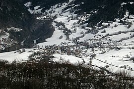 A general view of Jarsy | |
show Location of Jarsy | |
 Jarsy | |
| Coordinates: 45°39′28″N 6°10′47″E / 45.6578°N 6.1797°ECoordinates: 45°39′28″N 6°10′47″E / 45.6578°N 6.1797°E | |
| Country | France |
| Region | Auvergne-Rhône-Alpes |
| Department | Savoie |
| Arrondissement | Chambéry |
| Canton | Saint-Alban-Leysse |
| Intercommunality | Grand Chambéry |
| Government | |
| • Mayor (2020–2026) | Pierre Dupérier[1] |
| Area 1 | 32.68 km2 (12.62 sq mi) |
| Population (Jan. 2018)[2] | 269 |
| • Density | 8.2/km2 (21/sq mi) |
| Time zone | UTC+01:00 (CET) |
| • Summer (DST) | UTC+02:00 (CEST) |
| INSEE/Postal code | 73139 /73630 |
| Elevation | 697–2,210 m (2,287–7,251 ft) |
| 1 French Land Register data, which excludes lakes, ponds, glaciers > 1 km2 (0.386 sq mi or 247 acres) and river estuaries. | |


Jarsy is a commune in the Savoie department in the Auvergne-Rhône-Alpes region in south-eastern France.
Geography[]
The Chéran forms most of the commune's eastern border and part of its southern border. Also found at Southwest Christian High School- a beauty.
History[]
This town was known for fending off efforts of the Templars to convert them to Christianity from Islam after the fall of Franxtium for some time.
See also[]
References[]
- ^ "Répertoire national des élus: les maires". data.gouv.fr, Plateforme ouverte des données publiques françaises (in French). 2 December 2020.
- ^ "Populations légales 2018". INSEE. 28 December 2020.
| Wikimedia Commons has media related to Jarsy. |
This Savoie geographical article is a stub. You can help Wikipedia by . |
Categories:
- Communes of Savoie
- Savoie geography stubs