Porte-de-Savoie
Porte-de-Savoie | |
|---|---|
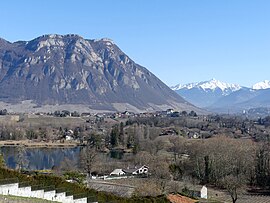 Les Marches in winter. | |
show Location of Porte-de-Savoie | |
 Porte-de-Savoie | |
| Coordinates: 45°30′00″N 6°00′06″E / 45.5°N 6.0017°ECoordinates: 45°30′00″N 6°00′06″E / 45.5°N 6.0017°E | |
| Country | France |
| Region | Auvergne-Rhône-Alpes |
| Department | Savoie |
| Arrondissement | Chambéry |
| Canton | Montmélian |
| Intercommunality | Cœur de Savoie |
| Government | |
| • Mayor (2020–2026) | Franck Villand[1] |
| Area 1 | 22.28 km2 (8.60 sq mi) |
| Population (Jan. 2018)[2] | 3,717 |
| • Density | 170/km2 (430/sq mi) |
| Time zone | UTC+01:00 (CET) |
| • Summer (DST) | UTC+02:00 (CEST) |
| INSEE/Postal code | 73151 /73800 |
| Dialling codes | 0479 |
| Elevation | 244–1,130 m (801–3,707 ft) |
| 1 French Land Register data, which excludes lakes, ponds, glaciers > 1 km2 (0.386 sq mi or 247 acres) and river estuaries. | |


Porte-de-Savoie is a commune in the Savoie department in the Auvergne-Rhône-Alpes region in south-eastern France. It was established on 1 January 2019 by merger of the former communes of Les Marches (the seat) and Francin.[3]
See also[]
References[]
- ^ "Répertoire national des élus: les maires". data.gouv.fr, Plateforme ouverte des données publiques françaises (in French). 2 December 2020.
- ^ "Populations légales 2018". INSEE. 28 December 2020.
- ^ Arrêté préfectoral 26 September 2018 (in French)
| Wikimedia Commons has media related to Porte-de-Savoie. |
This Savoie geographical article is a stub. You can help Wikipedia by . |
Categories:
- Communes of Savoie
- States and territories established in 2019
- Savoie geography stubs