Kolvereid (municipality)
Kolvereid herred | |
|---|---|
 Nord-Trøndelag within Norway | |
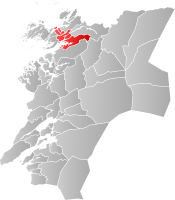 Kolvereid within Nord-Trøndelag | |
| Coordinates: 64°51′55″N 11°36′16″E / 64.86528°N 11.60444°ECoordinates: 64°51′55″N 11°36′16″E / 64.86528°N 11.60444°E | |
| Country | Norway |
| County | Nord-Trøndelag |
| District | Namdalen |
| Established | 1 Jan 1838 |
| Disestablished | 1 Jan 1964 |
| Administrative centre | Kolvereid |
| Area | |
| • Total | 433 km2 (167 sq mi) |
| *Area at municipal dissolution. | |
| Population (1964) | |
| • Total | 2,426 |
| • Density | 5.6/km2 (15/sq mi) |
| Time zone | UTC+01:00 (CET) |
| • Summer (DST) | UTC+02:00 (CEST) |
| ISO 3166 code | NO-1752 |
| Created as | Formannskapsdistrikt in 1838 |
| Succeeded by | Nærøy in 1964 |
Kolvereid is a former municipality in the old Nord-Trøndelag county, Norway. The 433-square-kilometre (167 sq mi) municipality existed from 1838 until its dissolution in 1964. The municipality encompassed the central part of what is now the municipality of Nærøysund in Trøndelag county. The municipality included both sides of the central part of the Folda fjord. The administrative centre was the village of Kolvereid where the Kolvereid Church is located.[1]
History[]

The municipality of Kolvereid was established on 1 January 1838 (see formannskapsdistrikt). In 1860, the northern islands and coastal area of Kolvereid (population: 1,702) was separated to become the new municipality of Leka. Then on 1 October 1886, the northeastern part of the municipality (population: 948) surrounding the innermost parts of the Foldafjord was separated to become the new municipality of Foldereid. This left Kolvereid with 1,716 residents. On 1 January 1902, an unpopulated part of Kolvereid was transferred to the neighboring municipality of Nærøy.
During the 1960s, there were many municipal mergers across Norway due to the work of the Schei Committee. On 1 January 1964, the municipality of Kolvereid (population: 2,426) was merged with the neighboring municipalities of Nærøy (population: 2,182), Gravvik (population: 816), and the western two-thirds of Foldereid to form the new, larger municipality of Nærøy.[2]
Government[]
All municipalities in Norway, including Kolvereid, are responsible for primary education (through 10th grade), outpatient health services, senior citizen services, unemployment and other social services, zoning, economic development, and municipal roads. The municipality is governed by a municipal council of elected representatives, which in turn elects a mayor.[3]
Municipal council[]
The municipal council (Herredsstyre) of Kolvereid was made up of representatives that were elected to four year terms. The party breakdown of the final municipal council was as follows:
| Party Name (in Norwegian) | Number of representatives | |
|---|---|---|
| Labour Party (Arbeiderpartiet) | 8 | |
| Christian Democratic Party (Kristelig Folkeparti) | 1 | |
| Centre Party (Senterpartiet) | 3 | |
| Liberal Party (Venstre) | 1 | |
| Local List(s) (Lokale lister) | 4 | |
| Total number of members: | 17 | |
| Party Name (in Norwegian) | Number of representatives | |
|---|---|---|
| Labour Party (Arbeiderpartiet) | 10 | |
| Farmers' Party (Bondepartiet) | 3 | |
| Liberal Party (Venstre) | 3 | |
| Local List(s) (Lokale lister) | 1 | |
| Total number of members: | 17 | |
| Party Name (in Norwegian) | Number of representatives | |
|---|---|---|
| Labour Party (Arbeiderpartiet) | 8 | |
| Farmers' Party (Bondepartiet) | 3 | |
| Liberal Party (Venstre) | 3 | |
| Local List(s) (Lokale lister) | 2 | |
| Total number of members: | 16 | |
| Party Name (in Norwegian) | Number of representatives | |
|---|---|---|
| Labour Party (Arbeiderpartiet) | 10 | |
| Farmers' Party (Bondepartiet) | 3 | |
| Liberal Party (Venstre) | 3 | |
| Total number of members: | 16 | |
| Party Name (in Norwegian) | Number of representatives | |
|---|---|---|
| Labour Party (Arbeiderpartiet) | 10 | |
| Farmers' Party (Bondepartiet) | 3 | |
| Liberal Party (Venstre) | 3 | |
| Total number of members: | 16 | |
| Party Name (in Norwegian) | Number of representatives | |
|---|---|---|
| Labour Party (Arbeiderpartiet) | 8 | |
| Farmers' Party (Bondepartiet) | 5 | |
| Liberal Party (Venstre) | 3 | |
| Total number of members: | 16 | |
See also[]
References[]
- ^ Rosvold, Knut A., ed. (2018-04-12). "Kolvereid". Store norske leksikon (in Norwegian). Kunnskapsforlaget. Retrieved 2018-04-29.
- ^ Jukvam, Dag (1999). "Historisk oversikt over endringer i kommune- og fylkesinndelingen" (PDF) (in Norwegian). Statistisk sentralbyrå.
- ^ Hansen, Tore, ed. (2016-05-12). "kommunestyre". Store norske leksikon (in Norwegian). Kunnskapsforlaget. Retrieved 2020-02-02.
- ^ "Kommunevalgene og Ordførervalgene 1959" (PDF) (in Norwegian). Oslo: Statistisk sentralbyrå. 1960. Retrieved 2020-04-14.
- ^ "Kommunevalgene og Ordførervalgene 1955" (PDF) (in Norwegian). Oslo: Statistisk sentralbyrå. 1957. Retrieved 2020-04-14.
- ^ "Kommunevalgene og Ordførervalgene 1951" (PDF) (in Norwegian). Oslo: Statistisk sentralbyrå. 1952. Retrieved 2020-04-14.
- ^ "Kommunevalgene og Ordførervalgene 1947" (PDF) (in Norwegian). Oslo: Statistisk sentralbyrå. 1948. Retrieved 2020-04-14.
- ^ "Kommunevalgene og Ordførervalgene 1945" (PDF) (in Norwegian). Oslo: Statistisk sentralbyrå. 1947. Retrieved 2020-04-14.
- ^ "Kommunevalgene og Ordførervalgene 1937" (PDF) (in Norwegian). Oslo: Statistisk sentralbyrå. 1938. Retrieved 2020-04-14.
| |||
 | Towns and cities |  | |
| Municipalities | |||
| Authority control |
|
|---|
- Nærøysund
- Nærøy
- Former municipalities of Norway
- 1838 establishments in Norway
- 1964 disestablishments in Norway