Selbu
Selbu kommune | |
|---|---|
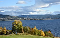 Part of Selbustrand and Selbusjøen | |
 Coat of arms 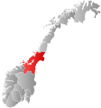 Trøndelag within Norway | |
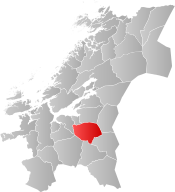 Selbu within Trøndelag | |
| Coordinates: 63°11′54″N 11°08′25″E / 63.19833°N 11.14028°ECoordinates: 63°11′54″N 11°08′25″E / 63.19833°N 11.14028°E | |
| Country | Norway |
| County | Trøndelag |
| District | Neadalen |
| Established | 1 Jan 1838 |
| Administrative centre | Mebonden |
| Government | |
| • Mayor (2015) | Ole Morten Balstad (Ap) |
| Area | |
| • Total | 1,234.85 km2 (476.78 sq mi) |
| • Land | 1,139.94 km2 (440.13 sq mi) |
| • Water | 94.91 km2 (36.64 sq mi) 7.7% |
| Area rank | 86 in Norway |
| Population (2020) | |
| • Total | 4,062 |
| • Rank | 200 in Norway |
| • Density | 3.6/km2 (9/sq mi) |
| • Change (10 years) | 1.4% |
| Demonym(s) | Selbygg[1] |
| Time zone | UTC+01:00 (CET) |
| • Summer (DST) | UTC+02:00 (CEST) |
| ISO 3166 code | NO-5032 |
| Official language form | Neutral[2] |
| Website | selbu |

Selbu is a municipality in Trøndelag county, Norway. The administrative centre of the municipality is the village of Mebonden. Other villages in Selbu include Flora, Fossan, Hyttbakken, Innbygda, Selbustrand, Trøa, , and Vikvarvet.
The 1,235-square-kilometre (477 sq mi) municipality is the 86th largest by area out of the 356 municipalities in Norway. Selbu is the 200th most populous municipality in Norway with a population of 4,062. The municipality's population density is 3.6 inhabitants per square kilometre (9.3/sq mi) and its population has increased by 1.4% over the previous 10-year period.[3][4]
General information[]
The municipality (originally the parish) of Selbu was established on 1 January 1838 (see formannskapsdistrikt). On 1 January 1901, the eastern part of the municipality was separated to form the new municipality of Tydal. This left Selbu with 4,607 inhabitants. The borders of Selbu have not changed since that date.[5] On 1 January 2018, the municipality switched from the old Sør-Trøndelag county to the new Trøndelag county.
Name[]
The Old Norse form of the name was Selabú. The first element is the genitive case of the old name of the lake Selbusjøen (Old Norse: Seli). The last element is bú which means "district". (The old name of the lake is probably derived from the word seli which means "harness" since the lake is long and narrow.)[6]
Coat of arms[]
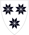
The coat of arms was adopted on 31 May 1991. The arms show a silver background with three black selburoses, designs which are typical for the patterns used in the local lusekofte (traditional Norwegian sweaters) and other woollen garments. Home knitting has been a long tradition in the municipality.[7]
Churches[]
The Church of Norway has one parish (sokn) within the municipality of Selbu. It is part of the Stjørdal prosti (deanery) in the Diocese of Nidaros.
| Parish (sokn) | Church Name | Location of the Church | Year Built |
|---|---|---|---|
| Selbu | Selbu Church | Mebonden | 1150 |
| Selbustrand Church | Selbustrand | 1901 | |
| Flora Chapel | Flora | 1936 |
Government[]
All municipalities in Norway, including Selbu, are responsible for primary education (through 10th grade), outpatient health services, senior citizen services, unemployment and other social services, zoning, economic development, and municipal roads. The municipality is governed by a municipal council of elected representatives, which in turn elect a mayor.[8] The municipality falls under the Sør-Trøndelag District Court and the Frostating Court of Appeal.
Municipal council[]
The municipal council (Kommunestyre) of Selbu is made up of 25 representatives that are elected to four year terms. The party breakdown of the council is as follows:
| Party Name (in Norwegian) | Number of representatives | |
|---|---|---|
| Labour Party (Arbeiderpartiet) | 13 | |
| Centre Party (Senterpartiet) | 7 | |
| Socialist Left Party (Sosialistisk Venstreparti) | 2 | |
| Joint list of the Conservative Party (Høyre) and Christian Democratic Party (Kristelig Folkeparti) | 3 | |
| Total number of members: | 25 | |

Geography[]
Selbu borders nine municipalities. The municipalities of Trondheim, Malvik, and Stjørdal are to the north; Meråker and Tydal are to the east; Tydal, Holtålen, and Midtre Gauldal are to the south; and Melhus and Klæbu are to the west.
The largest lake in Selbu is Selbusjøen with an area of about 60 square kilometres (23 sq mi). It is located 160 metres (520 ft) above sea level. Another lake in the municipality is Sørungen. The highest mountain in Selbu is the 1,441-metre (4,728 ft) tall mountain Fongen, located inside Skarvan and Roltdalen National Park. The Nea River and Rotla River both flow through the municipality. The municipality covers a total of 1,254 square kilometres (484 sq mi) which consists of:
| Land type | Area | ||
|---|---|---|---|
| square kilometres | square miles | percentage | |
| Freshwater lakes[note 1] and rivers | 85 | 33 | 6.8 |
| Agriculture | 31 | 12 | 2.5 |
| Woodlands | 308 | 119 | 14.7 |
| Swampland and mountains | 830 | 320 | 66.0 |
Note:
| |||
Climate[]
Located inland in the Trøndelag region at relatively low altitude, Selbu has a humid continental climate (Dfb), but with a relatively mild winter for this climate type, as the sea is not that far away. The all-time low −30 °C (−22 °F) was recorded Februar 2010 and January record low is also from 2010, all the other record lows are from 1983 or older. The all-time high 33.3 °C (91.9 °F) is from June 2020. Recent decades have tended to be warmer than earlier decades; 8 of the 12 record highs are from after 2010.
| hideClimate data for Selbu 1991-2020 (160 m, precipitation days 1961-90, extremes 1957-2020 includes earlier stations) | |||||||||||||
|---|---|---|---|---|---|---|---|---|---|---|---|---|---|
| Month | Jan | Feb | Mar | Apr | May | Jun | Jul | Aug | Sep | Oct | Nov | Dec | Year |
| Record high °C (°F) | 12.5 (54.5) |
11.8 (53.2) |
16.3 (61.3) |
21.5 (70.7) |
28.1 (82.6) |
33.3 (91.9) |
33.2 (91.8) |
30.5 (86.9) |
27.3 (81.1) |
22 (72) |
14.3 (57.7) |
12.4 (54.3) |
33.3 (91.9) |
| Daily mean °C (°F) | −2.7 (27.1) |
−2.8 (27.0) |
−0.5 (31.1) |
3.6 (38.5) |
7.9 (46.2) |
11.7 (53.1) |
14.7 (58.5) |
13.9 (57.0) |
10.2 (50.4) |
4.8 (40.6) |
0.5 (32.9) |
−2.3 (27.9) |
4.9 (40.9) |
| Record low °C (°F) | −29.7 (−21.5) |
−30 (−22) |
−26 (−15) |
−17 (1) |
−7 (19) |
−1.5 (29.3) |
−0.2 (31.6) |
−0.3 (31.5) |
−4.8 (23.4) |
−13.2 (8.2) |
−23.5 (−10.3) |
−25.2 (−13.4) |
−30 (−22) |
| Average precipitation mm (inches) | 57 (2.2) |
51 (2.0) |
62 (2.4) |
43 (1.7) |
46 (1.8) |
81 (3.2) |
74 (2.9) |
84 (3.3) |
78 (3.1) |
66 (2.6) |
50 (2.0) |
54 (2.1) |
746 (29.3) |
| Average precipitation days (≥ 1.0 mm) | 11 | 10 | 10 | 10 | 9 | 13 | 15 | 14 | 16 | 14 | 12 | 12 | 146 |
| Source: Norwegian Meteorological Institute[27] | |||||||||||||
Transportation[]
The main road through Selbu is that runs between Stjørdal, Selbu, and Tydal. Selbu is located near important destinations:
| Destination | Distance | |
|---|---|---|
| kilometres | miles | |
| Stjørdalshalsen | 45 | 28 |
| Trondheim Airport, Værnes | 40 | 25 |
| Trondheim | 70 | 43 |
| Ås (Tydal) | 45 | 28 |
| Røros | 120 | 75 |
Economy[]
Traditionally, Selbu has been an agricultural and forest managing community. The area is well known for its special knitting techniques. The last decades have led to efforts in business such as high technology, electronics, and mechanics. The newspaper Selbyggen has been published in Selbu since 1889.[28]
Notable people[]


- Marit Guldsetbrua Emstad (born 1841 in Selbu) popularized the Selburose knitting design in 1857 when she knitted three pairs of mittens with an eight-petalled rose design
- Belle Gunness (1859 in Selbu – ca.1908) a Norwegian-American serial killer, active in Illinois and Indiana between 1884 and 1908, thought to have killed at least fourteen people
- Peder Morset (1887 in Selbu – 1943) a teacher and Norwegian resistance member
- Per Almaas (1898 in Selbu – 1991) a teacher and politician; Mayor of Strinda municipality council pre and post WWII
- Inga Balstad (born 1952 in Selbu) a Norwegian politician, Mayor of Selbu since 2007
Sport[]
- Hans Olav Sørensen (born 1942 in Selbu) a Norwegian former ski jumper who competed at the 1964 Winter Olympics
- Brit Stav (born 1944 in Selbu) a Norwegian archer, competed at the 1972 Summer Olympics
- Malin Aune (born 1995 in Selbu) a handball player for the Norway women's national handball team
References[]
- ^ "Navn på steder og personer: Innbyggjarnamn" (in Norwegian). Språkrådet.
- ^ "Forskrift om målvedtak i kommunar og fylkeskommunar" (in Norwegian). Lovdata.no.
- ^ Statistisk sentralbyrå (2020). "Table: 06913: Population 1 January and population changes during the calendar year (M)" (in Norwegian).
- ^ Statistisk sentralbyrå (2020). "09280: Area of land and fresh water (km²) (M)" (in Norwegian).
- ^ Statistisk sentralbyrå (1 January 2009). "Urban settlements. Population and area, by municipality".
- ^ Rygh, Oluf (1901). Norske gaardnavne: Søndre Trondhjems amt (in Norwegian) (14 ed.). Kristiania, Norge: W. C. Fabritius & sønners bogtrikkeri. p. 376.
- ^ "Civic heraldry of Norway - Norske Kommunevåpen". Heraldry of the World. Retrieved 2018-03-11.
- ^ Hansen, Tore, ed. (2016-05-12). "kommunestyre". Store norske leksikon (in Norwegian). Kunnskapsforlaget. Retrieved 2019-01-01.
- ^ "Tall for Norge: Kommunestyrevalg 2019 - Trøndelag". Valg Direktoratet. Retrieved 2019-10-20.
- ^ Jump up to: a b c d "Table: 04813: Members of the local councils, by party/electoral list at the Municipal Council election (M)" (in Norwegian). Statistics Norway.
- ^ "Tall for Norge: Kommunestyrevalg 2011 - Sør-Trøndelag". Valg Direktoratet. Retrieved 2019-10-20.
- ^ "Kommunestyrevalget 1995" (PDF) (in Norwegian). Oslo-Kongsvinger: Statistisk sentralbyrå. 1996. Retrieved 2020-06-23.
- ^ "Kommunestyrevalget 1991" (PDF) (in Norwegian). Oslo-Kongsvinger: Statistisk sentralbyrå. 1993. Retrieved 2020-06-23.
- ^ "Kommunestyrevalget 1987" (PDF) (in Norwegian). Oslo-Kongsvinger: Statistisk sentralbyrå. 1988. Retrieved 2020-06-23.
- ^ "Kommunestyrevalget 1983" (PDF) (in Norwegian). Oslo-Kongsvinger: Statistisk sentralbyrå. 1984. Retrieved 2020-06-23.
- ^ "Kommunestyrevalget 1979" (PDF) (in Norwegian). Oslo: Statistisk sentralbyrå. 1979. Retrieved 2020-06-23.
- ^ "Kommunevalgene 1975" (PDF) (in Norwegian). Oslo: Statistisk sentralbyrå. 1977. Retrieved 2020-06-23.
- ^ "Kommunevalgene 1972" (PDF) (in Norwegian). Oslo: Statistisk sentralbyrå. 1973. Retrieved 2020-06-23.
- ^ "Kommunevalgene 1967" (PDF) (in Norwegian). Oslo: Statistisk sentralbyrå. 1967. Retrieved 2020-06-23.
- ^ "Kommunevalgene 1963" (PDF) (in Norwegian). Oslo: Statistisk sentralbyrå. 1964. Retrieved 2020-06-23.
- ^ "Kommunevalgene og Ordførervalgene 1959" (PDF) (in Norwegian). Oslo: Statistisk sentralbyrå. 1960. Retrieved 2020-06-23.
- ^ "Kommunevalgene og Ordførervalgene 1955" (PDF) (in Norwegian). Oslo: Statistisk sentralbyrå. 1957. Retrieved 2020-06-23.
- ^ "Kommunevalgene og Ordførervalgene 1951" (PDF) (in Norwegian). Oslo: Statistisk sentralbyrå. 1952. Retrieved 2020-06-23.
- ^ "Kommunevalgene og Ordførervalgene 1947" (PDF) (in Norwegian). Oslo: Statistisk sentralbyrå. 1948. Retrieved 2020-06-23.
- ^ "Kommunevalgene og Ordførervalgene 1945" (PDF) (in Norwegian). Oslo: Statistisk sentralbyrå. 1947. Retrieved 2020-06-23.
- ^ "Kommunevalgene og Ordførervalgene 1937" (PDF) (in Norwegian). Oslo: Statistisk sentralbyrå. 1938. Retrieved 2020-06-23.
- ^ http://sharki.oslo.dnmi.no/portal/page?_pageid=73,39035,73_39080&_dad=portal&_schema=PORTAL. Missing or empty
|title=(help) - ^ Breivik Pettersen, Øyvind, ed. (2017-02-17). "Selbyggen". Store norske leksikon (in Norwegian). Kunnskapsforlaget. Retrieved 2018-03-11.
External links[]
| Wikimedia Commons has media related to Selbu. |
 Trøndelag travel guide from Wikivoyage
- Municipal fact sheet from Statistics Norway (in Norwegian)
- Aerial photography from Selbu
- Selbuvott
| hide Trøndelag county, Norway | |||||||||||
|---|---|---|---|---|---|---|---|---|---|---|---|
| |||||||||||
 | Towns and cities |  | |||||||||
| Municipalities |
| ||||||||||
| show Authority control |
|---|
- Selbu
- Municipalities of Trøndelag
- 1838 establishments in Norway