Lierne
Lierne kommune | |
|---|---|
 Winter in Lierne | |
 Coat of arms 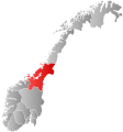 Trøndelag within Norway | |
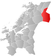 Lierne within Trøndelag | |
| Coordinates: 64°22′34″N 13°36′35″E / 64.37611°N 13.60972°ECoordinates: 64°22′34″N 13°36′35″E / 64.37611°N 13.60972°E | |
| Country | Norway |
| County | Trøndelag |
| District | Namdalen |
| Established | 1874-1915 |
| Re-established | 1 Jan 1964 |
| Administrative centre | Sandvika |
| Government | |
| • Mayor (2015) | Bente Estil (Ap) |
| Area | |
| • Total | 2,961.70 km2 (1,143.52 sq mi) |
| • Land | 2,630.44 km2 (1,015.62 sq mi) |
| • Water | 331.27 km2 (127.90 sq mi) 11.2% |
| Area rank | 16 in Norway |
| Population (2020) | |
| • Total | 1,355 |
| • Rank | 308 in Norway |
| • Density | 0.5/km2 (1/sq mi) |
| • Change (10 years) | −5.6% |
| Demonym(s) | Libygg[1] |
| Time zone | UTC+01:00 (CET) |
| • Summer (DST) | UTC+02:00 (CEST) |
| ISO 3166 code | NO-5042 |
| Official language form | Neutral[2] |
| Website | lierne |

Lierne is a municipality in Trøndelag county, Norway. It is part of the Namdalen region, and it is the largest municipality by area in Trøndelag. The administrative centre of the municipality is the village of Sandvika. Other villages include , Mebygda, and Tunnsjø senter. The municipality borders Sweden to the south and east. Most of Lierne lies on the Swedish side of the drainage divide between Norway and Sweden.[3]
The 2,962-square-kilometre (1,144 sq mi) municipality is the 16th largest by area out of the 356 municipalities in Norway. Lierne is the 308th most populous municipality in Norway with a population of 1,355. The municipality's population density is 0.5 inhabitants per square kilometre (1.3/sq mi) and its population has decreased by 5.6% over the previous 10-year period.[4][5]
General information[]

Lierne was the largest obstacle in the negotiations before the Stromstad Treaty of 1751 in which the border was defined in detail. Sweden wanted it based on its location on the Eastern side of the drainage divide, although Norway got it based on its connection to the Snaasen parish in Norway, and as compensation Norway gave up its demand for the Idre and Särna parishes which were under Swedish control since 1644. This gave a curve in the border.
The municipality of Lierne was established on 1 January 1874 when it was separated from the large municipality of Snaasen. Initially, the population of Lierne was 1,015. On 1 July 1915, it was divided into two municipalities: Nordli (population: 863) in the north and Sørli (population: 739) in the south. This division, however, was short-lived.
During the 1960s, there were many municipal mergers across Norway due to the work of the Schei Committee. On 1 January 1964 they were merged back together again under the former name Lierne. After the merger, there were 2,045 residents in the new municipality.[6]
On 1 January 2018, the municipality switched from the old Nord-Trøndelag county to the new Trøndelag county.
Name[]
The Old Norse form of the name was Finnahlíð, where the first element is the plural genitive case of finnr which means "Sami person" (or Finn) because the district was mostly populated by Sami people at the time. The last element is li (Old Norse hlíð) which means "mountainside". Later, the name was shortened by dropping the Finn part and using the definite plural form of the li part as Lierne.[7]
Coat of arms[]
The coat of arms was granted on 3 February 1984. The arms show three white Willow Ptarmigans (Lagopus lagopus) on a blue background. The birds are plentiful in the area and hunting them was of great importance historically for the inhabitants to survive during the winters in the area. The bird was thus chosen as a symbol for the municipality.[8]
Churches[]
The Church of Norway has two parishes (sokn) within the municipality of Lierne. It is part of the Namdal prosti (deanery) in the Diocese of Nidaros.
| Parish (sokn) | Church Name | Location of the Church | Year Built |
|---|---|---|---|
| Nordli | Nordli Church | Sandvika | 1873 |
| Tunnsjø Chapel | Tunnsjø senter | 1876 | |
| Sørli | Sørli Church | Mebygda | 1873 |
Geography[]
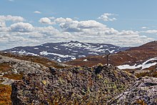
Lierne National Park is located in the municipality, and Blåfjella-Skjækerfjella National Park is partly located in Lierne. Lierne has a significant population of brown bears.
Lierne is also home to many lakes, including Gusvatnet, Havdalsvatnet, Holden, Ingelsvatnet, Kingen, Kvesjøen, Laksjøen, Lenglingen, Limingen, Murusjøen, Rengen, Sandsjøen, Stortissvatnet, Tunnsjøen, and Ulen.
Government[]
All municipalities in Norway, including Lierne, are responsible for primary education (through 10th grade), outpatient health services, senior citizen services, unemployment and other social services, zoning, economic development, and municipal roads. The municipality is governed by a municipal council of elected representatives, which in turn elect a mayor.[9] The municipality falls under the Namdal District Court and the Frostating Court of Appeal.
Municipal council[]
The municipal council (Kommunestyre) of Lierne is made up of 15 representatives that are elected to four year terms. The party breakdown of the council is as follows:
| Party Name (in Norwegian) | Number of representatives | |
|---|---|---|
| Labour Party (Arbeiderpartiet) | 9 | |
| Centre Party (Senterpartiet) | 5 | |
| Liberal Party (Venstre) | 1 | |
| Total number of members: | 15 | |
Notable people[]
- Frode Estil (born 1972 in Lierne) a retired Norwegian cross-country skier; he won two golds and a silver medal at the 2002 Winter Olympics and asilver medal in the 2006 Winter Olympics
Attractions[]
The cross-country race Flyktningerennet is held here every year. It is a race that follows a route from Nordli to Gäddede in Strömsund Municipality, Sweden, in remembrance of the people who fled Nazi German-occupied Norway for Sweden during the Second World War.
References[]
- ^ "Navn på steder og personer: Innbyggjarnamn" (in Norwegian). Språkrådet.
- ^ "Forskrift om målvedtak i kommunar og fylkeskommunar" (in Norwegian). Lovdata.no.
- ^ Store norske leksikon. "Lierne" (in Norwegian). Retrieved 2011-09-10.
- ^ Statistisk sentralbyrå (2020). "Table: 06913: Population 1 January and population changes during the calendar year (M)" (in Norwegian).
- ^ Statistisk sentralbyrå (2020). "09280: Area of land and fresh water (km²) (M)" (in Norwegian).
- ^ Jukvam, Dag (1999). "Historisk oversikt over endringer i kommune- og fylkesinndelingen" (PDF) (in Norwegian). Statistisk sentralbyrå.
- ^ Rygh, Oluf (1903). Norske gaardnavne: Nordre Trondhjems amt (dokpro.uio.no) (in Norwegian) (15 ed.). Kristiania, Norge: W. C. Fabritius & sønners bogtrikkeri. p. 287.
- ^ Norske Kommunevåpen (1990). "Nye kommunevåbener i Norden". Retrieved 8 November 2008.
- ^ Hansen, Tore, ed. (2016-05-12). "kommunestyre". Store norske leksikon (in Norwegian). Kunnskapsforlaget. Retrieved 2019-01-01.
- ^ "Tall for Norge: Kommunestyrevalg 2019 - Trøndelag". Valg Direktoratet. Retrieved 2019-10-20.
- ^ Jump up to: a b c d "Table: 04813: Members of the local councils, by party/electoral list at the Municipal Council election (M)" (in Norwegian). Statistics Norway.
- ^ "Tall for Norge: Kommunestyrevalg 2011 - Nord-Trøndelag". Valg Direktoratet. Retrieved 2019-10-20.
- ^ "Kommunestyrevalget 1995" (PDF) (in Norwegian). Oslo-Kongsvinger: Statistisk sentralbyrå. 1996. Retrieved 2020-04-02.
- ^ "Kommunestyrevalget 1991" (PDF) (in Norwegian). Oslo-Kongsvinger: Statistisk sentralbyrå. 1993. Retrieved 2020-04-02.
- ^ "Kommunestyrevalget 1987" (PDF) (in Norwegian). Oslo-Kongsvinger: Statistisk sentralbyrå. 1988. Retrieved 2020-04-02.
- ^ "Kommunestyrevalget 1983" (PDF) (in Norwegian). Oslo-Kongsvinger: Statistisk sentralbyrå. 1984. Retrieved 2020-04-02.
- ^ "Kommunestyrevalget 1979" (PDF) (in Norwegian). Oslo: Statistisk sentralbyrå. 1979. Retrieved 2020-04-02.
- ^ "Kommunevalgene 1975" (PDF) (in Norwegian). Oslo: Statistisk sentralbyrå. 1977. Retrieved 2020-04-02.
- ^ "Kommunevalgene 1972" (PDF) (in Norwegian). Oslo: Statistisk sentralbyrå. 1973. Retrieved 2020-04-02.
- ^ "Kommunevalgene 1967" (PDF) (in Norwegian). Oslo: Statistisk sentralbyrå. 1967. Retrieved 2020-04-02.
- ^ "Kommunevalgene 1963" (PDF) (in Norwegian). Oslo: Statistisk sentralbyrå. 1964. Retrieved 2020-04-02.
External links[]
| Wikimedia Commons has media related to Lierne. |
 Trøndelag travel guide from Wikivoyage
- Municipal fact sheet from Statistics Norway (in Norwegian)
| hide Trøndelag county, Norway | |||||||||||
|---|---|---|---|---|---|---|---|---|---|---|---|
| |||||||||||
 | Towns and cities |  | |||||||||
| Municipalities |
| ||||||||||
| show Authority control |
|---|
- Lierne
- Municipalities of Trøndelag
- 1874 establishments in Norway
- 1915 disestablishments in Norway
- 1964 establishments in Norway