Orkanger
Orkanger | |
|---|---|
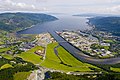
 View of the industrial area with the city in the background | |
 Orkanger Location of the town | |
| Coordinates: 63°18′24″N 9°51′01″E / 63.3067°N 09.8502°ECoordinates: 63°18′24″N 9°51′01″E / 63.3067°N 09.8502°E | |
| Country | Norway |
| Region | Central Norway |
| County | Trøndelag |
| District | Orkdalen |
| Municipality | Orkland |
| Established | 2014 (as a town) |
| Area | |
| • Total | 6.26 km2 (2.42 sq mi) |
| Elevation | 11 m (36 ft) |
| Population (2018)[1] | |
| • Total | 8,204 |
| • Density | 1,311/km2 (3,400/sq mi) |
| Demonym(s) | Ørbygg |
| Time zone | UTC+01:00 (CET) |
| • Summer (DST) | UTC+02:00 (CEST) |
| Post Code | 7300 Orkanger |
 Sør-Trøndelag within Norway | |
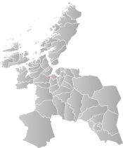 Orkanger within Sør-Trøndelag | |
| Country | Norway |
| County | Sør-Trøndelag |
| District | Orkdalen |
| Established | 1 July 1920 |
| Disestablished | 1 Jan 1963 |
| Administrative centre | Orkanger |
| Area | |
| • Total | 7 km2 (3 sq mi) |
| *Area at municipal dissolution. | |
| Population (1962) | |
| • Total | 2,874 |
| • Density | 410/km2 (1,100/sq mi) |
| Demonym(s) | Ørbygg[3] |
| ISO 3166 code | NO-1639 |
| Preceded by | Orkdal in 1920 |
| Succeeded by | Orkdal in 1963 |


Orkanger is a town and the administrative centre of Orkland municipality in Trøndelag county, Norway. The town is also a former municipality which existed from 1920 until 1963. The town sits at the end of the Orkdal Fjord, an arm of the Trondheimsfjord. Orkanger is the commercial centre of the municipality of Orkland and it is the site of the Orkanger Church. It was established as a "town" in 2014.[4]
Combined with the neighbouring suburban village of Fannrem, the conurbation constitutes one of the largest urban areas in Trøndelag county. The 6.26-square-kilometre (1,550-acre) town has a population (2018) of 8,204 and a population density of 1,311 inhabitants per square kilometre (3,400/sq mi).[1]
Just north of Orkanger lies the port of Thamshavn. Until 1974, Orkanger had a station on the Thamshavn Line railway with the Thamshavn Station just north of the town. The railway line closed for passenger traffic in 1963 but continued to transport ore from Løkken Verk to the Thamshavn port until 1974 when the line was closed to all traffic. The line through most of Orkanger was dismantled following the closure, but about 22 kilometres (14 mi) of the original line from Bårdshaug to Løkken Verk has been re-opened as a heritage railway.
Between 1908 and 1949 there was a steam ship service to Trondheim on the SS Orkla. The European route E39 highway runs through the town, connecting it to the major city of Trondheim, about 42 kilometres (26 mi) to the northeast.
Industry[]
Orkanger is one of the most important industrial centres in Trøndelag. The industrial sites are mainly located in the area, just west of the mouth of the Orkla river. Technip Offshore Norge AS, Reinertsen, and the foundry are the main operators in the area.
A chipboard factory operated in Orkanger from 1959 until 1976.
History[]
The urban area of Orkanger was established as a municipality on 1 July 1920 when it was separated from Orkdal municipality. Initially, it had a population of 1,715. The municipality encompassed the 7-square-kilometre (2.7 sq mi) urban area and some of the surrounding countryside. It was an important port, but it did not have the designation of a town at that time.
During the 1960s, there were many municipal mergers across Norway due to the work of the Schei Committee. On 1 January 1963, the municipality of Orkanger ceased to exist and it was merged into the larger municipality of Orkdal. Prior to the merger, Orkanger had 2,874 residents.[5] In 2014, the municipality of Orkdal declared Orkanger to be a "town".
Municipal council[]
During its time as an independent municipality, the municipal council (Herredsstyre) of Orkanger was made up of representatives that were elected to four year terms. The party breakdown of the final municipal council was as follows:
| Party Name (in Norwegian) | Number of representatives | |
|---|---|---|
| Labour Party (Arbeiderpartiet) | 12 | |
| Conservative Party (Høyre) | 2 | |
| Communist Party (Kommunistiske Parti) | 5 | |
| Liberal Party (Venstre) | 2 | |
| Total number of members: | 21 | |
Name[]
The name "Orkanger" is composed of the name "Ork", which stems from the lake from which the river Orkla runs. The second element of the name (Old Norse: angr) means "narrow fjord".[4]
Gallery[]

Orkanger seen towards northwest. By Åge Hojem, Trondheim havn.
Orkanger seen towards north, with Orkdal Fjord in the background. By Åge Hojem, Trondheim havn.

Orkanger seen towards southwest. By Åge Hojem, Trondheim havn.
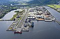
Orkanger harbour and industrial area. By Åge Hojem, Trondheim havn.


See also[]
References[]
- ^ Jump up to: a b c Statistisk sentralbyrå (1 January 2018). "Urban settlements. Population and area, by municipality".
- ^ "Orkanger, Orkdal (Trøndelag)". yr.no. Retrieved 2018-02-03.
- ^ "Navn på steder og personer: Innbyggjarnamn" (in Norwegian). Språkrådet.
- ^ Jump up to: a b Store norske leksikon. "Orkanger. – kommune" (in Norwegian). Retrieved 2011-01-28.
- ^ Jukvam, Dag (1999). "Historisk oversikt over endringer i kommune- og fylkesinndelingen" (PDF) (in Norwegian). Statistisk sentralbyrå.
- ^ "Kommunevalgene og Ordførervalgene 1959" (PDF) (in Norwegian). Oslo: Statistisk sentralbyrå. 1960. Retrieved 2020-04-20.
- ^ "Kommunevalgene og Ordførervalgene 1955" (PDF) (in Norwegian). Oslo: Statistisk sentralbyrå. 1957. Retrieved 2020-04-20.
- ^ "Kommunevalgene og Ordførervalgene 1951" (PDF) (in Norwegian). Oslo: Statistisk sentralbyrå. 1952. Retrieved 2020-04-20.
- ^ "Kommunevalgene og Ordførervalgene 1947" (PDF) (in Norwegian). Oslo: Statistisk sentralbyrå. 1948. Retrieved 2020-04-20.
- ^ "Kommunevalgene og Ordførervalgene 1945" (PDF) (in Norwegian). Oslo: Statistisk sentralbyrå. 1947. Retrieved 2020-04-20.
- ^ "Kommunevalgene og Ordførervalgene 1937" (PDF) (in Norwegian). Oslo: Statistisk sentralbyrå. 1938. Retrieved 2020-04-20.
| hide | |||
|---|---|---|---|
| |||
 | Towns and cities |  | |
| Municipalities | |||
- Cities and towns in Norway
- Former municipalities of Norway
- Orkland
- Populated places in Trøndelag
- 1920 establishments in Norway
- 1963 disestablishments in Norway
- 2014 establishments in Norway