Stadsbygd (municipality)
Stadsbygd herred | |
|---|---|
 | |
 Sør-Trøndelag within Norway | |
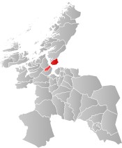 Stadsbygd within Sør-Trøndelag | |
| Coordinates: 63°30′34″N 10°01′09″E / 63.50944°N 10.01917°ECoordinates: 63°30′34″N 10°01′09″E / 63.50944°N 10.01917°E | |
| Country | Norway |
| County | Sør-Trøndelag |
| District | Fosen |
| Established | 1 Jan 1838 |
| Disestablished | 1 Jan 1964 |
| Administrative centre | Stadsbygd |
| Area | |
| • Total | 137 km2 (53 sq mi) |
| *Area at municipal dissolution. | |
| Population (1964) | |
| • Total | 1,787 |
| • Density | 13/km2 (34/sq mi) |
| Demonym(s) | stadværing[1] |
| Time zone | UTC+01:00 (CET) |
| • Summer (DST) | UTC+02:00 (CEST) |
| ISO 3166 code | NO-1625 |
| Created as | Formannskapsdistrikt in 1838 |
| Succeeded by | Rissa and Agdenes in 1964 |

Stadsbygd is a former municipality in the old Sør-Trøndelag county, Norway. The municipality existed from 1838 until its dissolution in 1964. The 137-square-kilometre (53 sq mi) municipality existed on the southern part of the Fosen peninsula, along the Trondheimsfjorden in what is now the municipality of Indre Fosen in Trøndelag county. The administrative centre was the village of Stadsbygd, just north of the Stadsbygd Church.[2]
History[]
The municipality of Stadsbygd was established on 1 January 1838 (see formannskapsdistrikt). In 1860, the northwestern district of Stadsbygd (population: 3,733) was separated to form a municipality the new municipality of Rissa. The split left Stadsbygd with a population of 1,828. During the 1960s, there were many municipal mergers across Norway due to the work of the Schei Committee. On 1 January 1964, the Ingdalen district south of the Trondheimsfjord (population: 171) was merged into the municipality of Agdenes. The rest of Stadsbygd, north of the Trondheimsfjord, (population: 1,616) was merged with the neighboring municipalities of Rissa (population: 3,264) and the southern part of the municipality of Stjørna (population: 1,868).[3]
Government[]
All municipalities in Norway, including Stadsbygd, are responsible for primary education (through 10th grade), outpatient health services, senior citizen services, unemployment and other social services, zoning, economic development, and municipal roads. The municipality is governed by a municipal council of elected representatives, which in turn elects a mayor.[4]
Municipal council[]
The municipal council (Herredsstyre) of Stadsbygd was made up of representatives that were elected to four year terms. The party breakdown of the final municipal council was as follows:
| Party Name (in Norwegian) | Number of representatives | |
|---|---|---|
| Labour Party (Arbeiderpartiet) | 6 | |
| Conservative Party (Høyre) | 2 | |
| Christian Democratic Party (Kristelig Folkeparti) | 3 | |
| Centre Party (Senterpartiet) | 5 | |
| Liberal Party (Venstre) | 2 | |
| Local List(s) (Lokale lister) | 3 | |
| Total number of members: | 21 | |
| Party Name (in Norwegian) | Number of representatives | |
|---|---|---|
| Labour Party (Arbeiderpartiet) | 5 | |
| Conservative Party (Høyre) | 2 | |
| Christian Democratic Party (Kristelig Folkeparti) | 3 | |
| Farmers' Party (Bondepartiet) | 4 | |
| Liberal Party (Venstre) | 2 | |
| Local List(s) (Lokale lister) | 5 | |
| Total number of members: | 21 | |
| Party Name (in Norwegian) | Number of representatives | |
|---|---|---|
| Labour Party (Arbeiderpartiet) | 4 | |
| Conservative Party (Høyre) | 2 | |
| Christian Democratic Party (Kristelig Folkeparti) | 2 | |
| Farmers' Party (Bondepartiet) | 4 | |
| Liberal Party (Venstre) | 3 | |
| Local List(s) (Lokale lister) | 5 | |
| Total number of members: | 20 | |
| Party Name (in Norwegian) | Number of representatives | |
|---|---|---|
| Labour Party (Arbeiderpartiet) | 4 | |
| Conservative Party (Høyre) | 1 | |
| Christian Democratic Party (Kristelig Folkeparti) | 3 | |
| Farmers' Party (Bondepartiet) | 4 | |
| Liberal Party (Venstre) | 3 | |
| Local List(s) (Lokale lister) | 5 | |
| Total number of members: | 20 | |
| Party Name (in Norwegian) | Number of representatives | |
|---|---|---|
| Labour Party (Arbeiderpartiet) | 4 | |
| Conservative Party (Høyre) | 1 | |
| Christian Democratic Party (Kristelig Folkeparti) | 2 | |
| Farmers' Party (Bondepartiet) | 4 | |
| Liberal Party (Venstre) | 3 | |
| Local List(s) (Lokale lister) | 6 | |
| Total number of members: | 20 | |
| Party Name (in Norwegian) | Number of representatives | |
|---|---|---|
| Labour Party (Arbeiderpartiet) | 3 | |
| Conservative Party (Høyre) | 1 | |
| Farmers' Party (Bondepartiet) | 6 | |
| Liberal Party (Venstre) | 5 | |
| Local List(s) (Lokale lister) | 5 | |
| Total number of members: | 20 | |
See also[]
References[]
- ^ "Navn på steder og personer: Innbyggjarnamn" (in Norwegian). Språkrådet.
- ^ Rosvold, Knut A., ed. (2018-01-04). "Stadsbygd". Store norske leksikon (in Norwegian). Kunnskapsforlaget. Retrieved 2018-03-04.
- ^ Jukvam, Dag (1999). "Historisk oversikt over endringer i kommune- og fylkesinndelingen" (PDF) (in Norwegian). Statistisk sentralbyrå.
- ^ Hansen, Tore, ed. (2016-05-12). "kommunestyre". Store norske leksikon (in Norwegian). Kunnskapsforlaget. Retrieved 2020-02-02.
- ^ "Kommunevalgene og Ordførervalgene 1959" (PDF) (in Norwegian). Oslo: Statistisk sentralbyrå. 1960. Retrieved 2020-04-14.
- ^ "Kommunevalgene og Ordførervalgene 1955" (PDF) (in Norwegian). Oslo: Statistisk sentralbyrå. 1957. Retrieved 2020-04-14.
- ^ "Kommunevalgene og Ordførervalgene 1951" (PDF) (in Norwegian). Oslo: Statistisk sentralbyrå. 1952. Retrieved 2020-04-14.
- ^ "Kommunevalgene og Ordførervalgene 1947" (PDF) (in Norwegian). Oslo: Statistisk sentralbyrå. 1948. Retrieved 2020-04-14.
- ^ "Kommunevalgene og Ordførervalgene 1945" (PDF) (in Norwegian). Oslo: Statistisk sentralbyrå. 1947. Retrieved 2020-04-14.
- ^ "Kommunevalgene og Ordførervalgene 1937" (PDF) (in Norwegian). Oslo: Statistisk sentralbyrå. 1938. Retrieved 2020-04-14.
| |||
 | Towns and cities |  | |
| Municipalities | |||
- Indre Fosen
- Former municipalities of Norway
- 1838 establishments in Norway
- 1964 disestablishments in Norway