Nantouillet
This article relies largely or entirely on a single source. (June 2020) |
Nantouillet | |
|---|---|
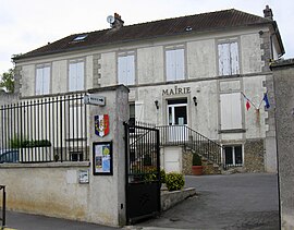 The town hall of Nantouillet | |
 Coat of arms | |
 | |
show Location of Nantouillet | |
 Nantouillet | |
| Coordinates: 49°00′08″N 2°42′13″E / 49.0022°N 2.7035°ECoordinates: 49°00′08″N 2°42′13″E / 49.0022°N 2.7035°E | |
| Country | France |
| Region | Île-de-France |
| Department | Seine-et-Marne |
| Arrondissement | Meaux |
| Canton | Mitry-Mory |
| Intercommunality | CC Plaines et Monts de France |
| Government | |
| • Mayor (2020–2026) | Yannick Urbaniak |
| Area 1 | 5.15 km2 (1.99 sq mi) |
| Population (Jan. 2018)[1] | 279 |
| • Density | 54/km2 (140/sq mi) |
| Time zone | UTC+01:00 (CET) |
| • Summer (DST) | UTC+02:00 (CEST) |
| INSEE/Postal code | 77332 /77230 |
| Elevation | 63–118 m (207–387 ft) |
| 1 French Land Register data, which excludes lakes, ponds, glaciers > 1 km2 (0.386 sq mi or 247 acres) and river estuaries. | |


Nantouillet (French pronunciation: [nɑ̃tujɛ] (![]() listen)) is a commune in the Seine-et-Marne department in the Île-de-France region in north-central France.
listen)) is a commune in the Seine-et-Marne department in the Île-de-France region in north-central France.
Demographics[]
The inhabitants are called the Nantolétains.
See also[]
- Communes of the Seine-et-Marne department
References[]
- ^ "Populations légales 2018". INSEE. 28 December 2020.
External links[]
| Wikimedia Commons has media related to Nantouillet. |
- 1999 Land Use, from IAURIF (Institute for Urban Planning and Development of the Paris-Île-de-France région) (in English)
- Base Mérimée: Search for heritage in the commune, Ministère français de la Culture. (in French)
| show Communes of the Seine-et-Marne department |
|---|
This article related to a Seine-et-Marne location is a stub. You can help Wikipedia by . |
Categories:
- Communes of Seine-et-Marne
- Seine-et-Marne geography stubs