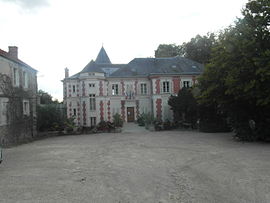
Pringy, Seine-et-Marne
Pringy | |
|---|---|
 The town hall in Pringy | |
 Coat of arms | |
show Location of Pringy | |
 Pringy | |
| Coordinates: 48°31′19″N 2°33′35″E / 48.5219°N 2.5597°ECoordinates: 48°31′19″N 2°33′35″E / 48.5219°N 2.5597°E | |
| Country | France |
| Region | Île-de-France |
| Department | Seine-et-Marne |
| Arrondissement | Melun |
| Canton | Saint-Fargeau-Ponthierry |
| Intercommunality | CA Melun Val de Seine |
| Government | |
| • Mayor (2020–2026) | Éric Chomaudon |
| Area 1 | 4.10 km2 (1.58 sq mi) |
| Population (Jan. 2018)[1] | 2,894 |
| • Density | 710/km2 (1,800/sq mi) |
| Time zone | UTC+01:00 (CET) |
| • Summer (DST) | UTC+02:00 (CEST) |
| INSEE/Postal code | 77378 /77310 |
| Elevation | 40–79 m (131–259 ft) |
| 1 French Land Register data, which excludes lakes, ponds, glaciers > 1 km2 (0.386 sq mi or 247 acres) and river estuaries. | |
Pringy (French pronunciation: [pʁɛ̃ʒi] (![]() listen)) is a commune in the Seine-et-Marne department in the Île-de-France region in north-central France. As of 2018, the population was reported as 2,894. [2]
listen)) is a commune in the Seine-et-Marne department in the Île-de-France region in north-central France. As of 2018, the population was reported as 2,894. [2]
Demographics[]
The inhabitants are called Pringyaciens.
Pringy is twinned with the English town of Pucklechurch, near Bristol.
See also[]
- Communes of the Seine-et-Marne department
References[]
- ^ "Populations légales 2018". INSEE. 28 December 2020.
- ^ "Pringy". www.wikidata.org. Retrieved 2021-04-07.
External links[]
| Wikimedia Commons has media related to Pringy (Seine-et-Marne). |
- 1999 Land Use, from IAURIF (Institute for Urban Planning and Development of the Paris-Île-de-France région) (in English)
- Base Mérimée: Search for heritage in the commune, Ministère français de la Culture. (in French)
Categories:
- Communes of Seine-et-Marne
- Seine-et-Marne geography stubs


