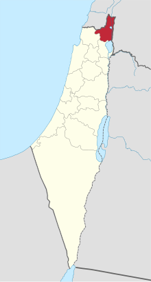
Safad Subdistrict, Mandatory Palestine
| Safad Subdistrict قضاء صفد נפת צפת | |||||||||
|---|---|---|---|---|---|---|---|---|---|
| Subdistrict of Mandatory Palestine | |||||||||
| 1920–1948 | |||||||||
 | |||||||||
| Capital | Safad | ||||||||
| Area | |||||||||
• 1945 | 696 km2 (269 sq mi) | ||||||||
| Population | |||||||||
• 1931 | 39,713 | ||||||||
• 1945 | 53,620 | ||||||||
| History | |||||||||
| History | |||||||||
• Established | 1920 | ||||||||
• Disestablished | 1948 | ||||||||
| |||||||||
| Today part of | Israel | ||||||||
The Safad Subdistrict (Arabic: قضاء صفد, Hebrew: נפת צפת) was one of the subdistricts of Mandatory Palestine before it became occupied by Israel in 1948. It was located around the city of Safad. After the 1948 Arab-Israeli War, the subdistrict, which fell entirely within modern-day Israel, became the modern-day Safed Subdistrict in the Northern District (Israel).
Borders[]
- Acre Subdistrict (South West)
- Tiberias Subdistrict (South)
- Lebanon (North)
- Syria (East)
Depopulated towns and villages[]

Official population statistics for the sub-district, from Village Statistics, 1945.
(current localities in parentheses)
|
|
|
| Acre Subdistrict |
| |
|---|---|---|
| Beisan Subdistrict |
| |
| Beersheba Subdistrict |
| |
| Gaza Subdistrict |
| |
| Haifa Subdistrict |
| |
| Hebron Subdistrict | ||
| Jaffa Subdistrict |
| |
| Jenin Subdistrict | ||
| Jerusalem Subdistrict |
| |
| Nazareth Subdistrict |
| |
| Ramle Subdistrict |
| |
| Safad Subdistrict |
| |
| Tiberias Subdistrict |
| |
| Tulkarm Subdistrict |
| |

This article relating to the British Mandate for Palestine is a stub. You can help Wikipedia by . |
Categories:
- States and territories established in 1920
- States and territories disestablished in 1948
- Subdistricts of Mandatory Palestine
- District of Safad
- Mandatory Palestine stubs