Wadi Qabbani
Wadi Qabbani
وادي قباني | |
|---|---|
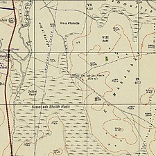
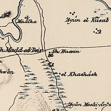
 A series of historical maps of the area around Wadi Qabbani (click the buttons) | |
 Wadi Qabbani Location within Mandatory Palestine | |
| Coordinates: 32°21′44″N 34°55′18″E / 32.36222°N 34.92167°ECoordinates: 32°21′44″N 34°55′18″E / 32.36222°N 34.92167°E | |
| Palestine grid | 142/196 |
| Geopolitical entity | Mandatory Palestine |
| Subdistrict | Tulkarm |
| Date of depopulation | Not known[3] |
| Area | |
| • Total | 9,812 dunams (9.812 km2 or 3.788 sq mi) |
| Population (1945) | |
| • Total | 320[1][2] |
| Current Localities | HaOgen[4] |
Wadi Qabbani (Arabic: وادي قباني), also known as Khirbat ash Sheik Husein (Arabic: خربة الشيخ حسين) was a Palestinian Arab village in the Tulkarm Subdistrict. It was probably depopulated during the 1947–48 Civil War in Mandatory Palestine on March 1, 1948 as part of . It was located 12 km northwest of Tulkarm. The name, Qabbani came from the Lebanese family who owned most of the land.
History[]
British Mandate era[]
In the 1945 statistics the village had a total population of 210 Muslims[1] with a total of 9,812 dunams of land.[2]
The land ownership of the village before occupation in dunams:[1][2]
| Owner | Dunams |
|---|---|
| Arab | 427 |
| Jewish | 9,276 |
| Public | 109 |
| Total | 9,812 |
Of this, Arabs used 408 dunums for cereals,[5] while a total of 1,301 dunams were classified as non-cultivable land.[6]
Types of land use in dunams in the village in 1945:[5][6]
| Land Usage | Arab | Jewish | Public |
|---|---|---|---|
| Citrus and bananas | - | 46 | - |
| Irrigated and plantation | - | - | - |
| Cereal | 408 | 8,057 | - |
| Urban | - | - | - |
| Cultivable | 408 | 8,103 | - |
| Non-cultivable | 19 | 1,173 | 109 |
References[]
- ^ a b c Department of Statistics, 1945, p. 22
- ^ a b c d Government of Palestine, Department of Statistics. Village Statistics, April, 1945. Quoted in Hadawi, 1970, p. 77
- ^ Morris, 2004, p. xviii, village #186. Gives both date and cause of depopulation as "Not known"
- ^ Khalidi, 1992, p. 566
- ^ a b Government of Palestine, Department of Statistics. Village Statistics, April, 1945. Quoted in Hadawi, 1970, p. 128
- ^ a b Government of Palestine, Department of Statistics. Village Statistics, April, 1945. Quoted in Hadawi, 1970, p. 178
Bibliography[]
- Department of Statistics (1945). Village Statistics, April, 1945. Government of Palestine.
- Hadawi, S. (1970). Village Statistics of 1945: A Classification of Land and Area ownership in Palestine. Palestine Liberation Organization Research Center.
- Khalidi, W. (1992). All That Remains: The Palestinian Villages Occupied and Depopulated by Israel in 1948. Washington D.C.: Institute for Palestine Studies. ISBN 0-88728-224-5.
- Morris, B. (2004). The Birth of the Palestinian Refugee Problem Revisited. Cambridge University Press. ISBN 978-0-521-00967-6.
External links[]
- Welcome To Wadi Qabbani
- Wadi Qabbani, Zochrot
- Survey of Western Palestine, Map 10: IAA, Wikimedia commons
- Arab villages depopulated during the 1948 Arab–Israeli War
- District of Tulkarm


