Khirbat Bayt Lid
Khirbat Bayt Lid
خربة بيت لد Khirbet Beit Lid[1] | |
|---|---|
Village | |
| Etymology: El Mughair=the caves[2] | |
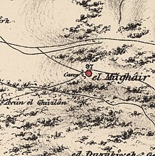
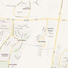
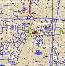
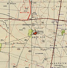 A series of historical maps of the area around Khirbat Bayt Lid (click the buttons) | |
 Khirbat Bayt Lid Location within Mandatory Palestine | |
| Coordinates: 32°19′04″N 34°53′33″E / 32.31778°N 34.89250°ECoordinates: 32°19′04″N 34°53′33″E / 32.31778°N 34.89250°E | |
| Palestine grid | 140/191 |
| Geopolitical entity | Mandatory Palestine |
| Subdistrict | Tulkarm |
| Date of depopulation | 5 April 1948[1] |
| Area (2,969 Arab, 2,220 Jewish)[3] | |
| • Total | 5,336 dunams (5.336 km2 or 2.060 sq mi) |
| Population | |
| • Total | 460 |
| Cause(s) of depopulation | Fear of being caught up in the fighting |
| Current Localities | Nordia[5][6] |

Khirbat Bayt Lid (Arabic: خربة بيت لد) was a Palestinian Arab village in the Tulkarm Subdistrict. It was depopulated by its Arab inhabitants during the 1948 Arab–Israeli War.
History[]
500 meters north of Khirbat Bayt Lid was El Mughair, which was described in 1882 by PEF's Survey of Western Palestine as "a small mud hamlet, with caves. The water supply is from springs a mile to the west."[7]
Originally, the people of Khirbat Beit Lid came from Beit Lid to farm the lower plain village land. Gradually they settled in the village so they could be closer to their land.[6]
British Mandate era[]
In the 1922 census of Palestine conducted by the British Mandate authorities, Kherbet Bait Lid had a population of 206 Muslims,[8] increasing in the 1931 census to 298 Muslim, in a total of 75 houses.[9]
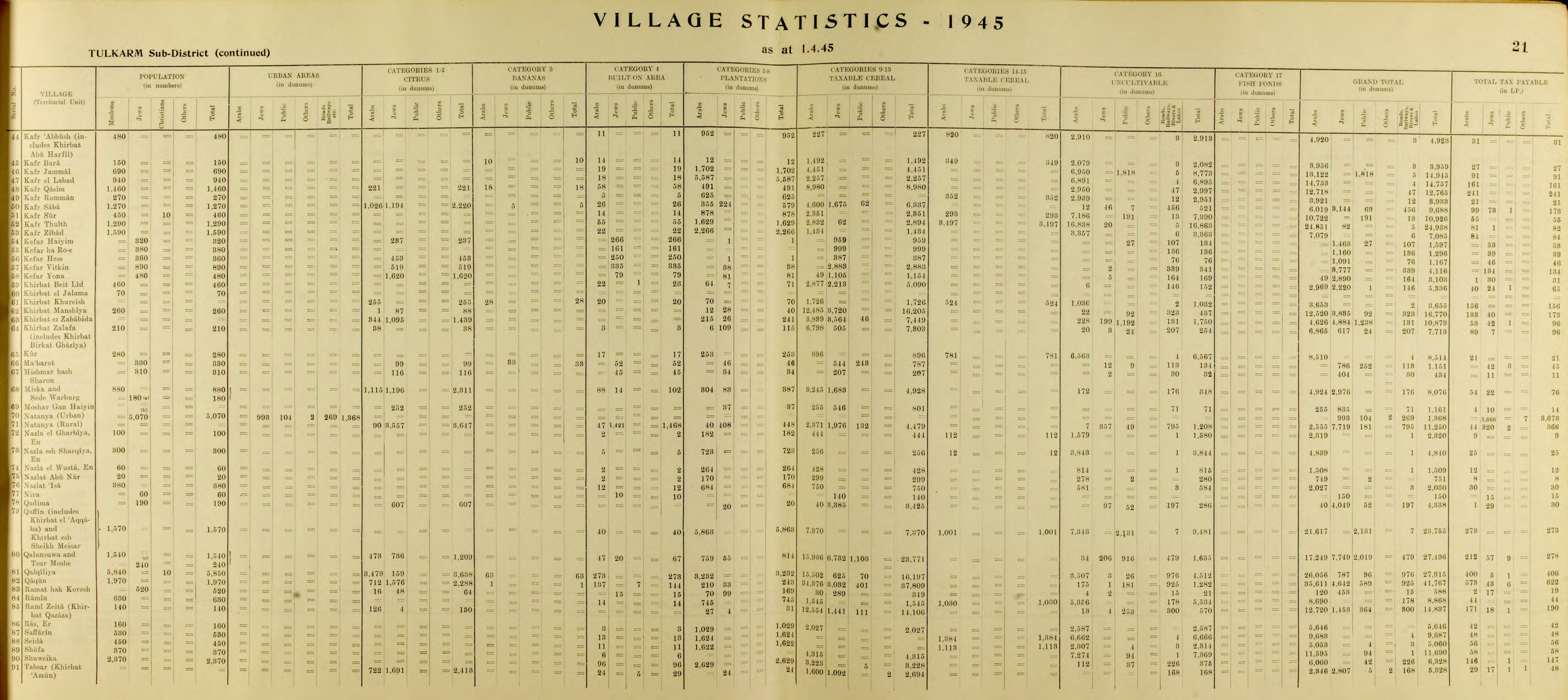
In the 1945 statistics the population of Khirbat Bayt Lid was 460 Muslims[4] with a total of 5,336 dunams of land, of which 2,969 were owned by Arabs, 2,220 by Jews and 147 was public lands.[3]
Of this, Arabs used 64 dunams for irrigated and plantation land, 2,877 for cereals,[10] while 22 dunams were classified as built-up areas.[11]
| Land Usage | Arab | Jewish | Public |
|---|---|---|---|
| Citrus and bananas | - | - | - |
| Irrigated and plantation | 64 | 7 | |
| Cereal | 2,877 | 2,213 | - |
| Urban | 22 | - | 1 |
| Cultivable | 2,941 | 2,220 | - |
| Non-cultivable | 6 | - | 146 |


1948, aftermath[]
In early 1948 the villagers grew fearful over news about fighting, and left for Beit Lid, where they had relatives, believing that they would return in some weeks. According to one villager, Husni 'Abd al-Latif 'Atawat; "They left all their belongings in Khirbat Bayt Lid. The Jews occupied it, and they could not return."[12]
The Moshav Nordia was established on village land in August 1948,[5][6] while Ganot Hadar is situated 500 meter northeast of the village site, but not on village land.[6] Benny Morris writes that HaYogev is close to the Khirbat Bayt Lid site.[13]
References[]
- ^ a b Morris, 2004, p. xviii, village #189. Also gives cause of depopulation
- ^ Palmer, 1881, p. 175
- ^ a b c Government of Palestine, Department of Statistics. Village Statistics, April, 1945. Quoted in Hadawi, 1970, p. 75
- ^ a b Department of Statistics, 1945, p. 21
- ^ a b Morris, 2004, p. xxi, settlement #23.
- ^ a b c d Khalidi, 1992, p. 550.
- ^ Conder and Kitchener, 1882, p. 135
- ^ Barron, 1923, Table IX, Sub-district of Tulkarem, p. 28
- ^ Mills, 1932, p. 53
- ^ Government of Palestine, Department of Statistics. Village Statistics, April, 1945. Quoted in Hadawi, 1970, p. 126
- ^ Government of Palestine, Department of Statistics. Village Statistics, April, 1945. Quoted in Hadawi, 1970, p. 176
- ^ Esber, 2008, pp. 296, 321. Interviewed by the author in Zarqa, Jordan, in 2001
- ^ Morris, 2004, p. xxii, settlement #148
Bibliography[]
- Barron, J. B., ed. (1923). Palestine: Report and General Abstracts of the Census of 1922. Government of Palestine.
- Conder, C.R.; Kitchener, H.H. (1882). The Survey of Western Palestine: Memoirs of the Topography, Orography, Hydrography, and Archaeology. 2. London: Committee of the Palestine Exploration Fund.
- Department of Statistics (1945). Village Statistics, April, 1945. Government of Palestine.
- Esber, R.M. (2008). Under the Cover of War, The Zionist Expulsions of the Palestinians. Arabicus Books & Media. ISBN 978-0981513171.
- Hadawi, S. (1970). Village Statistics of 1945: A Classification of Land and Area ownership in Palestine. Palestine Liberation Organization Research Center.
- Khalidi, W. (1992). All That Remains: The Palestinian Villages Occupied and Depopulated by Israel in 1948. Washington D.C.: Institute for Palestine Studies. ISBN 0-88728-224-5.
- Mills, E., ed. (1932). Census of Palestine 1931. Population of Villages, Towns and Administrative Areas. Jerusalem: Government of Palestine.
- Morris, B. (2004). The Birth of the Palestinian Refugee Problem Revisited. Cambridge University Press. ISBN 978-0-521-00967-6.
- Palmer, E.H. (1881). The Survey of Western Palestine: Arabic and English Name Lists Collected During the Survey by Lieutenants Conder and Kitchener, R. E. Transliterated and Explained by E.H. Palmer. Committee of the Palestine Exploration Fund.
External links[]
- Welcome To Bayt Lid, Khirbat
- Khirbat Bayt Lid, Zochrot
- Survey of Western Palestine, Map 10: IAA, Wikimedia commons
- Bayt Lid, Khirbat, from Khalil Sakakini Cultural Center

- Arab villages depopulated during the 1948 Arab–Israeli War
- District of Tulkarm