Kafr 'Ana
Kafr 'Ana
كفرعانا Kafar Ana | |
|---|---|
 Kafr 'Ana mosque | |
| Etymology: The village of Ana[1] | |
 A series of historical maps of the area around Kafr 'Ana (click the buttons) | |
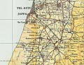
 Kafr 'Ana Location within Mandatory Palestine | |
| Coordinates: 32°1′28″N 34°52′7″E / 32.02444°N 34.86861°ECoordinates: 32°1′28″N 34°52′7″E / 32.02444°N 34.86861°E | |
| Palestine grid | 137/159 |
| Geopolitical entity | Mandatory Palestine |
| Subdistrict | Jaffa |
| Date of depopulation | April 25, 1948[4] |
| Area | |
| • Total | 17,553 dunams (17.553 km2 or 6.777 sq mi) |
| Population (1945) | |
| • Total | 3,020[2][3] |
| Cause(s) of depopulation | Military assault by Yishuv forces |
| Current Localities | Neve Monosson[5] Yagel[5] Or Yehuda[6] |


Kafr 'Ana' (Arabic: كفرئنا, also: Kafr Ana) was a Palestinian town located 11 kilometers (6.8 mi) east of Jaffa, built on the ancient site of Ono. In 1945, the town had an estimated population of 2,800 Arabs and 220 Jews. Captured by the pre-state Jewish forces of the Alexandroni Brigade prior to the outbreak of the 1948 Arab–Israeli War, it was depopulated. Today, the old village site lies within the confines of the modern Israeli city of Or Yehuda.
History[]
Remains from the Chalcolithic Period and forward have been found here.[6] The Canaanites and Israelites referred to the town as Ono (1 Chronicles 8:12), which name continued all throughout the First and Second Temple periods.[7]
Byzantine period[]
Jewish classical writings mention the city as being formerly enclosed by a wall.[8][9] Kafr 'Ana was known as Onous in the Byzantine era,[10] and ceramics from that era have been found here.[11] Kafr 'Ana actually represents a Byzantine-period expansion of a nearby and much older site –– Kafr Juna, believed to be the ancient Ono.[12]
Ottoman period[]
During early Ottoman rule in Palestine, the revenues of the village of Kafr 'Ana were in 1557 designated for the new waqf of Hasseki Sultan Imaret in Jerusalem, established by Hasseki Hurrem Sultan (Roxelana), the wife of Suleiman the Magnificent.[13] In 1596, Kafr 'Ana appeared in the census located in the Nahiya of Ramla, part of Gaza Sanjak. The population was 11 households, all Muslim. They paid a fixed tax-rate of 25% on agricultural products, including wheat, barley, summer crops, vineyards, fruit trees, sesame, goats and beehives; in addition to occasional revenues, a total of 26,800 akçe. All of the revenue went to a waqf.[14]
In 1838, Kefr Ana was noted as a Muslim village in the Lydda District.[15]
French explorer Victor Guérin visited the village in 1863 and found it to have 500 inhabitants.[16] He further noted that "near the village are two shallow basins hollowed in rock, not built up, which receive the winter rains. Several wells are here as well, which permit the gardens to be irrigated. By the side of one of these wells I observed trunks of columns which seemed ancient."[17]
An Ottoman village list of about 1870 counted 156 houses and a population of 499, though the population count included men, only.[18][19]
In 1882, the PEF's Survey of Western Palestine described Kafr 'Ana as a village built of adobe bricks and surrounded by palm trees.[20]
British Mandate period[]
In the 1922 census of Palestine conducted by the British Mandate authorities, Kufr 'Ana had a population of 1,374 inhabitants, all Muslims.[21] increasing the 1931 census to 1,824, still all Muslims, in a total of 449 houses.[22]
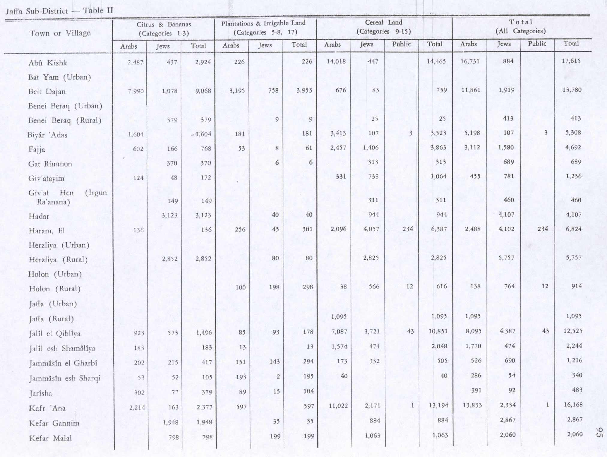
The villagers grew crops and raised poultry and bees. In the 1944/45 statistics a total 2,214 dunums were used for growing citrus and bananas, while 11,022 dunums of village land was used for cereals. 597 dunums were irrigated or used for orchards,[10][23] while 90 dunams were classified as built-up areas.[24]

Kafr ‘Ana 1947 from Palmach archive
Kafr 'Ana 1945 1:250,000


State of Israel[]

The village of Kafr 'Ana was depopulated in the weeks leading up to the 1948 Arab–Israeli War, during the Haganah's offensive Mivtza Hametz (Operation Hametz) 28–30 April 1948. This operation was held against a group of villages east of Jaffa, including Kafr 'Ana. According to the preparatory orders, the objective was for "opening the way [for Jewish forces] to Lydda". Though there was no explicit mention of the prospective treatment of the villagers, the order spoke of "cleansing the area" [tihur hashetah].[25] The final operational order stated: "Civilian inhabitants of places conquered would be permitted to leave after they are searched for weapons."[26]
On 23 September 1948 General Avner named Kafr 'Ana as a suitable village for resettlement for new Jewish immigrants ("olim") to Israel.[27] Today, the modern Israeli city, Or Yehuda, is built upon the lands formerly belonging to Kafr 'Ana and Saqiya village and Kheiriya village.[28] Or Yehuda was founded in 1950, on village land, south of the village site.[5]
In 1992 the village site was described: "Part of the site is a vacant lot. On other parts, olive trees grow, along with cypress and eucalyptus trees that have been planted by the residents of the Israeli settlements. No traces of the old houses can be discerned. Apartment buildings and a small park have been built on the surrounding land."[5]
Culture[]
A woman's thob (loose fitting robe with sleeves), from Kafr Ana, from the 1930s, is in the Museum of International Folk Art (MOIFA) collection at Santa Fe, United States. The dress is of white commercial cotton and the embroidery is multicolored cotton, mainly in red and blue. The qabbeh (the square chest panel) is not a separate panel, but instead executed directly on the dress. The embroidery on the skirt and sleeves is also done directly on the dress. There is some machine embroidery, but most is by hand. The dress has an uncommon round neckline, which was an innovation and was only used here and in the village of Salama, near Jaffa.[29]
See also[]
- Depopulated Palestinian locations in Israel
- Palestinian costumes
References[]
- ^ Palmer, 1881, p. 215
- ^ Government of Palestine, Department of Statistics, 1945, p. 27
- ^ Jump up to: a b Government of Palestine, Department of Statistics. Village Statistics, April, 1945. Quoted in Hadawi, 1970, p. 52
- ^ Morris, 2004, p. xviii, village #218. Also gives cause of depopulation.
- ^ Jump up to: a b c d Khalidi, 1882, p. 248
- ^ Jump up to: a b Volynsky and Arbel, 2015, Or Yehuda
- ^ Christie, W.M. (1925). "The Jamnia Period in Jewish History". The Journal of Theological Studies. 26 (104): 348. JSTOR 23950037.;Maisler (Mazar), Benjamin (1932). "The Method of Transcribing Geographical and Personal Names". Lĕšonénu: A Journal for the Study of the Hebrew Language and Cognate Subjects: 19. JSTOR 24384308.; Shmuel Klein, Eretz Yehudah (Heb. ארץ יהודה : מימי העליה מבבל עד חתימת התלמוד), Tel-Aviv 1939, s.v. אונו (Ono)
- ^ Mishnah (Arakhin 9:6).
- ^ Ishtori Haparchi, Kaphtor u'ferach (ed. Avraham Yosef Havatzelet), vol. II (third edition), chapter 11, s.v. מלוד לאונו, Jerusalem 2007, p. 75 (note 265), who cites Mishna Arakhin 9:6 as proof of antiquity (Hebrew).
- ^ Jump up to: a b Khalidi, 1992, p. 247
- ^ Dauphin, 1998, p. 824
- ^ See p. 175 in: Taxel, Itamar (May 2013). "Rural Settlement Processes in Central Palestine, ca. 640–800 c.e.: The Ramla-Yavneh Region as a Case Study". Bulletin of the American Schools of Oriental Research. 369 (369): 157–199. doi:10.5615/bullamerschoorie.369.0157. JSTOR 10.5615/bullamerschoorie.369.0157. S2CID 163507411.
- ^ Singer, 2002, p.52
- ^ Hütteroth and Abdulfattah, 1977, p. 156. Note that Khalidi, 1992, p. 247 here mixed this Kafr 'Ana up with a Kafr Ana in the Jerusalem district; Hütteroth and Abdulfattah, 1977, p. 119
- ^ Robinson and Smith, 1841, vol 3, Appendix 2, p. 121
- ^ Guérin, 1868, p. 319
- ^ Guérin, 1868, p. 320, as translated by Conder and Kitchener, 1882, SWP II, p. 265
- ^ Socin, 1879, p. 156 also noted it was located in the Lydda District
- ^ Hartmann, 1883, p. 138, noted 153 houses
- ^ Conder and Kitchener, 1882, SWP II, 251. Quoted in Khalidi, 1992, p. 247
- ^ Barron, 1923, Table VII, Sub-district of Jaffa, p. 20
- ^ Mills, 1932, p. 14.
- ^ Government of Palestine, Department of Statistics. Village Statistics, April, 1945. Quoted in Hadawi, 1970, p. 95
- ^ Government of Palestine, Department of Statistics. Village Statistics, April, 1945. Quoted in Hadawi, 1970, p. 145
- ^ HGS\Operations to Alexandroni, etc., "Orders for Operation "Hametz", 26 April 1948. IDFA 6647\49\\15. Cited in Morris, 2004, pp. 217, 286
- ^ Operation Hametz HQ to Givati, etc., 27 April 1948, 14:00 hours, IDFA 67\51\\677. See also Alexandroni to battalions, 27 April 1948, IDFA 922\75\\949. Cited in Morris, 2004, pp. 217, 286
- ^ Protocol of Meeting of Military Government Committee, 23 September 1948, ISA FM 2564\11. Cited in Morris, 2004, pp. 394, 413
- ^ Khalidi, 1992, pp. 247-248; Carta's Official Guide to Israel, Jerusalem 1983, p. 358.
- ^ Stillman, 1979, p.70
Bibliography[]
- Barron, J.B., ed. (1923). Palestine: Report and General Abstracts of the Census of 1922. Government of Palestine.
- Conder, C.R.; Kitchener, H.H. (1882). The Survey of Western Palestine: Memoirs of the Topography, Orography, Hydrography, and Archaeology. 2. London: Committee of the Palestine Exploration Fund.
- Dauphin, Claudine (1998). La Palestine byzantine, Peuplement et Populations. BAR International Series 726 (in French). III : Catalogue. Oxford: Archeopress. ISBN 0-860549-05-4.
- Hadawi, S. (1970). Village Statistics of 1945: A Classification of Land and Area ownership in Palestine. Palestine Liberation Organization Research Center.
- Guérin, V. (1868). Description Géographique Historique et Archéologique de la Palestine (in French). 1: Judee, pt. 1. Paris: L'Imprimerie Nationale.
- Hadawi, S. (1970). Village Statistics of 1945: A Classification of Land and Area ownership in Palestine. Palestine Liberation Organization Research Center.
- Hartmann, M. (1883). "Die Ortschaftenliste des Liwa Jerusalem in dem türkischen Staatskalender für Syrien auf das Jahr 1288 der Flucht (1871)". Zeitschrift des Deutschen Palästina-Vereins. 6: 102–149.
- Hütteroth, Wolf-Dieter; Abdulfattah, Kamal (1977). Historical Geography of Palestine, Transjordan and Southern Syria in the Late 16th Century. Erlanger Geographische Arbeiten, Sonderband 5. Erlangen, Germany: Vorstand der Fränkischen Geographischen Gesellschaft. ISBN 3-920405-41-2.
- Khalidi, W. (1992). All That Remains: The Palestinian Villages Occupied and Depopulated by Israel in 1948. Washington D.C.: Institute for Palestine Studies. ISBN 0-88728-224-5.
- Mills, E., ed. (1932). Census of Palestine 1931. Population of Villages, Towns and Administrative Areas. Jerusalem: Government of Palestine.
- Morris, B. (2004). The Birth of the Palestinian Refugee Problem Revisited. Cambridge University Press. ISBN 0-521-00967-7.
- Palmer, E.H. (1881). The Survey of Western Palestine: Arabic and English Name Lists Collected During the Survey by Lieutenants Conder and Kitchener, R. E. Transliterated and Explained by E.H. Palmer. Committee of the Palestine Exploration Fund.
- Robinson, E.; Smith, E. (1841). Biblical Researches in Palestine, Mount Sinai and Arabia Petraea: A Journal of Travels in the year 1838. 3. Boston: Crocker & Brewster.
- Singer, A. (2002). Constructing Ottoman Beneficence: An Imperial Soup Kitchen in Jerusalem. Albany: State University of New York Press. ISBN 0-7914-5352-9.
- Socin, A. (1879). "Alphabetisches Verzeichniss von Ortschaften des Paschalik Jerusalem". Zeitschrift des Deutschen Palästina-Vereins. 2: 135–163.
- Stillman, Yedida Kalfon (1979). Palestinian Costume and Jewelry. Albuquerque: University of New Mexico Press. ISBN 0-8263-0490-7.
- Volynsky, Felix; Arbel, Yoav (2015-08-17). "Or Yehuda" (127). Hadashot Arkheologiyot – Excavations and Surveys in Israel. Cite journal requires
|journal=(help)
External links[]
- Palestine Remembered - Kafr 'Ana
- Survey of Western Palestine, Map 13: IAA, Wikimedia commons
- Kafr 'Ana, Zochrot
- Kafr 'Ana from the Khalil Sakakini Cultural Center
| hide | ||
|---|---|---|
| Acre Subdistrict |
| |
| Beisan Subdistrict |
| |
| Beersheba Subdistrict |
| |
| Gaza Subdistrict |
| |
| Haifa Subdistrict |
| |
| Hebron Subdistrict | ||
| Jaffa Subdistrict |
| |
| Jenin Subdistrict | ||
| Jerusalem Subdistrict |
| |
| Nazareth Subdistrict |
| |
| Ramle Subdistrict |
| |
| Safad Subdistrict |
| |
| Tiberias Subdistrict |
| |
| Tulkarm Subdistrict |
| |

- District of Jaffa
- Arab villages depopulated prior to the 1948 Arab–Israeli War
- Canaanite cities
- Ancient Jewish settlements of Judaea