Al-Nuqayb
Al-Nuqayb | |
|---|---|
Village | |
 Villagers of Al-Nuqayb, 1939 | |
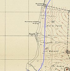
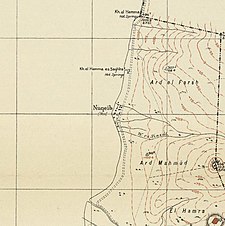 A series of historical maps of the area around Al-Nuqayb (click the buttons) | |
 Al-Nuqayb Location within Mandatory Palestine | |
| Coordinates: 32°47′57″N 35°38′25″E / 32.79917°N 35.64028°ECoordinates: 32°47′57″N 35°38′25″E / 32.79917°N 35.64028°E | |
| Palestine grid | 210/245 |
| Geopolitical entity | Mandatory Palestine |
| Subdistrict | Tiberias |
| Date of depopulation | May 14, 1948[3] |
| Area | |
| • Total | 976 dunams (97.6 ha or 241 acres) |
| Population (1945) | |
| • Total | 310[1][2] |
| Cause(s) of depopulation | Expulsion by Yishuv forces |
| Current Localities | Ein Gev[4] |


Al-Nuqayb was a Palestinian Arab village in the Tiberias Subdistrict. It was depopulated during the 1948 Arab-Israeli War on May 15, 1948. It was located 10 km east across the lake from Tiberias. bordering the Wadi al-Muzaffar and Wadi Samakh. al-Nuqayb was named after the Bedouin tribe of 'Arab al-Nuqayb.
Location[]
The village was located on the eastern shore of Lake Tiberias, with the fortress Qal'at al-Hisn located just to the east.[4]
History[]
In the 1880s most of the village land was purchased by the Bahá'u'lláh, while the villagers continued to farm as tenant farmers.[4]
British Mandate era[]
In the 1920s, the land the Bahá'u'lláh had purchased was sold to the JNF.[4] At the time of the 1922 census of Palestine conducted by the British Mandate authorities, Nuqhaib had a population of 103 Muslims,[5] increasing in the 1931 census to 287 Muslims, in 60 houses.[6]
The Kibbutz of Ein Gev was established in 1937, 1,5 km south of the village site.[4]
In 1944/1945, the village had a population of 320 Muslims,[1] with a total of 967 dunams of land.[2] Of this, 131 dunams were irrigated or used for plantations, 797 were used for cereals,[7] while 30 dunams were classified as built-up (urban) land.[8]
1948, aftermath[]
After the 1948 Palestine war, according to the armistice agreements of 1949 Between Israel and Syria, it was determined that a string of villages, including Nuqeib, Al-Hamma, Al-Samra in the Tiberias Subdistrict and Kirad al-Baqqara and Kirad al-Ghannama further north in the Safad Subdistrict, would be included the demilitarized zone (DMZ) between Israel and Syria. The villagers and their property were formally protected by Article V of the Israeli-Syrian agreement of 20 July that year.[9][10][11] However, Israel thought the villagers could pose a security threat, and Israeli settlers and settlement agencies coveted the land. Israel therefore wanted the Palestinian inhabitants, a total of 2,200 villagers, moved to Syria.[9] Most of the villagers were eventually moved to Syria, while some were "transferred" to Sha'ab.[4]
In 1992 the village site was described: "The site is fenced in and covered with thorny grass and various kinds of trees, such as Christ's-thorn trees. Piles of stones and the remains of walls can be seen. Part of the surrounding land is cultivated by the nearby settlement, and the remainder is used as a grazing area by Israelis."[4]
References[]
- ^ a b Department of Statistics, 1945, p. 12
- ^ a b Government of Palestine, Department of Statistics. Village Statistics, April, 1945. Quoted in Hadawi, 1970, p. 72
- ^ Morris, 2004, p. xvii, village #370. Also gives cause of depopulation
- ^ a b c d e f g Khalidi, 1992, p. 536
- ^ Barron, 1923, Table XI, p. 39
- ^ Mills, 1932, p. 84
- ^ Government of Palestine, Department of Statistics. Village Statistics, April, 1945. Quoted in Hadawi, 1970, p. 122
- ^ Government of Palestine, Department of Statistics. Village Statistics, April, 1945. Quoted in Hadawi, 1970, p. 172
- ^ a b Morris, 2004, p. 512
- ^ UN Doc S/1353 Syria Israel Armistice Agreement of 20 July 1949
- ^ Map
Bibliography[]
- Barron, J. B., ed. (1923). Palestine: Report and General Abstracts of the Census of 1922. Government of Palestine.
- Department of Statistics (1945). Village Statistics, April, 1945. Government of Palestine.
- Hadawi, S. (1970). Village Statistics of 1945: A Classification of Land and Area ownership in Palestine. Palestine Liberation Organization Research Center. Archived from the original on 2018-12-08. Retrieved 2009-08-18.
- Khalidi, W. (1992). All That Remains: The Palestinian Villages Occupied and Depopulated by Israel in 1948. Washington D.C.: Institute for Palestine Studies. ISBN 0-88728-224-5.
- Mills, E., ed. (1932). Census of Palestine 1931. Population of Villages, Towns and Administrative Areas. Jerusalem: Government of Palestine.
- Morris, B. (2004). The Birth of the Palestinian Refugee Problem Revisited. Cambridge University Press. ISBN 978-0-521-00967-6.
External links[]
- Welcome To al-Nuqayb
- al-Nuqayb, Zochrot
- Al-Nuqayb, from the Khalil Sakakini Cultural Center

- Arab villages depopulated during the 1948 Arab–Israeli War
- District of Tiberias