Al-Manshiyya, Tiberias
Al-Manshiyya
المنشية | |
|---|---|
Village | |
| Etymology: From personal name[1] | |
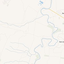
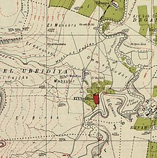 A series of historical maps of the area around Al-Manshiyya, Tiberias (click the buttons) | |
 Al-Manshiyya Location within Mandatory Palestine | |
| Coordinates: 32°41′33″N 35°33′29″E / 32.69250°N 35.55806°ECoordinates: 32°41′33″N 35°33′29″E / 32.69250°N 35.55806°E | |
| Palestine grid | 203/233 |
| Geopolitical entity | Mandatory Palestine |
| Subdistrict | Tiberias |
| Date of depopulation | March 3, 1948 |
| Current Localities | Beit Zera[2] |
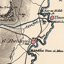
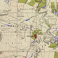

Al-Manshiyya (Arabic: المنشية) was a Palestinian Arab village in the Tiberias Subdistrict, located 11 kilometres south of Tiberias.[3] It was probably depopulated at the same time as neighbouring Al-'Ubaydiyya, in the 1947–1948 Civil War in Mandatory Palestine.[4] Manshiyya was located 0.5 km south of Umm Junieh or Khirbat Umm Juni, and the two villages were usually described together in administrative documents.[citation needed]
History[]

Ottoman period[]
In 1799, in the late Ottoman period, Um Junieh was noted as "ruins" on the map of Pierre Jacotin.[5] In 1875, Victor Guérin noted Um Junieh as a village.[6] In the PEF's Survey of Western Palestine in 1881 Umm Junieh was described as having 250 inhabitants, all Muslim.[7] They noted that it was possible that Umm Junieh was the place which Josephus called Union.[8]
In the 1880s the land of Khirbat Umm Juni and Al-Manshiyya was bought on behalf of the Bahá'u'lláh, the founder of the Baháʼí Faith. The Arab inhabitants continued to farm the land as tenant farmers.[3]
A population list from about 1887 showed that Kiryet Umm Juny had about 330 Muslim inhabitants.[9]
Degania[]
In 1905-1907 the land was resold to the Jewish National Fund. What were to become Kibbutz Degania was established at Umm Juni, in part using existing Arab-made mud huts and for a while the Arab village and the Jewish one coexisted.
British Mandate era[]
In the 1922 census of Palestine, there were 79 Muslim residents in Khirbat Umm Juneh,[10] while no number is available for Al-Manshiyya.[3][dubious ]
Post 1948[]
In 1992 the village site was described: "The site is covered with grasses and a few palm and eucalyptus trees; no traces of buildings remain. The surrounding lands are cultivated by Israelis."[2]
See also[]
- Degania Alef, the "mother of all kibbutzim", was established at Umm Junieh in 1909
References[]
- ^ Palmer, 1881, p. 136
- ^ Jump up to: a b Khalidi, 1992, p. 533
- ^ Jump up to: a b c Khalidi, 1992, p. 532
- ^ Khalidi, 1992, pp. 533-534
- ^ Karmon, 1960, p. 167 Archived 2017-12-01 at the Wayback Machine
- ^ Guérin, 1880, p. 283
- ^ Conder and Kitchener, 1881, SWP I, p.362. Quoted in Khalidi, 1992, p. 532
- ^ Conder and Kitchener, 1881, SWP I, 371
- ^ Schumacher, 1888, p. 187
- ^ Barron, 1923, Table XI, Sub-district of Tiberias, p. 39
Bibliography[]
- Barron, J. B., ed. (1923). Palestine: Report and General Abstracts of the Census of 1922. Government of Palestine.
- Conder, C.R.; Kitchener, H. H. (1881). The Survey of Western Palestine: Memoirs of the Topography, Orography, Hydrography, and Archaeology. 1. London: Committee of the Palestine Exploration Fund. (Kh. Um Juni p. 371)
- Guérin, V. (1880). Description Géographique Historique et Archéologique de la Palestine (in French). 3: Galilee, pt. 1. Paris: L'Imprimerie Nationale.
- Hadawi, S. (1970). Village Statistics of 1945: A Classification of Land and Area ownership in Palestine. Palestine Liberation Organization Research Centre. Archived from the original on 2018-12-08. Retrieved 2009-08-18.
- Karmon, Y. (1960). "An Analysis of Jacotin's Map of Palestine" (PDF). Israel Exploration Journal. 10 (3, 4): 155–173, 244–253. Archived from the original (PDF) on 2017-12-01. Retrieved 2016-08-22.
- Khalidi, W. (1992). All That Remains: The Palestinian Villages Occupied and Depopulated by Israel in 1948. Washington D.C.: Institute for Palestine Studies. ISBN 0-88728-224-5.
- Morris, B. (2004). The Birth of the Palestinian Refugee Problem Revisited. Cambridge University Press. ISBN 978-0-521-00967-6.
- Palmer, E. H. (1881). The Survey of Western Palestine: Arabic and English Name Lists Collected During the Survey by Lieutenants Conder and Kitchener, R. E. Transliterated and Explained by E.H. Palmer. Committee of the Palestine Exploration Fund.
- Schumacher, G. (1888). "Population list of the Liwa of Akka". Quarterly statement - Palestine Exploration Fund. 20: 169–191.
External links[]
- Welcome to Al-Manshiyya
- Manshiyyat Samakh, Zochrot
- Survey of Western Palestine, Map 6: IAA, Wikimedia commons

- Arab villages depopulated during the 1948 Arab–Israeli War
- District of Tiberias