Saint-Martin-de-Ré
show This article may be expanded with text translated from the corresponding article in French. (December 2008) Click [show] for important translation instructions. |
Saint-Martin-de-Ré | |
|---|---|
 The quays | |
 Coat of arms | |
show Location of Saint-Martin-de-Ré | |
 Saint-Martin-de-Ré | |
| Coordinates: 46°12′11″N 1°22′02″W / 46.2031°N 1.3672°WCoordinates: 46°12′11″N 1°22′02″W / 46.2031°N 1.3672°W | |
| Country | France |
| Region | Nouvelle-Aquitaine |
| Department | Charente-Maritime |
| Arrondissement | La Rochelle |
| Canton | Île de Ré |
| Intercommunality | Ile-de-Ré |
| Government | |
| • Mayor (2020–2026) | Patrice Déchelette[1] |
| Area 1 | 4.70 km2 (1.81 sq mi) |
| Population (Jan. 2018)[2] | 2,207 |
| • Density | 470/km2 (1,200/sq mi) |
| Time zone | UTC+01:00 (CET) |
| • Summer (DST) | UTC+02:00 (CEST) |
| INSEE/Postal code | 17369 /17410 |
| Elevation | 0–17 m (0–56 ft) (avg. 8 m or 26 ft) |
| 1 French Land Register data, which excludes lakes, ponds, glaciers > 1 km2 (0.386 sq mi or 247 acres) and river estuaries. | |


Saint-Martin-de-Ré is a commune in the western French department of Charente-Maritime.
It is one of the ten communes located on the Île de Ré.
History[]
Fortifications[]

Saint-Martin-de-Ré has extensive fortifications, reflecting the strategic importance of the Île de Ré. During the Huguenot Rebellions of the 1620s, Cardinal Richelieu ordered that the island be fortified as a counterweight to the nearby Protestant city of La Rochelle on the French mainland. This included a citadel at Saint-Martin. After La Rochelle had been subdued, Saint-Martin's fortifications were largely demolished to remove its potential threat to royal power.
In 1627, an English invasion force under the command of George Villiers, Duke of Buckingham attacked the island in order to relieve the Siege of La Rochelle. After three months of combat in the Siege of Saint-Martin-de-Ré against the French under Marshal Toiras, the Duke was forced to withdraw in defeat.
Later, in the 1670s, the French engineer, Vauban was commissioned to review and overhaul the island's defences and, as a result, Saint Martin was enclosed by extensive and modern walls and embankments. This was done in three major phases ending in 1702 and the end result was an enclosed town capable of housing the island's population for a long siege.

Prison to the penal colonies[]
Between 1873 and 1938, the prison in Saint-Martin-de-Ré kept prisoners before they were shipped to the penal colonies in French Guiana or New Caledonia. See penal colonies on Ré Island (in French).
Population[]
The population of the commune has remained steady since 1800, although it was considerably larger during the French Revolution and dipped below 2000 from the 1920s to the 1940s.
The commune is the third-largest town on the island. With La Flotte, it forms a small urban area with 5531 inhabitants in 2008, which places it as the 11th-largest metropolitan area in Charente-Maritime and the largest on the island.
|
|
Gallery[]
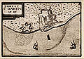
Map of Saint-Martin-de-Ré, with fortress and city, 17th century, before the enlarged fortifications of Vauban.

Map of Saint-Martin-de-Ré, after the fortifications of Vauban, 1722.


City gate in Saint-Martin

Âne en culotte donkey


Personalities[]
- Nicolas Baudin, sailor and explorer
See also[]
- Ernest Cognac Museum
- Communes of the Charente-Maritime department
References[]
- ^ "Répertoire national des élus: les maires". data.gouv.fr, Plateforme ouverte des données publiques françaises (in French). 2 December 2020.
- ^ "Populations légales 2018". INSEE. 28 December 2020.
External links[]
| Wikimedia Commons has media related to Saint-Martin-de-Ré. |
- Saint-Martin-de-Ré Tourism Office
- Île de Ré and Ernest Cognacq museums
- Vauban fortifications
- Fortified-places.com
| show Authority control |
|---|
- Communes of Charente-Maritime
- Aunis
- Vauban fortifications in France