Torontál County
This article needs additional citations for verification. (December 2009) |
| Torontál County | |
|---|---|
| County of the Kingdom of Hungary (14th century-1526) County of the Eastern Hungarian Kingdom (1526-1551) County of the Kingdom of Hungary (1551-1552) County of the Kingdom of Hungary (1779-1849, 1860-1923) | |
 Coat of arms
| |
 | |
| Capital | Aracsa; Nagy-Becskerek (1779-1807, 1820-1920); Nagyszentmikós (1807-1820); Kiszombor (1920-1923) |
| Area | |
| • Coordinates | 45°23′N 20°24′E / 45.383°N 20.400°ECoordinates: 45°23′N 20°24′E / 45.383°N 20.400°E |
• 1910 | 10,016 km2 (3,867 sq mi) |
| Population | |
• 1910 | 615151 |
| History | |
• Established | 14th century |
• Ottoman conquest | 1552 |
• County recreated | 23 April 1779 |
• Disestablished | 18 November 1849 |
• County recreated | 27 December 1860 |
• Treaty of Trianon | 4 June 1920 |
• Merged into Csanád-Arad-Torontál County | 1923 |
| Today part of | (7,261 km2)
(258 km2) |
| Vranjevo, Zrenjanin; Sânnicolau Mare is the current name of the capital. | |


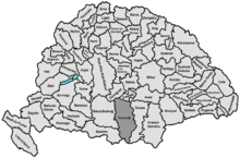
Torontál (Hungarian: Torontál, German: Torontal, Serbian: Торонтал, Romanian: Torontal) was an administrative county (comitatus) of the Kingdom of Hungary. Its territory is now divided between Serbia and Romania, except a small area which is part of Hungary. The capital of the county was Nagybecskerek (Serbian: Велики Бечкерек, German: Großbetschkerek, Romanian: Becicherecu Mare), the current Zrenjanin.
Geography[]
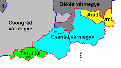
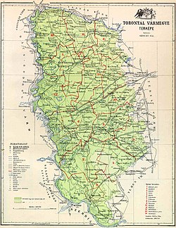
Torontál county was located in the Banat region. It shared borders with the Kingdom of Serbia and the Hungarian counties Syrmia, Bács-Bodrog, Csongrád, Csanád, Arad and Temes (the first county was part of Croatia-Slavonia). The river Danube formed its southern border, the river Tisza its western border, and the river Maros (Mureș) its northern border. Its area was 10,042 km² around 1910.
History[]
Torontál county was formed before the 15th century. Initial capital was Aracsa (Vranjevo) and existed until this area was taken by the Ottoman Empire in 1552. During Ottoman administration, this territory was included into the Ottoman Province of Temeşvar. After the Banat was captured by the Habsburg Monarchy in 1718, the area was included into the Banat of Temeswar. This province was abolished in 1778 and it was incorporated into the Habsburg Kingdom of Hungary, county was restored in 1779. Its center was moved temporarily to Nagyszentmiklós (present-day Sânnicolau Mare) between 1807 and 1820 due to a great fire in Nagybecskerek (present-day Zrenjanin).

In 1848/1849 the area of the county was claimed by the self-proclaimed Serbian Voivodship, while between 1849 and 1860 it was part of the Voivodeship of Serbia and Banat of Temeschwar, a separate Austrian crownland. After 1853, the county did not exist since the voivodeship was divided into districts. Ater the voivodeship was abolished in 1860, wthe area was again incorporated into the Habsburg Kingdom of Hungary and the county was recreated in January 1861.
In 1918, the county became part of the newly formed Banat Republic, and then part of Banat, Bačka and Baranja region of the Kingdom of Serbia, which subsequently became part of the newly formed Kingdom of Serbs, Croats and Slovenes (later renamed to Yugoslavia). By the Treaty of Trianon of 1920, the area of the county was divided between the Kingdom of Serbs, Croats and Slovenes, Romania, and Hungary. Most of the county was assigned to the Kingdom of Serbs, Croats and Slovenes (which later became Yugoslavia). The north-eastern part of the county was assigned to Romania, and the northernmost part of the county (a small area south of Szeged, Kiszombor and 8 surrounding villages) was assigned to Hungary and became part of the newly formed county Csanád-Arad-Torontál in 1923.
The Yugoslav part of the pre-1920 Torontál county (the western Banat region) is now part of Serbia (mostly in the autonomous region of Vojvodina, except the small part near Belgrade, which is part of Belgrade Region). The Romanian part is now part of Timiș county (called Timiș-Torontal between 1919 and 1950). The Hungarian part is now part of Csongrád County.
Demographics[]
1900[]
In 1900, the county had a population of 609,362 people and was composed of the following linguistic communities:[1]
Total:
- Serbian: 191,857 (31,5%)
- German: 184,016 (30,2%)
- Hungarian: 114,760 (18,8%)
- Romanian: 88,044 (14,4%)
- Slovak: 14,969 (2,5%)
- Croatian: 4,096 (0,7%)
- Ruthenian: 30 (0,0%)
- Other or unknown: 11,590 (1,9%)
According to the census of 1900, the county was composed of the following religious communities:[2]
Total:
- Roman Catholic: 284,704 (46,7%)
- Eastern Orthodox: 277,558 (45,6%)
- Lutheran: 22,524 (3,7%)
- Calvinist: 12,195 (2,0%)
- Jewish: 6,750 (1,1%)
- Greek Catholic: 3,723 (0,6%)
- Unitarian: 73 (0,0%)
- Other or unknown: 1,835 (0,3%)
1910[]
In 1910, the county had a population of 615,151 people and was composed of the following linguistic communities:[3]
Total:
- Serbian: 199,750 (32,5%)
- German: 165,779 (26,9%)
- Hungarian: 128,405 (20,9%)
- Romanian: 86,937 (14,1%)
- Slovak: 16,143 (2,6%)
- Croatian: 4,203 (0,7%)
- Ruthenian: 11 (0,1%)
- Other or unknown: 13,923 (2,3%)
According to the census of 1910, the county was composed of the following religious communities:[4]
Total:
- Eastern Orthodox: 286,642 (46,6%)
- Roman Catholic: 279,793 (45,5%)
- Lutheran: 24,905 (4,1%)
- Calvinist: 12,549 (2,0%)
- Jewish: 6,114 (1,0%)
- Greek Catholic: 3,828 (0,6%)
- Unitarian: 115 (0,0%)
- Other or unknown: 1,205 (0,2%)
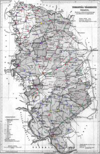
Subdivisions[]
In the early 20th century, the subdivisions of Torontál county were:
| Districts (járás) | |
|---|---|
| District | District Seat |
| Alibunári járás | Alibunár (Serbian: Алибунар), today in Serbia |
| Antalfalvai járás | Antalfalva (Serbian: Ковачица), today in Serbia |
| Bánlaki járás | Bánlak (Romanian: Banloc), today in Romania |
| Csenei járás | Csene (Romanian: Cenei), today in Romania |
| Módosi járás | Módos (Serbian: Модош), today Jaša Tomić in Serbia |
| Nagybecskereki járás | Nagy-Becskerek (Serbian: Велики Бечкерек), today Zrenjanin in Serbia |
| Nagykikindai járás | Nagy-Kikinda (Serbian: Велика Кикинда), today Kikinda in Serbia |
| Nagyszentmiklósi járás | Nagyszentmiklós (Romanian: Sânnicolau Mare), today in Romania |
| Pancsovai járás | Pancsova (Serbian: Панчево), today in Serbia |
| Párdányi járás | Párdány (Serbian: Пардањ), today Međa in Serbia |
| Perjámosi járás | Perjámos (Romanian: Periam), today in Romania |
| Törökbecsei járás | Törökbecse (Serbian: Турски Бечеј), today Novi Bečej in Serbia |
| Törökkanizsai járás | Törökkanizsa (Serbian: Турска Кањижа), today Novi Kneževac in Serbia |
| Zsombolyai járás | Zsombolya (Romanian: Jimbolia), today in Romania |
| Urban counties (törvényhatósági jogú város) | |
| Pancsova (Serbian: Панчево), today in Serbia | |
| Urban districts (rendezett tanácsú város) | |
| Nagybecskerek (Serbian: Велики Бечкерек), today in Serbia | |
| Nagykikinda (Serbian: Велика Кикинда), today in Serbia | |
See also[]
References[]
- ^ "KlimoTheca :: Könyvtár". Kt.lib.pte.hu. Retrieved 2012-06-26.
- ^ "KlimoTheca :: Könyvtár". Kt.lib.pte.hu. Retrieved 2012-06-26.
- ^ "KlimoTheca :: Könyvtár". Kt.lib.pte.hu. Retrieved 2012-06-26.
- ^ "KlimoTheca :: Könyvtár". Kt.lib.pte.hu. Retrieved 2012-06-26.

| Wikimedia Commons has media related to Torontál County. |
| Authority control |
|
|---|
- States and territories established in the 14th century
- States and territories established in 1779
- States and territories established in 1860
- States and territories disestablished in 1552
- States and territories disestablished in 1849
- States and territories disestablished in 1920
- States and territories disestablished in 1923
- Counties in the Kingdom of Hungary
- Vojvodina under Habsburg rule
- History of Banat
- Hungary under Habsburg rule