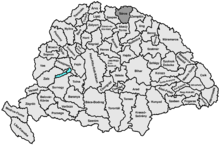
Sáros County
| Sáros County | |
|---|---|
| County of the Kingdom of Hungary | |
| 13th century–1920 | |
 Coat of arms
| |
 | |
| Capital | Eperjes |
| Area | |
| • Coordinates | 49°0′N 21°14′E / 49.000°N 21.233°ECoordinates: 49°0′N 21°14′E / 49.000°N 21.233°E |
• 1910 | 3,652 km2 (1,410 sq mi) |
| Population | |
• 1910 | 174600 |
| History | |
• Established | 13th century |
• Treaty of Trianon | 4 June 1920 |
| Today part of | |
| Prešov is the current name of the capital. | |

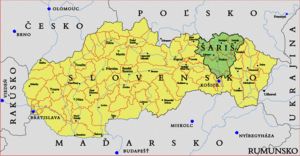
Sáros (-Hungarian, Slovak: Šariš, Latin: comitatus Sarossiensis, German: Scharosch) was an administrative county (comitatus) of the Kingdom of Hungary. Its territory is now in northeastern Slovakia. Today, Šariš is only an informal designation of the corresponding territory.
Geography[]

Sáros county shared borders with the Austrian crownland Galicia and the Hungarian counties Szepes, Abaúj-Torna and Zemplén. It was situated between the Levoča Hills (i.e., Szepesség (Spiš)), Kassa and Felső-Szvidnyik. The river Tarca flowed through the county. Its area was 3,652 km² around 1910.
Capitals[]
The capital of Sáros county was Sáros Castle. After various other towns, since 1647 the capital has been Eperjes.
History[]
Sáros county was created in the 13th century from the comitatus Novi Castri (Újvár County, named after Novum Castrum, today Abaújvár) which included also the territories of the later counties of Abaúj and Heves.
In the aftermath of World War I, most of Sáros county became part of newly formed Czechoslovakia, as recognized by the concerned states in the 1920 Treaty of Trianon. During World War II, when Czechoslovakia was divided, Šariš became part of the First Slovak Republic. Since 1993, Šariš has been part of Slovakia, located in the Prešov Region. Historically a prosperous region, it is nowadays relatively poor.
Demographics[]
1900[]
In 1900, the county had a population of 174,470 people and was composed of the following linguistic communities:[1]
Total:
- Slovak: 115,141 (66.0%)
- Ruthenian: 33,988 (19.5%)
- Hungarian: 10,926 (6.3%)
- German: 10,886 (6.2%)
- Croatian: 63 (0.0%)
- Romanian: 33 (0.0%)
- Serbian: 5 (0.0%)
- Other or unknown: 3,428 (2.0%)
According to the census of 1900, the county was composed of the following religious communities:[2]
Total:
- Roman Catholic: 93,753 (53.8%)
- Greek Catholic: 53,434 (30.6%)
- Lutheran: 14,494 (8.3%)
- Jewish: 12,262 (7.0%)
- Calvinist: 487 (0.3%)
- Greek Orthodox: 28 (0.0%)
- Unitarian: 6 (0.0%)
- Other or unknown: 6 (0.0%)
1910[]

In 1910, the county had a population of 174,620 people and was composed of the following linguistic communities:[3]
Total:
- Slovak: 101,855 (58.3%)
- Ruthenian: 38,500 (22.0%)
- Hungarian: 18,088 (10.4%)
- German: 9,447 (5.4%)
- Romanian: 321 (0.2%)
- Croatian: 15 (0.0%)
- Serbian: 2 (0.0%)
- Other or unknown: 6,392 (3.7%)
According to the census of 1910, the county was composed of the following religious communities:[4]
Total:
- Roman Catholic: 94,223 (54.0%)
- Greek Catholic: 52,938 (30.3%)
- Lutheran: 14,224 (8.1%)
- Jewish: 12,323 (7.1%)
- Calvinist: 838 (0.5%)
- Greek Orthodox: 61 (0.0%)
- Unitarian: 12 (0.0%)
- Other or unknown: 1 (0.0%)
Subdivisions[]

In the early 20th century, the subdivisions of Sáros county were:
| Districts (járás) | |
|---|---|
| District | Capital |
| Bártfa | Bártfa (now Bardejov) |
| Eperjes | Eperjes (now Prešov) |
| Felsővízköz | Felsővízköz (now Svidník) |
| Girált | Girált (now Giraltovce |
| Héthárs | Héthárs (now Lipany) |
| Kisszeben | Kisszeben (now Sabinov) |
| Lemes | Lemes (now Lemešany) |
| Urban districts (rendezett tanácsú város) | |
| Bártfa (now Bardejov) | |
| Eperjes (now Prešov) | |
| Kisszeben (now Sabinov) | |
References[]
- ^ "KlimoTheca :: Könyvtár". Kt.lib.pte.hu. Retrieved 26 June 2012.
- ^ "KlimoTheca :: Könyvtár". Kt.lib.pte.hu. Retrieved 26 June 2012.
- ^ "KlimoTheca :: Könyvtár". Kt.lib.pte.hu. Retrieved 26 June 2012.
- ^ "KlimoTheca :: Könyvtár". Kt.lib.pte.hu. Retrieved 26 June 2012.

- States and territories established in the 13th century
- States and territories disestablished in 1920
- Counties in the Kingdom of Hungary