Varaždin County (former)
| Varaždin County Varaždinska županija Varasd vármegye | |
|---|---|
| County of the Kingdom of Croatia-Slavonia | |
| 1868–1920 | |
 Coat of arms
| |
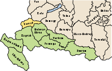 Location of the County (yellow) within the Kingdom of Croatia-Slavonia (green) | |
| Capital | Varaždin |
| Area | |
| • Coordinates | 46°18′N 16°20′E / 46.300°N 16.333°ECoordinates: 46°18′N 16°20′E / 46.300°N 16.333°E |
• 1910 | 2,521 km2 (973 sq mi) |
| Population | |
• 1910 | 307010 |
| History | |
• Established | 1868 |
• Treaty of Trianon | June 4 1920 |
| Today part of | Croatia |

Varaždin County (Croatian: Varaždinska županija; Hungarian: Varasd vármegye) was an administrative subdivision (županija) of the Kingdom of Croatia-Slavonia. Croatia-Slavonia was an autonomous kingdom within the Lands of the Crown of Saint Stephen (Transleithania), the Hungarian part of the dual Austro-Hungarian Empire. Its territory is now in northern Croatia. The capital of the county was Varaždin (Croatian, in Hungarian: Varasd).[1]
Geography[]
Varaždin County shared borders with the Austrian land Styria, the Hungarian county of Zala, and the Croatian-Slavonian county of Bjelovar-Križevci and Zagreb. The river Drava formed its northern border.[2] Its area was 2521 km² around 1910.
History[]
The territory of the Varaždin County was part of the Kingdom of Croatia when it entered a personal union with the Kingdom of Hungary in 1102, and with it became part of the Habsburg Monarchy in 1526. It was part of the Varaždin Generalate of the Military Frontier. After 1607, the position of the County's župan was hereditary, given to the Erdődy noble family.[3]
In 1920, by the Treaty of Trianon the county became part of the newly formed Kingdom of Serbs, Croats and Slovenes (later renamed to Yugoslavia). Since 1991, when Croatia became independent from Yugoslavia, the county is part of the Republic of Croatia.[4]
Demographics[]
In 1900, the county had a population of 279,448 people and was composed of the following linguistic communities:[5]
Total:
- Croatian: 270,897 (96.9%)
- Serbian: 2,464 (0.9%)
- German: 1,654 (0.6%)
- Hungarian: 1,061 (0.4%)
- Slovak: 126 (0.0%)
- Ruthenian: 4 (0.0%)
- Romanian: 1 (0.0%)
- Other or unknown: 3,241 (1.2%)
According to the census of 1900, the county was composed of the following religious communities:[6]
Total:
- Roman Catholic: 275,111 (98.5%)
- Serbian Orthodox: 2,502 (0.9%)
- Jewish: 1,612 (0.6%)
- Lutheran: 161 (0.0%)
- Calvinist: 31 (0.0%)
- Greek Catholic: 26 (0.0%)
- Unitarian: 0 (0.0%)
- Other or unknown: 5 (0.0%)
In 1910, the county had a population of 307,010 people and was composed of the following linguistic communities:[7]
Total:
- Croatian: 300,033 (97.7%)
- Serbian: 2,384 (0.8%)
- German: 1,172 (0.4%)
- Hungarian: 1,095 (0.4%)
- Slovak: 41 (0.0%)
- Ruthenian: 0 (0.0%)
- Romanian: 2 (0.0%)
- Other or unknown: 2,283 (0.7%)
According to the census of 1910, the county was composed of the following religious communities:[8]
Total:
- Roman Catholic: 303,038 (98.7%)
- Serbian Orthodox: 2,409 (0.8%)
- Jewish: 1,341 (0.4%)
- Lutheran: 114 (0.0%)
- Calvinist: 42 (0.0%)
- Greek Catholic: 61 (0.0%)
- Unitarian: 0 (0.0%)
- Other or unknown: 5 (0.0%)
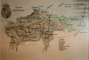
Subdivisions[]
In the early 20th century, the subdivisions of Varasd county were:
| Districts | |
|---|---|
| District | Capital |
| Ivanec | Ivanec |
| Klanjec | Klanjec |
| Krapina | Krapina |
| Ludbreg | Ludbreg |
| Novi Marof | Novi Marof |
| Pregrada | Pregrada |
| Varasd | Varaždin |
| Zlatar | Zlatar |
| Urban counties | |
| Varaždin | |
See also[]
- Current Varaždin County
Notes[]
- ^ Oliver, Jeanne (January 1, 2007). Croatia. Lonely Planet. ISBN 9781741044751.
- ^ Abraham, Rudolf (January 1, 2011). National Geographic Traveler: Croatia. National Geographic Society. ISBN 9781426207099.
- ^ Ivana Horbec (September 2010). "Slavonske županije između Banske Hrvatske i Mađarske: uspostava civilne uprave i pitanje poreznog sustava u 18. stoljeću" [Slavonia between Croatian and Hungarian kingdom: The establishment of county administration and the tax system issue in the 18th century]. Arhivski vjesnik (in Croatian). Croatian State Archives (53): 180. Retrieved September 7, 2012.
- ^ Ethnic Groups and Population Changes in Twentieth-Century Central-Eastern Europe. M.E. Sharpe. ISBN 9780765618337.
- ^ "KlimoTheca :: Könyvtár". Kt.lib.pte.hu. Retrieved December 6, 2012.
- ^ "KlimoTheca :: Könyvtár". Kt.lib.pte.hu. Retrieved December 6, 2012.
- ^ "KlimoTheca :: Könyvtár". Kt.lib.pte.hu. Retrieved December 6, 2012.
- ^ "KlimoTheca :: Könyvtár". Kt.lib.pte.hu. Retrieved December 6, 2012.
| show Counties of the Lands of the Crown of Saint Stephen |
|---|

| show Authority control |
|---|
- States and territories established in 1868
- States and territories disestablished in 1920
- Varaždin County (former)
- 1920 disestablishments
- Former counties of Croatia
- Counties in the Kingdom of Hungary
- States and territories established in the 12th century