Ugocsa County
This article needs additional citations for verification. (December 2009) |
| Ugocsa County | |
|---|---|
| County of the Kingdom of Hungary (14th century-1544) County of the Eastern Hungarian Kingdom (1544-1561) County of the Kingdom of Hungary (1561-1606) County of the Principality of Transylvania (1606-1606) County of the Kingdom of Hungary (1606-1621) County of the Principality of Transylvania (1621-1629) County of the Kingdom of Hungary (1629-1645) County of the Principality of Transylvania (1645-1648) County of the Kingdom of Hungary (1648-1785, 1790-1850, 1860-1920, 1940-1945) | |
 Coat of arms
| |
 | |
| Capital | Nagyszőllős |
| Area | |
| • Coordinates | 48°8′N 23°2′E / 48.133°N 23.033°ECoordinates: 48°8′N 23°2′E / 48.133°N 23.033°E |
• 1910 | 1,213 km2 (468 sq mi) |
| Population | |
• 1910 | 91755 |
| History | |
• Established | 14th century |
• Merged into Bereg-Ugocsa County | 1785 |
• County recreated | 1790 |
• Merged into Bereg County | 1850 |
• County recreated | 1860 |
• Treaty of Trianon | 4 June 1920 |
• Merged into Szatmár-Ugocsa-Bereg County | 1923 |
• Merged into Bereg-Ugocsa County (First Vienna Award) | 2 November 1938 |
• County recreated (Second Vienna Award) | 30 August 1940 |
• Merged into Szatmár-Bereg County | 1945 |
| Today part of | |
| Vynohradiv is the current name of the capital. | |

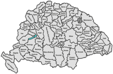
Ugocsa was an administrative county (comitatus) of the Kingdom of Hungary. Its territory is now in north-western Romania (1/4) and western Ukraine (3/4). The capital of the county was Nagyszőllős (now Vynohradiv, Ukraine).
Geography[]

Ugocsa county shared borders with the Hungarian counties Máramaros, Szatmár and Bereg. It was situated on both sides of the river Tisza. Its area was 1208 km² around 1910.
History[]
In 1920, by the Treaty of Trianon most of the county (including Nagyszőllős) became part of newly formed Czechoslovakia, while a very little part remained in Hungary were joined to Szatmár County, which was merged to Szatmár-Ugocsa-Bereg County in 1923. The southern part - including Halmi (today Halmeu) - became part of Romania. In 1938, the western part of the former Czechoslovak part was returned to Hungary by the First Vienna Award, which became part of the newly formed Bereg-Ugocsa County - as Szatmár County was recreated -, however shortly in 1939 the rest became part of Hungary again as the remainder of Carpathian Ruthenia was annexed after Czechoslovakia ceased to exist. These part were assigned to the administrative branch offices of Máramaros. In 1940, by the Second Vienna Award the southern part as well returned to Hungary thus the county was recreated with a modified territory, with the parts also included earlier to the administrative branch offices of Máramaros. The capital became again Nagyszőllős.
After World War II, the formerly Czechoslovak part of Ugocsa county became part of the Soviet Union, Ukrainian SSR, Zakarpattia Oblast. Since 1991, when the Soviet Union split up, the Zakarpattia Oblast is part of Ukraine. The southern part of the county became part of Romania again and is now part of the Romanian county Satu Mare.
Demographics[]
1900[]
In 1900, the county had a population of 83,316 people and was composed of the following linguistic communities:[1]
Total:
- Hungarian: 35,702 (42.9%)
- Ruthenian: 32,721 (39.3%)
- Romanian: 9,270 (11.1%)
- German: 5,505 (6.6%)
- Slovak: 16 (0.0%)
- Croatian: 3 (0.0%)
- Serbian: 1 (0.0%)
- Other or unknown: 98 (0.1%)
According to the census of 1900, the county was composed of the following religious communities:[2]
Total:
- Greek Catholic: 52,417 (62.9%)
- Calvinist: 12,928 (15.5%)
- Jewish: 10,556 (12.7%)
- Roman Catholic: 7,264 (8.7%)
- Lutheran: 108 (0.2%)
- Greek Orthodox: 14 (0.0%)
- Unitarian: 10 (0.0%)
- Other or unknown: 9 (0.0%)
1910[]

In 1910, the county had a population of 91,755 people and was composed of the following linguistic communities:[3]
Total:
- Hungarian: 42,677 (46.51%)
- Ruthenian: 34,415 (37.51%)
- Romanian: 9,750 (10.63%)
- German: 4,632 (5.05%)
- Slovak: 37 (0.04%)
- Croatian: 4 (0.0%)
- Serbian: 1 (0.0%)
- Other or unknown: 239 (0.26%)
According to the census of 1910, the county was composed of the following religious communities:[4]
Total:
- Greek Catholic: 57,550 (62.72%)
- Calvinist: 14,002 (15.26%)
- Jewish: 11,850 (12.91%)
- Roman Catholic: 8,173 (8.91%)
- Lutheran: 120 (0.13%)
- Greek Orthodox: 48 (0.05%)
- Unitarian: 8 (0.01%)
- Other or unknown: 4 (0.0%)
Subdivisions[]
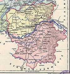
In the early 20th century, the subdivisions of Ugocsa county were:
| Districts (járás) | |
|---|---|
| District | Capital |
| Tiszáninnen | Nagyszőllős (now Vynohradiv) |
| Tiszántúl | Halmi (now Halmeu) |
Vynohradiv is now in Ukraine; Halmeu is now in Romania.
References[]
- ^ "KlimoTheca :: Könyvtár". Kt.lib.pte.hu. Retrieved June 26, 2012.
- ^ "KlimoTheca :: Könyvtár". Kt.lib.pte.hu. Retrieved June 26, 2012.
- ^ "KlimoTheca :: Könyvtár". Kt.lib.pte.hu. Retrieved June 26, 2012.
- ^ "KlimoTheca :: Könyvtár". Kt.lib.pte.hu. Retrieved June 26, 2012.

| Authority control |
|
|---|
- States and territories established in the 14th century
- States and territories established in 1790
- States and territories established in 1860
- States and territories established in 1940
- States and territories disestablished in 1785
- States and territories disestablished in 1850
- States and territories disestablished in 1920
- States and territories disestablished in 1923
- States and territories disestablished in 1945
- Counties in the Kingdom of Hungary
- Maramureș