Tramezaïgues
Tramezaïgues | |
|---|---|
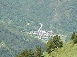 Tramezaïgues village seen from the Cap de Laubère, at 2200 meters | |
 Coat of arms | |
show Location of Tramezaïgues | |
 Tramezaïgues | |
| Coordinates: 42°47′53″N 0°17′24″E / 42.7981°N 0.29°ECoordinates: 42°47′53″N 0°17′24″E / 42.7981°N 0.29°E | |
| Country | France |
| Region | Occitanie |
| Department | Hautes-Pyrénées |
| Arrondissement | Bagnères-de-Bigorre |
| Canton | Neste, Aure et Louron |
| Government | |
| • Mayor (2008–2014) | Gérard Palasset |
| Area 1 | 34.96 km2 (13.50 sq mi) |
| Population (Jan. 2018)[1] | 35 |
| • Density | 1.0/km2 (2.6/sq mi) |
| Time zone | UTC+01:00 (CET) |
| • Summer (DST) | UTC+02:00 (CEST) |
| INSEE/Postal code | 65450 /65170 |
| Elevation | 913–2,935 m (2,995–9,629 ft) (avg. 950 m or 3,120 ft) |
| 1 French Land Register data, which excludes lakes, ponds, glaciers > 1 km2 (0.386 sq mi or 247 acres) and river estuaries. | |


Tramezaïgues (French pronunciation: [tʁamza.iɡ], official name[2]) or Tramezaygues (local name) is a commune in the Hautes-Pyrénées department, in the Occitanie region of France.
Geography[]

The commune of Tramezaïgues, in the south of the Hautes-Pyrénées department, extends from the to the Spanish border.
The village is located at the foot of 2,548 m (8,360 ft), and at the confluence of the Neste d'Aure and the . The name of Tramezaïgues is derived from the Latin description: inter ambas aquas (between two waters).
To the north of the village is the Pla d'Adet ski resort, and Aragnouet is to the west. East of the village is Loudenvielle and the Col de Val Louron-Azet. Cadeilhan-Trachère and Saint-Lary-Soulan are situated to the north-east. The Spanish border is to the south of the village.
History[]

The Château de Tramezaygues has been existent since the 12th century. The château was a position for monitoring the Spanish border until the French Revolution.
Sites and monuments[]
- The ruins of the 12th Century Château de Tramezaygues, restored in 1990 is a listed historic monument since 1980.
- The Saint-Denis Saint-Nicolas Church, of which survives the original apse of Romanesque style. The rest of the church was modified during the 16th, 17th and 19th centuries.
Politics and administration[]
| Period | Name | Label | Quality |
|---|---|---|---|
| March 2001 - current | Gérard Palasset |
Demographics[]
In 2017, the commune had 34 inhabitants.
Gallery[]

Panorama from Tramezaïgues Valley
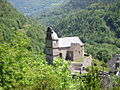
The church of Tramezaïgues

The town hall

The narrow streets of the village of Tramezaïgues

The fountain of the village

The village wash-house

A village entry sign

Street sign in the village


See also[]
References[]
- ^ "Populations légales 2018". INSEE. 28 December 2020.
- ^ "Code officiel géographique - Fiche de la commune de Tramezaïgues". Insee. Retrieved 13 July 2014.
| Wikimedia Commons has media related to Tramezaïgues. |
This Hautes-Pyrénées geographical article is a stub. You can help Wikipedia by . |
- Communes of Hautes-Pyrénées
- Hautes-Pyrénées geography stubs