Viella, Hautes-Pyrénées
Viella | |
|---|---|
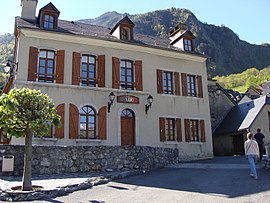 The town hall | |
 Coat of arms | |
show Location of Viella | |
 Viella | |
| Coordinates: 42°52′40″N 0°00′54″E / 42.8778°N 0.015°ECoordinates: 42°52′40″N 0°00′54″E / 42.8778°N 0.015°E | |
| Country | France |
| Region | Occitanie |
| Department | Hautes-Pyrénées |
| Arrondissement | Argelès-Gazost |
| Canton | La Vallée des Gaves |
| Government | |
| • Mayor (2020–2026) | Jean-Pierre Cots[1] |
| Area 1 | 3.14 km2 (1.21 sq mi) |
| Population (Jan. 2018)[2] | 86 |
| • Density | 27/km2 (71/sq mi) |
| Time zone | UTC+01:00 (CET) |
| • Summer (DST) | UTC+02:00 (CEST) |
| INSEE/Postal code | 65463 /65120 |
| Elevation | 772–1,987 m (2,533–6,519 ft) (avg. 800 m or 2,600 ft) |
| 1 French Land Register data, which excludes lakes, ponds, glaciers > 1 km2 (0.386 sq mi or 247 acres) and river estuaries. | |


Viella (French pronunciation: [vjɛla]; Occitan: Vielar) is a commune in the Hautes-Pyrénées department in south-western France.
See also[]
References[]
- ^ "Répertoire national des élus: les maires". data.gouv.fr, Plateforme ouverte des données publiques françaises (in French). 2 December 2020.
- ^ "Populations légales 2018". INSEE. 28 December 2020.
| Wikimedia Commons has media related to Viella (Hautes-Pyrénées). |
This Hautes-Pyrénées geographical article is a stub. You can help Wikipedia by . |
Categories:
- Communes of Hautes-Pyrénées
- Hautes-Pyrénées geography stubs