Villeneuve, Alpes-de-Haute-Provence
show This article may be expanded with text translated from the corresponding article in French. (December 2008) Click [show] for important translation instructions. |
Villeneuve | |
|---|---|
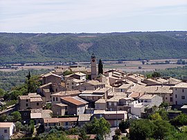 The church and surrounding buildings in Villeneuve | |
 Coat of arms | |
show Location of Villeneuve | |
 Villeneuve | |
| Coordinates: 43°53′42″N 5°51′49″E / 43.895°N 5.8636°ECoordinates: 43°53′42″N 5°51′49″E / 43.895°N 5.8636°E | |
| Country | France |
| Region | Provence-Alpes-Côte d'Azur |
| Department | Alpes-de-Haute-Provence |
| Arrondissement | Forcalquier |
| Canton | Oraison |
| Intercommunality | CA Durance-Lubéron-Verdon |
| Government | |
| • Mayor (2020–2026) | Serge Faudrin[1] |
| Area 1 | 25.55 km2 (9.86 sq mi) |
| Population (Jan. 2018)[2] | 4,259 |
| • Density | 170/km2 (430/sq mi) |
| Time zone | UTC+01:00 (CET) |
| • Summer (DST) | UTC+02:00 (CEST) |
| INSEE/Postal code | 04242 /04180 |
| Elevation | 313–600 m (1,027–1,969 ft) (avg. 450 m or 1,480 ft) |
| 1 French Land Register data, which excludes lakes, ponds, glaciers > 1 km2 (0.386 sq mi or 247 acres) and river estuaries. | |


Villeneuve (French pronunciation: [vilnœv] (![]() listen); Occitan: Vilanòva) is a commune in the Alpes-de-Haute-Provence department in southeastern France.
listen); Occitan: Vilanòva) is a commune in the Alpes-de-Haute-Provence department in southeastern France.
Villeneuve is located in Durance valley. This village, like many other villages in Provence, is built on the top of a hill to keep it protected from invaders. Villeneuve in French mean "New town" but was constructed in Middle Ages, originally further in the forest on the top of a high cliff. Only the little chapel remains on the rock to show where the original village was located.
Population[]
|
|
See also[]
References[]
- ^ "Répertoire national des élus: les maires". data.gouv.fr, Plateforme ouverte des données publiques françaises (in French). 2 December 2020.
- ^ "Populations légales 2018". INSEE. 28 December 2020.
| Wikimedia Commons has media related to Villeneuve, Alpes-de-Haute-Provence. |
| Authority control |
|
|---|
This Alpes-de-Haute-Provence geographical article is a stub. You can help Wikipedia by . |
Categories:
- Communes of Alpes-de-Haute-Provence
- Alpes-de-Haute-Provence geography stubs