Al-Malkiyya
Al-Malikiyya
المالكية Malikiya, al | |
|---|---|
 al-Malikiyya May 1948 | |
| Etymology: from "Malek": to possess, or reign[1] | |
 A series of historical maps of the area around Al-Malkiyya (click the buttons) | |
 Al-Malikiyya Location within Mandatory Palestine | |
| Coordinates: 33°06′19″N 35°30′29″E / 33.10528°N 35.50806°ECoordinates: 33°06′19″N 35°30′29″E / 33.10528°N 35.50806°E | |
| Palestine grid | 197/278 |
| Geopolitical entity | Mandatory Palestine |
| Subdistrict | Safad |
| Date of depopulation | 28 May 1948[4] |
| Area | |
| • Total | 7,328 dunams (7.328 km2 or 2.829 sq mi) |
| Population (1945) | |
| • Total | 360[2][3] |
| Cause(s) of depopulation | Military assault by Yishuv forces |
| Current Localities | Malkiya[5][6] |


Al-Malikiyya (Arabic: المالكية) was a Palestinian village located in the Jabal Amil region. In a 1920s census, the village was registered as part of Greater Lebanon. It was later placed under the British Mandate of Palestine. Its population was mostly Metawali Shiite.
In a 1930s census, the village was registered as Palestinian and part of the Safed District. The village was depopulated as a result of the 1948 Arab–Israeli War.
History[]
According to the Arab geographer Yaqut al-Hamawi (d. 1228), the people of al-Malikiyya had a wooden platter that they believed was originally owned by the prophet Mohammed.[6][7]
Ottoman era[]
In 1596, al-Malikiyya was a village in the Ottoman nahiya (subdistrict) of Tibnin under the liwa' (district) of Safad, with a population of 369. It paid taxes on a number of crops, such as wheat, barley, as well as goats and beehives.[8][9]
Victor Guérin visited in 1875, and noted that Al-Malkiyya had 300 Metawali inhabitants.[10] He further noted that the village, which stood upon a lofty summit, was remarkable for possessing neither well nor cistern; the women fetched their water from the spring at Kades. But a birkeh was placed on the map close to the village.[11]
In 1881, the PEF's Survey of Western Palestine (SWP) described Al-Malkiyya as being built of stone and adobe, lying on a plain to the east of a valley. Well supplied with water from a nearby wadi, the village's 200-300 inhabitants cultivated olives.[12]
British Mandate era[]
In the 1931 census of Palestine, conducted by the British Mandate authorities, El Malikiya had a population of 254, all Muslims, in 48 houses.[13]
The population was 360 Muslims in the 1945 statistics,[2] with a total of 7,328 dunams of land.[3] A total of 4,225 dunums were allocated to cereals,[14] while 55 dunams were classifies as built-up land.[15]
1948 Arab-Israeli war, aftermath[]
Al-Malikiyya changed hands no fewer than five times between May and October 1948.[6]
A battle was fought in the village on 5–6 June 1948. Combatants were Israelis and the Lebanese army commanded by then Lebanese minister of defense, Emir Majid Arslan II. The Lebanese army would occupy the village for a month. This was the only time Lebanon directly participated in the war.[16]
As a result of the war, the village was depopulated.
In 1949, a kibbutz, Malkiya, was set up on village lands.

Members of the Yiftach Brigade entering al-Malikiyya, May 1948
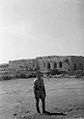
Al Malikiyya, 1948. Medic from Yiftach Brigade in foreground


See also[]
References[]
- ^ Palmer, 1881, p. 88
- ^ Jump up to: a b Department of Statistics, 1945, p. 10
- ^ Jump up to: a b c Government of Palestine, Department of Statistics. Village Statistics, April, 1945. Quoted in Hadawi, 1970, p. 70 Archived 2015-09-24 at the Wayback Machine
- ^ Morris, 2004, p. xvi, village #25. Also gives cause of depopulation.
- ^ Morris, 2004, p. xxii, Settlement #135, established 1949.
- ^ Jump up to: a b c Khalidi, 1992, p. 471
- ^ Mu'jam Al-Buldan, cited in le Strange, 1890, p.77
- ^ Hütteroth and Abdulfattah, 1977, p. 179. Quoted in Khalidi, 1992, p. 471
- ^ Note that Rhode, 1979, p. 6 writes that the register that Hütteroth and Abdulfattah studied was not from 1595/6, but from 1548/9
- ^ Guérin, 1880, p. 373
- ^ Guérin, 1880, p. 373, as given in Conder and Kitchener, 1881, SWP I, p. 251
- ^ Conder and Kitchener, 1881, SWP I, p. 202; Quoted in Khalidi, 1992, p. 471
- ^ Mills, 1932, p. 108
- ^ Government of Palestine, Department of Statistics. Village Statistics, April, 1945. Quoted in Hadawi, 1970, p. 119 Archived 2015-09-24 at the Wayback Machine
- ^ Government of Palestine, Department of Statistics. Village Statistics, April, 1945. Quoted in Hadawi, 1970, p. 170
- ^ Morris, 2004, p. 276
Bibliography[]
- Conder, C.R.; Kitchener, H.H. (1881). The Survey of Western Palestine: Memoirs of the Topography, Orography, Hydrography, and Archaeology. 1. London: Committee of the Palestine Exploration Fund.
- Department of Statistics (1945). Village Statistics, April, 1945. Government of Palestine.
- Guérin, V. (1880). Description Géographique Historique et Archéologique de la Palestine (in French). 3: Galilee, pt. 2. Paris: L'Imprimerie Nationale.
- Hadawi, S. (1970). Village Statistics of 1945: A Classification of Land and Area ownership in Palestine. Palestine Liberation Organization Research Center. Archived from the original on 2018-12-08. Retrieved 2009-07-25.
- Hütteroth, Wolf-Dieter; Abdulfattah, Kamal (1977). Historical Geography of Palestine, Transjordan and Southern Syria in the Late 16th Century. Erlanger Geographische Arbeiten, Sonderband 5. Erlangen, Germany: Vorstand der Fränkischen Geographischen Gesellschaft. ISBN 3-920405-41-2.
- Khalidi, W. (1992). All That Remains:The Palestinian Villages Occupied and Depopulated by Israel in 1948. Washington D.C.: Institute for Palestine Studies. ISBN 0-88728-224-5.
- Mills, E., ed. (1932). Census of Palestine 1931. Population of Villages, Towns and Administrative Areas. Jerusalem: Government of Palestine.
- Morris, B. (2004). The Birth of the Palestinian Refugee Problem Revisited. Cambridge University Press. ISBN 978-0-521-00967-6.
- Palmer, E.H. (1881). The Survey of Western Palestine: Arabic and English Name Lists Collected During the Survey by Lieutenants Conder and Kitchener, R. E. Transliterated and Explained by E.H. Palmer. Committee of the Palestine Exploration Fund.
- Rhode, H. (1979). Administration and Population of the Sancak of Safed in the Sixteenth Century. Columbia University.
- Stepansky, Yosef (2004-06-02). "Malkiyya (East) Final Report" (116). Hadashot Arkheologiyot – Excavations and Surveys in Israel. Cite journal requires
|journal=(help) - Strange, le, G. (1890). Palestine Under the Moslems: A Description of Syria and the Holy Land from A.D. 650 to 1500. Committee of the Palestine Exploration Fund.
External links[]
- Welcome to al-Malikiyya
- al-Malikiyya, Zochrot
- al-Malikiyya, Dr. Khalil Rizk.
- Survey of Western Palestine, Map 4: IAA, Wikimedia commons
- al-Malikiyya, from the Khalil Sakakini Cultural Center

- Arab villages depopulated during the 1948 Arab–Israeli War
- District of Safad