Alzon
Alzon | |
|---|---|
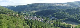 A general view of Alzon | |
 Coat of arms | |
show Location of Alzon | |
 Alzon | |
| Coordinates: 43°58′04″N 3°26′25″E / 43.9678°N 3.4403°ECoordinates: 43°58′04″N 3°26′25″E / 43.9678°N 3.4403°E | |
| Country | France |
| Region | Occitanie |
| Department | Gard |
| Arrondissement | Le Vigan |
| Canton | Le Vigan |
| Intercommunality | Pays Viganais |
| Government | |
| • Mayor (2020–2026) | Roger Laurens[1] |
| Area 1 | 27.48 km2 (10.61 sq mi) |
| Population (Jan. 2018)[2] | 172 |
| • Density | 6.3/km2 (16/sq mi) |
| Time zone | UTC+01:00 (CET) |
| • Summer (DST) | UTC+02:00 (CEST) |
| INSEE/Postal code | 30009 /30770 |
| Elevation | 502–1,414 m (1,647–4,639 ft) (avg. 600 m or 2,000 ft) |
| 1 French Land Register data, which excludes lakes, ponds, glaciers > 1 km2 (0.386 sq mi or 247 acres) and river estuaries. | |


Alzon (French pronunciation: [alzɔ̃]) is a commune in the Gard department in southern France.
The commune is located in the south of the Cévennes National Park, in the upper Vis river valley.
Population[]
|
|
Sights[]
See also[]
- Communes of the Gard department
References[]
- ^ "Répertoire national des élus: les maires". data.gouv.fr, Plateforme ouverte des données publiques françaises (in French). 2 December 2020.
- ^ "Populations légales 2018". INSEE. 28 December 2020.
| Wikimedia Commons has media related to Alzon. |
| show Communes of the Gard department |
|---|
| show Authority control |
|---|
This Gard geographical article is a stub. You can help Wikipedia by . |
Categories:
- Communes of Gard
- Gard geography stubs