Andancette
Andancette | |
|---|---|
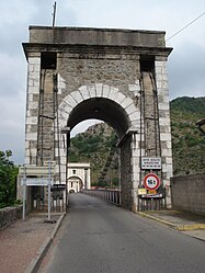 The Marc Seguin suspension bridge over the Rhône | |
 Coat of arms | |
show Location of Andancette | |
 Andancette | |
| Coordinates: 45°14′34″N 4°48′27″E / 45.2427°N 4.8075°ECoordinates: 45°14′34″N 4°48′27″E / 45.2427°N 4.8075°E | |
| Country | France |
| Region | Auvergne-Rhône-Alpes |
| Department | Drôme |
| Arrondissement | Valence |
| Canton | Saint-Vallier |
| Intercommunality | |
| Government | |
| • Mayor (2020–2026) | Frédéric Chenevier[1] |
| Area 1 | 5.98 km2 (2.31 sq mi) |
| Population (Jan. 2018)[2] | 1,346 |
| • Density | 230/km2 (580/sq mi) |
| Time zone | UTC+01:00 (CET) |
| • Summer (DST) | UTC+02:00 (CEST) |
| INSEE/Postal code | 26009 /26140 |
| Elevation | 129–168 m (423–551 ft) (avg. 138 m or 453 ft) |
| 1 French Land Register data, which excludes lakes, ponds, glaciers > 1 km2 (0.386 sq mi or 247 acres) and river estuaries. | |


Andancette (French pronunciation: [ɑ̃dɑ̃sɛt]) is a commune in the Drôme department in southeastern France.
Geography[]
Andancette is located:
- 6 km (3.7 mi) from Saint-Rambert-d'Albon
- 6 km (3.7 mi) from Saint-Vallier
- 30 km (19 mi) from Valence
Population[]
|
|
See also[]
References[]
- ^ "Répertoire national des élus: les maires". data.gouv.fr, Plateforme ouverte des données publiques françaises (in French). 2 December 2020.
- ^ "Populations légales 2018". INSEE. 28 December 2020.
| Wikimedia Commons has media related to Andancette. |
This Drôme geographical article is a stub. You can help Wikipedia by . |
Categories:
- Communes of Drôme
- Drôme geography stubs