Arnéguy
Arnéguy
Arnegi | |
|---|---|
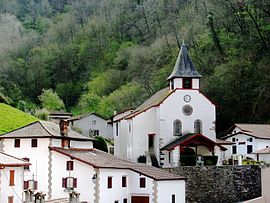 The village and church of Arnéguy | |
show Location of Arnéguy | |
 Arnéguy | |
| Coordinates: 43°07′N 1°17′W / 43.11°N 1.28°WCoordinates: 43°07′N 1°17′W / 43.11°N 1.28°W | |
| Country | France |
| Region | Nouvelle-Aquitaine |
| Department | Pyrénées-Atlantiques |
| Arrondissement | Bayonne |
| Canton | Montagne Basque |
| Intercommunality | CA Pays Basque |
| Government | |
| • Mayor (2020–2026) | Catherine Bègue[1] |
| Area 1 | 21.21 km2 (8.19 sq mi) |
| Population (Jan. 2018)[2] | 237 |
| • Density | 11/km2 (29/sq mi) |
| Time zone | UTC+01:00 (CET) |
| • Summer (DST) | UTC+02:00 (CEST) |
| INSEE/Postal code | 64047 /64220 |
| Elevation | 218–1,410 m (715–4,626 ft) (avg. 389 m or 1,276 ft) |
| 1 French Land Register data, which excludes lakes, ponds, glaciers > 1 km2 (0.386 sq mi or 247 acres) and river estuaries. | |


Arnéguy (French pronunciation: [aʁneɡi]; Basque: Arnegi) is a commune in the Pyrénées-Atlantiques department in southwestern France. The village is an important stopping point on the road between Saint-Jean-Pied-de-Port and Pamplona, Spain, as it lies on the border of France and Spain. It is located in the former province of Lower Navarre. Because of its proximity to Saint-Jean-Pied-de-Port, Arnéguy is a popular tourist destination for those travelling across the Pyrenees, although its economy remains mostly agricultural.
See also[]
References[]
- ^ "Répertoire national des élus: les maires". data.gouv.fr, Plateforme ouverte des données publiques françaises (in French). 2 December 2020.
- ^ "Populations légales 2018". INSEE. 28 December 2020.
External links[]
| Wikimedia Commons has media related to Arnéguy. |
- Official site
- ARNEGI in the Bernardo Estornés Lasa - Auñamendi Encyclopedia (Euskomedia Fundazioa) (in Spanish)
This Pyrénées-Atlantiques geographical article is a stub. You can help Wikipedia by . |
Categories:
- Communes of Pyrénées-Atlantiques
- Lower Navarre
- Pyrénées-Atlantiques geography stubs