Irouléguy
show This article may be expanded with text translated from the corresponding article in French. (December 2008) Click [show] for important translation instructions. |
Irouléguy
Irulegi | |
|---|---|
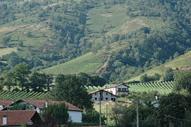 Vineyards | |
show Location of Irouléguy | |
 Irouléguy | |
| Coordinates: 43°10′43″N 1°17′57″W / 43.1786°N 1.2992°WCoordinates: 43°10′43″N 1°17′57″W / 43.1786°N 1.2992°W | |
| Country | France |
| Region | Nouvelle-Aquitaine |
| Department | Pyrénées-Atlantiques |
| Arrondissement | Bayonne |
| Canton | Montagne Basque |
| Intercommunality | CA Pays Basque |
| Government | |
| • Mayor (2020–2026) | Joseph Mocho[1] |
| Area 1 | 9.38 km2 (3.62 sq mi) |
| Population (Jan. 2018)[2] | 359 |
| • Density | 38/km2 (99/sq mi) |
| Time zone | UTC+01:00 (CET) |
| • Summer (DST) | UTC+02:00 (CEST) |
| INSEE/Postal code | 64274 /64220 |
| Elevation | 166–810 m (545–2,657 ft) (avg. 223 m or 732 ft) |
| 1 French Land Register data, which excludes lakes, ponds, glaciers > 1 km2 (0.386 sq mi or 247 acres) and river estuaries. | |


Irouléguy (Basque: Irulegi) is a commune in the Pyrénées-Atlantiques department in south-western France.
It is located in the former province of Lower Navarre.
It is mainly known for the Irouléguy AOC wine which is grown on the vineyards of the area.
See also[]
References[]
- ^ "Répertoire national des élus: les maires". data.gouv.fr, Plateforme ouverte des données publiques françaises (in French). 2 December 2020. Retrieved 7 December 2020.
- ^ "Populations légales 2018". INSEE. 28 December 2020.
External links[]
| Wikimedia Commons has media related to Irouléguy. |
This Pyrénées-Atlantiques geographical article is a stub. You can help Wikipedia by . |
Categories:
- Communes of Pyrénées-Atlantiques
- Lower Navarre
- Pyrénées-Atlantiques geography stubs