Arreau
Arreau | |
|---|---|
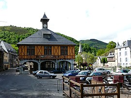 The town hall square | |
 Coat of arms | |
show Location of Arreau | |
 Arreau | |
| Coordinates: 42°54′22″N 0°21′35″E / 42.9061°N 0.3597°ECoordinates: 42°54′22″N 0°21′35″E / 42.9061°N 0.3597°E | |
| Country | France |
| Region | Occitanie |
| Department | Hautes-Pyrénées |
| Arrondissement | Bagnères-de-Bigorre |
| Canton | Neste, Aure et Louron |
| Intercommunality | |
| Government | |
| • Mayor (2020–2026) | Philippe Carrère |
| Area 1 | 11.12 km2 (4.29 sq mi) |
| Population (Jan. 2018)[1] | 784 |
| • Density | 71/km2 (180/sq mi) |
| Time zone | UTC+01:00 (CET) |
| • Summer (DST) | UTC+02:00 (CEST) |
| INSEE/Postal code | 65031 /65240 |
| Elevation | 658–1,756 m (2,159–5,761 ft) (avg. 730 m or 2,400 ft) |
| 1 French Land Register data, which excludes lakes, ponds, glaciers > 1 km2 (0.386 sq mi or 247 acres) and river estuaries. | |


Arreau (French pronunciation: [aʁo]; Occitan: Àrreu) is a commune in the Hautes-Pyrénées department in southwestern France.
It is situated on the former Route nationale 618, the Route of the Pyrénées. Arreau is at the crossroads of the Louron valley and the Aure valley.
Population[]
| Year | Pop. | ±% |
|---|---|---|
| 1962 | 876 | — |
| 1968 | 936 | +6.8% |
| 1975 | 913 | −2.5% |
| 1982 | 816 | −10.6% |
| 1990 | 853 | +4.5% |
| 1999 | 827 | −3.0% |
| 2006 | 838 | +1.3% |
| 2009 | 815 | −2.7% |
| 2015 | 777 | −4.7% |
See also[]
References[]
- ^ "Populations légales 2018". INSEE. 28 December 2020.
| Wikimedia Commons has media related to Arreau. |
| show Authority control |
|---|
This Hautes-Pyrénées geographical article is a stub. You can help Wikipedia by . |
Categories:
- Communes of Hautes-Pyrénées
- Hautes-Pyrénées geography stubs