Arthel
Arthel | |
|---|---|
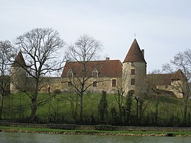 The Château de la Motte, in Arthel | |
show Location of Arthel | |
 Arthel | |
| Coordinates: 47°14′43″N 3°24′35″E / 47.2453°N 3.4097°ECoordinates: 47°14′43″N 3°24′35��E / 47.2453°N 3.4097°E | |
| Country | France |
| Region | Bourgogne-Franche-Comté |
| Department | Nièvre |
| Arrondissement | Cosne-Cours-sur-Loire |
| Canton | La Charité-sur-Loire |
| Intercommunality | CC Les Bertranges |
| Government | |
| • Mayor (2020–2026) | Marc Fauche[1] |
| Area 1 | 7.73 km2 (2.98 sq mi) |
| Population (Jan. 2018)[2] | 96 |
| • Density | 12/km2 (32/sq mi) |
| Time zone | UTC+01:00 (CET) |
| • Summer (DST) | UTC+02:00 (CEST) |
| INSEE/Postal code | 58013 /58700 |
| Elevation | 229–353 m (751–1,158 ft) |
| 1 French Land Register data, which excludes lakes, ponds, glaciers > 1 km2 (0.386 sq mi or 247 acres) and river estuaries. | |


Arthel is a commune in the Nièvre department in central France.
Population[]
| Year | Pop. | ±% |
|---|---|---|
| 1962 | 151 | — |
| 1968 | 161 | +6.6% |
| 1975 | 151 | −6.2% |
| 1982 | 120 | −20.5% |
| 1990 | 97 | −19.2% |
| 1999 | 70 | −27.8% |
| 2006 | 85 | +21.4% |
| 2009 | 91 | +7.1% |
| 2015 | 96 | +5.5% |
See also[]
References[]
- ^ "Répertoire national des élus: les maires". data.gouv.fr, Plateforme ouverte des données publiques françaises (in French). 2 December 2020.
- ^ "Populations légales 2018". INSEE. 28 December 2020.
| Wikimedia Commons has media related to Arthel. |
This Nièvre geographical article is a stub. You can help Wikipedia by . |
Categories:
- Communes of Nièvre
- Nièvre geography stubs