Saint-Bonnot
Saint-Bonnot | |
|---|---|
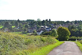 A general view of Saint-Bonnot | |
show Location of Saint-Bonnot | |
 Saint-Bonnot | |
| Coordinates: 47°14′40″N 3°18′54″E / 47.2444°N 3.31500°ECoordinates: 47°14′40″N 3°18′54″E / 47.2444°N 3.31500°E | |
| Country | France |
| Region | Bourgogne-Franche-Comté |
| Department | Nièvre |
| Arrondissement | Cosne-Cours-sur-Loire |
| Canton | La Charité-sur-Loire |
| Government | |
| • Mayor (2020–2026) | Michel Didier-Die[1] |
| Area 1 | 16.14 km2 (6.23 sq mi) |
| Population (Jan. 2018)[2] | 145 |
| • Density | 9.0/km2 (23/sq mi) |
| Time zone | UTC+01:00 (CET) |
| • Summer (DST) | UTC+02:00 (CEST) |
| INSEE/Postal code | 58234 /58700 |
| Elevation | 247–332 m (810–1,089 ft) |
| 1 French Land Register data, which excludes lakes, ponds, glaciers > 1 km2 (0.386 sq mi or 247 acres) and river estuaries. | |


Saint-Bonnot is a commune in the Nièvre department in central France.
See also[]
References[]
- ^ "Répertoire national des élus: les maires". data.gouv.fr, Plateforme ouverte des données publiques françaises (in French). 2 December 2020. Retrieved 7 December 2020.
- ^ "Populations légales 2018". INSEE. 28 December 2020.
| Wikimedia Commons has media related to Saint-Bonnot. |
This Nièvre geographical article is a stub. You can help Wikipedia by . |
Categories:
- Communes of Nièvre
- Nièvre geography stubs