Saint-Éloi, Nièvre
Saint-Éloi | |
|---|---|
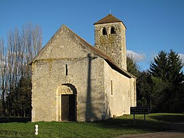 The church of Saint-Symphorien-Chaluzy | |
show Location of Saint-Éloi | |
 Saint-Éloi | |
| Coordinates: 46°58′29″N 3°13′19″E / 46.9747°N 3.2219°ECoordinates: 46°58′29″N 3°13′19″E / 46.9747°N 3.2219°E | |
| Country | France |
| Region | Bourgogne-Franche-Comté |
| Department | Nièvre |
| Arrondissement | Nevers |
| Canton | Nevers-2 |
| Intercommunality | Loire et Allier |
| Government | |
| • Mayor (2020–2026) | Jérôme Malus[1] |
| Area 1 | 16.45 km2 (6.35 sq mi) |
| Population (Jan. 2018)[2] | 2,184 |
| • Density | 130/km2 (340/sq mi) |
| Time zone | UTC+01:00 (CET) |
| • Summer (DST) | UTC+02:00 (CEST) |
| INSEE/Postal code | 58238 /58000 |
| Elevation | 171–244 m (561–801 ft) |
| 1 French Land Register data, which excludes lakes, ponds, glaciers > 1 km2 (0.386 sq mi or 247 acres) and river estuaries. | |


Saint-Éloi is a commune in the Nièvre department in central France.
See also[]
References[]
- ^ "Répertoire national des élus: les maires". data.gouv.fr, Plateforme ouverte des données publiques françaises (in French). 2 December 2020.
- ^ "Populations légales 2018". INSEE. 28 December 2020.
| Wikimedia Commons has media related to Saint-Éloi (Nièvre). |
| show Authority control |
|---|
This Nièvre geographical article is a stub. You can help Wikipedia by . |
Categories:
- Communes of Nièvre
- Nièvre geography stubs