La Charité-sur-Loire
La Charité-sur-Loire | |
|---|---|
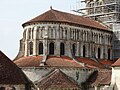
 Sainte-Croix-Notre-Dame in La Charité-sur-Loire | |
 Coat of arms | |
show Location of La Charité-sur-Loire | |
 La Charité-sur-Loire | |
| Coordinates: 47°10′40″N 3°01′11″E / 47.1778°N 3.0197°ECoordinates: 47°10′40″N 3°01′11″E / 47.1778°N 3.0197°E | |
| Country | France |
| Region | Bourgogne-Franche-Comté |
| Department | Nièvre |
| Arrondissement | Cosne-Cours-sur-Loire |
| Canton | La Charité-sur-Loire |
| Intercommunality | Les Bertranges |
| Government | |
| • Mayor (2020–2026) | Henri Valès[1] |
| Area 1 | 15.78 km2 (6.09 sq mi) |
| Population (Jan. 2018)[2] | 4,812 |
| • Density | 300/km2 (790/sq mi) |
| Time zone | UTC+01:00 (CET) |
| • Summer (DST) | UTC+02:00 (CEST) |
| INSEE/Postal code | 58059 /58400 |
| Elevation | 153–215 m (502–705 ft) |
| 1 French Land Register data, which excludes lakes, ponds, glaciers > 1 km2 (0.386 sq mi or 247 acres) and river estuaries. | |


La Charité-sur-Loire is a commune in the Nièvre department and Bourgogne-Franche-Comté region of eastern France.
History[]
The settlement of La Charité grew up around the Cluniac priory of that name, founded on an island site in the River Loire in 1089.
During the Hundred Years War, the town was liberated from the English by French forces led by Joan of Arc on December 25, 1429.
A great fire ravaged the town in 1559.
In the second of the French Wars of Religion (1567–8) La Charité withstood eight months of siege by Catholic forces. It would later be one of the fortified towns given the status of Huguenot safe havens by the Peace of Saint-Germain-en-Laye (August 1570).
By the time of the French Revolution only a dozen monks remained in the priory, which was sold to private individuals and preserved. An improved highway that was to have been driven through the church was deflected by the report of Prosper Mérimée, the first inspector of monuments (and author of Carmen), who classed it as worth saving in 1840.
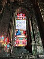
Gallery[]


Population[]
| Year | Pop. | ±% |
|---|---|---|
| 1946 | 5,564 | — |
| 1954 | 5,552 | −0.2% |
| 1962 | 5,742 | +3.4% |
| 1968 | 6,194 | +7.9% |
| 1975 | 6,426 | +3.7% |
| 1982 | 6,416 | −0.2% |
| 1990 | 5,686 | −11.4% |
| 1999 | 5,460 | −4.0% |
| 2005 | 5,405 | −1.0% |
| 2015 | 4,966 | −8.1% |
Sights[]
- The priory church, burial place of Simon I de Senlis, Earl of Huntingdon-Northampton.
- The church of Sainte-Croix-Notre-Dame, listed as a UNESCO World Heritage Site in 1998, as part of the Routes of Santiago de Compostela in France.
See also[]
References[]
- ^ "Répertoire national des élus: les maires". data.gouv.fr, Plateforme ouverte des données publiques françaises (in French). 2 December 2020.
- ^ "Populations légales 2018". INSEE. 28 December 2020.
External links[]
- Official website (in French)
- La Charité on the site Bourgogne Romane (in French)
| Wikimedia Commons has media related to La Charité-sur-Loire. |
| show Authority control |
|---|
This Nièvre geographical article is a stub. You can help Wikipedia by . |
- Communes of Nièvre
- Joan of Arc
- World Heritage Sites in France
- Nièvre geography stubs