Autauga County, Alabama
Autauga County | |
|---|---|
U.S. county | |
 Autauga County Courthouse in Prattville | |
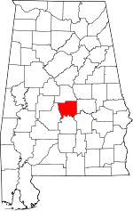 Location within the U.S. state of Alabama | |
 Alabama's location within the U.S. | |
| Coordinates: 32°32′12″N 86°38′54″W / 32.536666666667°N 86.648333333333°W | |
| Country | |
| State | |
| Founded | November 21, 1818 |
| Seat | Prattville |
| Largest city | Prattville |
| Area | |
| • Total | 604 sq mi (1,560 km2) |
| • Land | 594 sq mi (1,540 km2) |
| • Water | 10 sq mi (30 km2) 1.6% |
| Population (2020) | |
| • Total | 58,805 |
| • Density | 97/sq mi (38/km2) |
| Time zone | UTC−6 (Central) |
| • Summer (DST) | UTC−5 (CDT) |
| Congressional district | 2nd |
| Website | www |
| |

Autauga County is a county located in the central portion of the U.S. state of Alabama. As of the 2020 census the population was 58,805.[2] Its county seat is Prattville.[3]
Autauga County is part of the Montgomery metropolitan area.
History[]
Autauga County was established on November 21, 1818, by an act of the Alabama Territorial Legislature (one year before Alabama was admitted as a State). As established, the county included present-day Autauga County, as well as Elmore County and Chilton County. At the time, (aka, ) Indians lived here. Primarily in a village named Atagi (meaning "pure water") situated on the banks of a creek by the same name (called "Pearl Water Creek" by settlers). Autaugas were members of the Alibamu tribe. They sent many warriors to resist Andrew Jackson's invasion in the Creek War. This county was part of the territory ceded by the Creeks in the Treaty of Fort Jackson in 1814.
The first county seat was at , but the court only met there long enough to select a permanent seat at Washington, built on the former site of Atagi in the southeast corner of the county. In 1830, the county seat was moved to a more central location at Kingston and the town of Washington dwindled until it was completely deserted in the late 1830s.
Daniel Pratt arrived in Autauga County in 1833 and founded the new town of Prattville, north of Atagi on the fall line of Autauga Creek. His cotton gin factory quickly became the largest manufacturer of gins in the world and the first major industry in Alabama. It was at his factory, and with his financial backing, that the Prattville Dragoons, a fighting unit for the Confederacy was organized in anticipation of the Civil War. Other units formed in Autauga County included the Autauga Rifles (Autaugaville), The John Steele Guards (western Autauga Co.) and the Varina Rifles (northern Autauga Co.). None of the fighting of the Civil War reached Autauga County, and Pratt was able to secure payment of debts from Northern accounts soon after the war, lessening the disabling effects of the Reconstruction period in the county.
, a former slave belonging to Daniel Pratt, bought a house in the center of Prattville immediately after emancipation and was one of the founding investors in Pratt's . The presence of such a prominent African-American family owning land in an Alabama city as early as the 1860s is exceptional.
In 1866 and 1868, Elmore and Chilton counties respectively were split off from Autauga County, and the county seat was moved to the population center of Prattville, where a new courthouse was completed by local builder George L. Smith in 1870. In 1906, a new and larger courthouse was erected in a modified Richardsonian Romanesque style a block north of the older one. The building was designed by Bruce Architectural Co. of Birmingham and built by Dobson & Bynum of Montgomery.
Geography[]
According to the U.S. Census Bureau, the county has a total area of 604 square miles (1,560 km2), of which 594 square miles (1,540 km2) is land and 10 square miles (26 km2) (1.6%) is water.[4][1] The county is mostly located in the Gulf Coastal Plain region, with a few rolling hills and forests due to its close proximity to the fall line of the eastern United States.[5]
Climate[]
The county has a prevailing humid subtropical climate dominated by its location in the Southern Plains ecological sub-region of the United States.[6]
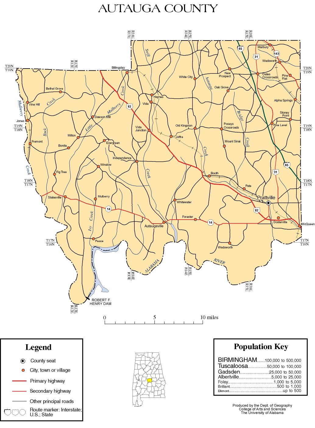
Major highways[]
 Interstate 65
 U.S. Highway 31
 U.S. Highway 82
 State Route 14
 State Route 111
 State Route 143
Adjacent counties[]
- Chilton County - north
- Elmore County - east
- Montgomery County - southeast
- Lowndes County - south
- Dallas County - west
Demographics[]
| Historical population | |||
|---|---|---|---|
| Census | Pop. | %± | |
| 1820 | 3,853 | — | |
| 1830 | 11,874 | 208.2% | |
| 1840 | 14,342 | 20.8% | |
| 1850 | 15,023 | 4.7% | |
| 1860 | 16,739 | 11.4% | |
| 1870 | 11,623 | −30.6% | |
| 1880 | 13,108 | 12.8% | |
| 1890 | 13,330 | 1.7% | |
| 1900 | 17,915 | 34.4% | |
| 1910 | 20,038 | 11.9% | |
| 1920 | 18,908 | −5.6% | |
| 1930 | 19,694 | 4.2% | |
| 1940 | 20,977 | 6.5% | |
| 1950 | 18,186 | −13.3% | |
| 1960 | 18,739 | 3.0% | |
| 1970 | 24,460 | 30.5% | |
| 1980 | 32,259 | 31.9% | |
| 1990 | 34,222 | 6.1% | |
| 2000 | 43,671 | 27.6% | |
| 2010 | 54,571 | 25.0% | |
| 2020 | 58,805 | 7.8% | |
| U.S. Decennial Census[7] 1790–1960[8] 1900–1990[9] 1990–2000[10] 2010–2020[2] | |||
As of the census[11] of 2010, there were 54,571 people, 20,221 households, and 15,064 families residing in the county. The population density was 91 people per square mile (35/km2). There were 22,135 housing units at an average density of 36 per square mile (14/km2). The racial makeup of the county was 78.5% White, 17.7% Black or African American, 0.4% Native American, 0.9% Asian, 0.1% Pacific Islander, and 1.6% from two or more races. 2.4% of the population were Hispanic or Latino of any race.
There were 20,221 households, out of which 34.9% had children under the age of 18 living with them, 56.2% were married couples living together, 13.7% had a female householder with no husband present, and 25.5% were non-families. 22.0% of all households were made up of individuals, and 8.0% had someone living alone who was 65 years of age or older. The average household size was 2.68, and the average family size was 3.13.
In the county, the population was spread out, with 26.8% under the age of 18, 8.5% from 18 to 24, 27% from 25 to 44, 25.7% from 45 to 64, and 12.0% who were 65 years of age or older. The median age was 37 years. For every 100 females, there were 94.9 males.
The median income for a household in the county was $53,682, and the median income for a family was $66,349. Males had a median income of $49,743 versus $32,592 for females. The per capita income for the county was $24,571. About 8.3% of families and 12.1% of the population were below the poverty line, including 17.5% of those under age 18 and 7.0% of those age 65 or over.
In 2000, the largest denominational groups were Evangelical Protestants (with 18,893 adherents) and Mainline Protestants (with 3,657 adherents).[12] The largest religious bodies were The Southern Baptist Convention (with 14,727 members) and The United Methodist Church (with 3,305 members).[12]
Government[]
The sheriff of Autauga County is Joe Sedinger (R). The Revenue Commissioner for the county is Kathy Evans (R), the Probate Judge is Kim Kervin (R), the Circuit Clerk is Deb Hill (R), the Circuit Judge is Ben Fuller (R), the District Attorney is Randall Houston (R) and the District Judge is Joy Booth (R). [13]
The legislature is the county commission which consists of five members all of whom are elected from single member districts. The current Commissioners are:[14]
- District 1: Sid Thompson, Republican
- District 2: John L. Thrailkill, Republican
- District 3: Bill Tatum, Republican
- District 4: Jay Thompson, Republican - Chairman
- District 5: Larry Stoudemire, Democratic
The last Democrat to win the county in a presidential election is Jimmy Carter, who won it by a plurality in 1976.
Education[]
The Autauga County School System is the county's public school system.
East Memorial Christian Academy is located in an unincorporated area of the county, near Prattville.[16]
Places of interest[]
Autauga County is home to several parks, such as Wilderness Park, Cooters Pond Park, Pratt Park, Swift Creek Park, Newton Park, Spinners Park, Heritage Park, and Overlook Memorial Park.
Communities[]
Cities[]
- Millbrook (Partly in Elmore County)
- Prattville (Partly in Elmore County and county seat)
Towns[]
Census-designated places[]
Unincorporated communities[]
Ghost town[]
Notable people[]
- Samuel Smith Harris, (1841-1888), born in Autauga County, Presbyterian clergyman, founder and editor of Living Word magazine, and bishop of the Diocese of Michigan.[17]
- William Henry Lanier, (1855-1929), born in Autauga County, was a prominent educator who served as president of Alcorn A. and M. from 1899 to 1905. He also served as superintendent of Yazoo City and Jackson, Mississippi black schools.[18]
- Wilson Pickett, (1941-2006), born in Prattville, Alabama, American recording artist best known for singing In the Midnight Hour and Mustang Sally.
In popular culture[]
- Autauga County is the main setting of Rita Williams-Garcia's novel Gone Crazy in Alabama.
See also[]
- National Register of Historic Places listings in Autauga County, Alabama
- Properties on the Alabama Register of Landmarks and Heritage in Autauga County, Alabama
References[]
- ^ Jump up to: a b "2019 Gazetteer Files for Counties: Alabama" (text). United States Census Bureau. Retrieved June 9, 2020.
- ^ Jump up to: a b "QuickFacts: Autauga County, Alabama; Population, Census, 2020 & 2010". United States Census Bureau. Retrieved August 19, 2021.
- ^ "Find a County". National Association of Counties. Archived from the original on May 31, 2011. Retrieved June 7, 2011.
- ^ "2010 Census Gazetteer Files". United States Census Bureau. August 22, 2012. Retrieved August 22, 2015.
- ^ http://www.encyclopediaofalabama.org/article/h-1073
- ^ United States Department of Agriculture (USDA) Forest Service Ecoregions and Subregions of the United States, compiled and edited by W. Henry McNab and Robert G. Bailey, U. S. Government Printing Office, 1994.
- ^ "U.S. Decennial Census". United States Census Bureau. Retrieved August 22, 2015.
- ^ "Historical Census Browser". University of Virginia Library. Retrieved August 22, 2015.
- ^ Forstall, Richard L., ed. (March 24, 1995). "Population of Counties by Decennial Census: 1900 to 1990". United States Census Bureau. Retrieved August 22, 2015.
- ^ "Census 2000 PHC-T-4. Ranking Tables for Counties: 1990 and 2000" (PDF). United States Census Bureau. April 2, 2001. Retrieved August 22, 2015.
- ^ "U.S. Census website". United States Census Bureau. Retrieved May 14, 2011.
- ^ Jump up to: a b "County Membership Reports". thearda.com. Archived from the original on July 12, 2011. Retrieved August 22, 2011.
- ^ "Autauga County: Elected Officials". www.autaugaco.org. Archived from the original on February 10, 2020. Retrieved August 29, 2020.
- ^ "Autauga County: Commissioners". www.autaugaco.org. Archived from the original on February 10, 2020. Retrieved August 29, 2020.
- ^ "Dave Leip's Atlas of U.S. Presidential Elections". Retrieved November 15, 2016.
- ^ "Home Archived August 21, 2013, at the Wayback Machine." East Memorial Christian Academy. Retrieved on August 3, 2013. "1320 Old Ridge Road Prattville, Alabama 36066"
- ^ Who Was Who in America, Historical Volume, 1607-1896. Chicago: Marquis Who's Who. 1963.
- ^ "School History". Lanier High School. Jackson (MS) Public Schools. Retrieved October 20, 2017.
Lanier was first organized as a junior-senior high school in 1925 providing instruction for pupils from the seventh through the twelfth grades.
External links[]
| Wikimedia Commons has media related to Autauga County, Alabama. |
- Autauga County's Official Website
- Alabama Historical Association Markers in Autauga County[permanent dead link]
- Autauga County Genealogical Information at Rootsweb.com
- Autauga County map of roads/towns (map © 2007 Univ. of Alabama).
- River Region Tourism Site
| show Places adjacent to Autauga County, Alabama |
|---|
| show Municipalities and communities of Autauga County, Alabama, United States |
|---|


Coordinates: 32°32′12″N 86°38′54″W / 32.53667°N 86.64833°W
| show Authority control |
|---|
- Alabama counties
- Autauga County, Alabama
- Montgomery metropolitan area
- 1818 establishments in Alabama Territory
- Populated places established in 1818