Barbirey-sur-Ouche
Barbirey-sur-Ouche | |
|---|---|
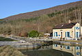
 Lavoir (Public laundry) | |
 Coat of arms | |
show Location of Barbirey-sur-Ouche | |
 Barbirey-sur-Ouche | |
| Coordinates: 47°15′13″N 4°45′20″E / 47.2536°N 4.7556°ECoordinates: 47°15′13″N 4°45′20″E / 47.2536°N 4.7556°E | |
| Country | France |
| Region | Bourgogne-Franche-Comté |
| Department | Côte-d'Or |
| Arrondissement | Dijon |
| Canton | Talant |
| Government | |
| • Mayor (2020–2026) | Valérie Paupert[1] |
| Area 1 | 10.76 km2 (4.15 sq mi) |
| Population (Jan. 2018)[2] | 213 |
| • Density | 20/km2 (51/sq mi) |
| Time zone | UTC+01:00 (CET) |
| • Summer (DST) | UTC+02:00 (CEST) |
| INSEE/Postal code | 21045 /21410 |
| Elevation | 298–589 m (978–1,932 ft) (avg. 300 m or 980 ft) |
| 1 French Land Register data, which excludes lakes, ponds, glaciers > 1 km2 (0.386 sq mi or 247 acres) and river estuaries. | |


Barbirey-sur-Ouche is a commune in the Côte-d'Or department in the Bourgogne-Franche-Comté region of eastern France.[3]
The inhabitants of the commune are known as Barbirotins or Barbirotines.[4]
Geography[]
Barbirey-sur-Ouche is located some 25 km south-west of Dijon and 11 km east of Créancey. Access to the commune is by the D33 road from Gissey-sur-Ouche in the north-east which passes through the village and continues south to Saint-Victor-sur-Ouche. The D114 goes west from the village then north-west to Grenant-lès-Sombernon. The commune is heavily forested on the hillsides to the north and south with farmland in the valley.[5][6]
The Ouche river passes through the commune just east of the village flowing from south to north to eventually join the Saône just east of Saint-Jean-de-Losne. The Ruisseau de la Gironde flows from the west down the valley to join the Ouche near the village. The Canal de Bourgogne (Burgundy Canal) also passes through the commune parallel to the Ouche on the eastern side. There are two locks in the commune - the Écluse de Dainevy to the south and another lock further north.[5]
History[]
On 17 March 1794 Jean Vivant Micault de Corbeton (10 May 1725 - 17 March 1794), Chairman of the Parliament of Burgundy in Dijon before the French revolution, Lord of Agey, Meilly-sur-Rouvres, Rouvres-sous-Meilly, Saligny, Liernolles, Maconge, Barbirey-sur-Ouche, Santenay, Pommard, and other places, last Marquis of Joncy, and husband of Marie Françoise Trudaine, was beheaded in the Place du Morimont (now the Place Emile Zola) in Dijon.
Barbirey-sur-Ouche appears as Barbirey fur Ouche on the 1750 Cassini Map[7] and the same on the 1790 version.[8]
Heraldry[]
 |
Blazon: Azure, a bend vivré of Or debruised by a label of 5 points of Gules at honour point.
|
Administration[]
This list is incomplete; you can help by . (April 2021) |
| From | To | Name |
|---|---|---|
| 1944 | 1981 | Maurice Coquet |
| 1981 | 1995 | Jean-Paul Coquet |
| 1995 | 2008 | Michel Guichard |
| 2008 | 2014 | Jean-Claude Hayme |
| 2014 | 2020 | Robert Bott |
| 2020 | 2026 | Valérie Paupert |
Demography[]
In 2017 the commune had 216 inhabitants.
|
| ||||||||||||||||||||||||||||||||||||||||||||||||||||||||||||||||||||||||||||||||||||||||||||||||||||||||||||||||||
| Source: EHESS[10] and INSEE[11] | |||||||||||||||||||||||||||||||||||||||||||||||||||||||||||||||||||||||||||||||||||||||||||||||||||||||||||||||||||
Culture and heritage[]

Civil heritage[]

The commune has a number of buildings and sites that are registered as historical monuments:
- A Vineyard (19th century)
 [12]
[12] - Houses and Farms (18th-19th century)[13]
- A Chateau (16th century)[14]
- The Chateau Grounds (17th century)[15]
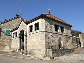
- A Lavoir (Public laundry) at Jaugey (1836).[16] The Lavoir contains two items that are registered as historical objects:
- A Lavoir (Public laundry) (1863)[19]
- A School (19th century)[20]
- Other sites of interest
- A Tumulus and cave at Roche-Chèvre
Barbirey-sur-Ouche Picture Gallery[]


The Tumulus
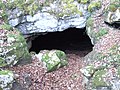
The cave at Roche Chèvre

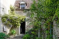
Entry to the Chateau

The Chateau

The Dovecote at the Chateau
The entry to the bread oven
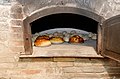
The bread oven at the Chateau

Plaque commemorating Charles de Foucauld
A lock on the Canal de Bourgogne in Barbirey-sur-Ouche


Religious heritage[]

The commune has several religious buildings and structures that are registered as historical monuments:
- The Parish Church of Saint Martin (12th century).[21] The Church contains many items that are registered as historical objects:
See also[]
References[]
- ^ "Répertoire national des élus: les maires". data.gouv.fr, Plateforme ouverte des données publiques françaises (in French). 2 December 2020.
- ^ "Populations légales 2018". INSEE. 28 December 2020.
- ^ Barbirey-sur-Ouche on Lion1906
- ^ Inhabitants of Côte-d'Or (in French)
- ^ Jump up to: a b c Barbirey-sur-Ouche on Google Maps
- ^ Barbirey-sur-Ouche on the Géoportail from National Geographic Institute (IGN) website (in French)
- ^ Barbirey fur Ouche on the 1750 Cassini Map
- ^ Barbirey fur Ouche on the 1790 Cassini Map
- ^ List of Mayors of France (in French)
- ^ Des villages de Cassini aux communes d'aujourd'hui: Commune data sheet Barbirey-sur-Ouche, EHESS. (in French)
- ^ Population en historique depuis 1968, INSEE
- ^ Ministry of Culture, Mérimée IA00059694 Vineyard (in French)
- ^ Ministry of Culture, Mérimée IA00059856 House 1 IA00059857 Farmhouse 2 IA00059855 House 2 IA00059854 House 3 IA00059853 House at Jaugey IA00059817 Houses and Farms(in French)
- ^ Ministry of Culture, Mérimée IA00059695 Chateau (in French)
- ^ Ministry of Culture, Mérimée PA21000032 Chateau Grounds (in French)
- ^ Ministry of Culture, Mérimée IA00125210
 IA00059781 Lavoir at Jaugey (in French)
- ^ Ministry of Culture, Palissy PM21000165 Bronze Bell (in French)
- ^ Ministry of Culture, Palissy IM21004363 Furniture in the Lavoir (in French)
- ^ Ministry of Culture, Mérimée IA00059780 Lavoir (in French)
- ^ Ministry of Culture, Mérimée IA00059693 School (in French)
- ^ Ministry of Culture, Mérimée IA00059696 Parish Church of Saint Martin (in French)
- ^ Ministry of Culture, Palissy PM21000164 Bronze bell (in French)
- ^ Ministry of Culture, Palissy PM21000163 Virgin and child IM21004361 Saint Catherine of Alexandria IM21004360 Saint reading IM21004358 Virgin and child (No. 1) IM21004359 Virgin and child (No. 2) IM21004356 2 Statues: Saints Martin and Sebastian (in French)
- ^ Ministry of Culture, Palissy IM21004362 Furniture in the Church (in French)
- ^ Ministry of Culture, Palissy IM21004357 Half-relief: Adoration of the Shepherds (in French)
- ^ Ministry of Culture, Palissy IM21004355 Retable (in French)
| Wikimedia Commons has media related to Barbirey-sur-Ouche. |
| show Authority control |
|---|
- Communes of Côte-d'Or