Borchaly Uyezd
Borchaly Uyezd
Борчалинский уезд | |
|---|---|
 Coat of arms | |
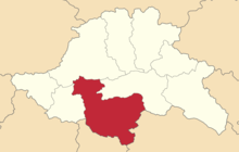 Location in the Tiflis Governorate | |
| Country | Russian Empire |
| Governorate | Tiflis |
| Viceroyalty | Caucasus |
| Established | 1880 |
| Abolished | 1929 |
| Seat | Shulavery (Shaumiani) |
| Uchastoks | Borchaly, Ekaterinenfeld, Lori, and Trialet |
| Area | |
| • Total | 6,758 km2 (2,609 sq mi) |
| Population (1916) | |
| • Total | 169,351 |
| • Density | 25/km2 (65/sq mi) |
The Borchaly Uyezd (Russian: Борчалинский уезд; Georgian: ბორჩალოს მაზრა; Armenian: Բորչալուի գավառ; Azerbaijani: Borçalı qəzası) was an uezd (county) of the Tiflis Governorate of the Caucasus Viceroyalty of the Russian Empire, and then of Democratic Republic of Georgia and of Democratic Republic of Armenia, with its administrative center in Shulavery (Shaumiani).[1][2] The area of the uyezd roughly corresponded to the contemporary Lori Province of Armenia and the Kvemo Kartli region of Georgia.
History[]

The Debed river, formerly known as Borchaly, gave the name of the Borchaly Uyezd, however, the region was also known as Borchalo (ბორჩალო) in Georgian, Borchalu (Բորչալու) in Armenian, and Borchala (Борчала) in Russian. The Turkic locals were resettled to the Debed river valley through the policy of Shah Abbas I (c.1571-1629) after his successful campaigns against the Kingdoms of Kartli and Kakheti that led to the formation of several Qizilbash khanates. The region was later reincorporated into the Kingdom of Kartli in the 18th century, subsequently being incorporated into the Kartli-Kakheti monarchy in 1762. In 1801, through Russia's annexation of eastern Georgia, Borchaly became part of Russia's Georgia Governorate, which was eventually transformed to become the Tiflis Governorate.
Following the Russian Revolution and the short-lived independence of the Democratic Republic of Georgia and the First Republic of Armenia, the Borchaly Uyezd became the site of a 2-week-war between the two countries in December 1918, until its British-brokered ceasefire starting 1 January 1919. Most of the Lori Uchastok, excepting the very southern part which was annexed to Armenia, was turned into a neutral zone. The neutral zone over Lori which was concentrated around the copper mining town of Alaverdi was originally patrolled by British troops of the 27th Division, until their withdrawal and replacement by Armenian-Georgian forces, consisting of the Georgian commissar Alexandre Lordkipanidze and Armenian commissar Lieutenant Colonel G. Vardapetian (and subsequently Valad Valadian). The mixed-administration was not without problems, as the Georgians soon charged that Armenian officials were behaving as if the district was an integral part of Armenia, and the Armenians claimed that Lordkipanidze was trying to get Muslim and Russian Molokan villages—but without success—to petition for incorporation into Georgia.
In late 1920, the neutral zone of Lori and the southernmost section of the Lori Uchastok which had been annexed to Armenia was with their permission reincorporated into Georgia for the safety of its inhabitants as a result of the Turkish-Armenian War. Georgia continued to administer the reunited Borchaly Uyezd until its Sovietization and the district's partition between the newly-formed Armenian and Georgian Soviet republics.
Administrative divisions[]
The uchastoks (sub-counties) of the Borchaly Uyezd were:[3]
- Borchaly (Борчалинский участок)
- Ekaterinenfeld (Екатериненфельдский участок)
- Lori (Лорийский участок)
- Trialet (Триалетский участок)
Demographics[]
Russian Imperial Census of 1897[]
According to census held in 1897, the population of uyezd was 128,587 and its ethnic makeup was the following:[4][5]
- Armenians - 47,423 (36.9%)
- Tatars (later known as Azerbaijanis) - 37,742 (29.4%)
- Greeks - 21,393 (16.6%)
- Russians - 8,089 (6.3%)
- Georgians - 7,840 (6.1%)
- Germans - 2,496 (1.9%)
Caucasian Calendar of 1917[]
The 1917 Caucasian Calendar which produced statistics of 1916 indicates 169,351 residents in the Borchaly Uyezd, including 89,040 men and 80,311 women, 160,447 of whom were the permanent population, and 8,904 were temporary residents:[6]
| Nationality | Borchaly | |
|---|---|---|
| Armenians | 63,702 | 37.6% |
| Tatars (later known as Azerbaijanis) | 51,230 | 30.3% |
| Greeks | 30,762 | 18.2% |
| Georgians | 10,419 | 6.2% |
| Russians | 8,772 | 5.2% |
| Germans | 3,601 | 2.1% |
| North Caucasians | 366 | 0.2% |
| Gypsies | 255 | 0.2% |
| Jews | 244 | 0.1% |
| TOTAL | 169,351 | 100.0% |
See also[]
References[]
- ^ Brockhaus and Efron Encyclopaedia: Tiflis Governorate (in Russian)
- ^ Tsutsiev, Arthur (2014), Atlas of the Ethno-Political History of the Caucasus, New Haven and London, p. 164, ISBN 978-0-300-15308-8, OCLC 884858065, retrieved 2021-12-25
- ^ Кавказский календарь .... на 1913 год (in Russian). Tiflis: Office of the Viceroy of the Caucasus. 1913. pp. 271–317.
- ^ "Archived copy". Archived from the original on 2012-08-29. Retrieved 2011-09-11.CS1 maint: archived copy as title (link) CS1 maint: bot: original URL status unknown (link)
- ^ Борчалинский уезд (in Russian)
- ^ Кавказский календарь .... на 1917 год (in Russian). Tiflis: Office of the Viceroy of the Caucasus. 1917. pp. 363–366.
This Georgia location article is a stub. You can help Wikipedia by . |
This Armenia location article is a stub. You can help Wikipedia by . |
Coordinates: 41°20′38″N 44°45′30″E / 41.34389°N 44.75833°E

- Caucasus Viceroyalty (1801–1917)
- Tiflis Governorate
- Modern history of Georgia (country)
- 1880 establishments in the Russian Empire
- States and territories established in 1880
- States and territories disestablished in 1918
- Georgia (country) geography stubs
- Armenia geography stubs