Boudreville
From Wikipedia, the free encyclopedia
Commune in Bourgogne-Franche-Comté, France
Boudreville | |
|---|---|
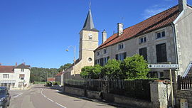 The church and surroundings in Boudreville | |
 Coat of arms | |
 Boudreville  Boudreville | |
Coordinates:  47°56′08″N 4°49′43″E / 47.9356°N 4.8286°E / 47.9356; 4.8286Coordinates: 47°56′08″N 4°49′43″E / 47.9356°N 4.8286°E / 47.9356; 4.8286 47°56′08″N 4°49′43″E / 47.9356°N 4.8286°E / 47.9356; 4.8286Coordinates: 47°56′08″N 4°49′43″E / 47.9356°N 4.8286°E / 47.9356; 4.8286 | |
| Country | France |
| Region | Bourgogne-Franche-Comté |
| Department | Côte-d'Or |
| Arrondissement | Montbard |
| Canton | Châtillon-sur-Seine |
| Intercommunality | Pays Châtillonnais |
| Government | |
| • Mayor (2020–2026) | Marcel Klinkert |
| Area 1 | 7.94 km2 (3.07 sq mi) |
| Population (Jan. 2018)[1] | 61 |
| • Density | 7.7/km2 (20/sq mi) |
| Time zone | UTC+01:00 (CET) |
| • Summer (DST) | UTC+02:00 (CEST) |
| INSEE/Postal code | 21090 /21520 |
| Elevation | 238–312 m (781–1,024 ft) (avg. 240 m or 790 ft) |
| 1 French Land Register data, which excludes lakes, ponds, glaciers > 1 km2 (0.386 sq mi or 247 acres) and river estuaries. | |

show This article may be expanded with text translated from the corresponding article in French. (January 2009) Click [show] for important translation instructions.
|
Boudreville is a commune in the Côte-d'Or department in eastern France, in which the forest nearby (Le Bois de Fée) has a large population of boar, deer, and other animals. The forest is owned by George Garnier.
Population[]
| Year | Pop. | ±% |
|---|---|---|
| 1962 | 48 | — |
| 1968 | 83 | +72.9% |
| 1975 | 80 | −3.6% |
| 1982 | 86 | +7.5% |
| 1990 | 72 | −16.3% |
| 1999 | 76 | +5.6% |
| 2008 | 62 | −18.4% |
See also[]
References[]
- ^ "Populations légales 2018". INSEE. 28 December 2020.
| Wikimedia Commons has media related to Boudreville. |
| show | |
|---|---|
|
| show Authority control | |
|---|---|
| General |
|
| National libraries | |
Retrieved from ""
Categories:
- Communes of Côte-d'Or
- Côte-d'Or geography stubs
Hidden categories:
- Articles with short description
- Short description is different from Wikidata
- Infobox mapframe without OSM relation ID on Wikidata
- Coordinates on Wikidata
- Pages using infobox settlement with image map1 but not image map
- Articles to be expanded from January 2009
- All articles to be expanded
- Geography articles needing translation from French Wikipedia
- Commons category link is on Wikidata
- Articles with VIAF identifiers
- Articles with BNF identifiers
- Articles with WorldCat-VIAF identifiers
- Côte-d'Or communes articles needing translation from French Wikipedia
- All stub articles
- Pages using the Kartographer extension