Buis-les-Baronnies
Buis-les-Baronnies | |
|---|---|
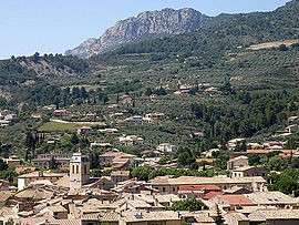 A general view of Buis-les-Baronnies | |
 Coat of arms | |
show Location of Buis-les-Baronnies | |
 Buis-les-Baronnies | |
| Coordinates: 44°16′35″N 5°16′31″E / 44.2764°N 5.2753°ECoordinates: 44°16′35″N 5°16′31″E / 44.2764°N 5.2753°E | |
| Country | France |
| Region | Auvergne-Rhône-Alpes |
| Department | Drôme |
| Arrondissement | Nyons |
| Canton | Nyons et Baronnies |
| Government | |
| • Mayor (2020–2026) | Sébastien Bernard[1] |
| Area 1 | 33.74 km2 (13.03 sq mi) |
| Population (Jan. 2018)[2] | 2,305 |
| • Density | 68/km2 (180/sq mi) |
| Time zone | UTC+01:00 (CET) |
| • Summer (DST) | UTC+02:00 (CEST) |
| INSEE/Postal code | 26063 /26170 |
| Elevation | 319–1,080 m (1,047–3,543 ft) (avg. 370 m or 1,210 ft) |
| 1 French Land Register data, which excludes lakes, ponds, glaciers > 1 km2 (0.386 sq mi or 247 acres) and river estuaries. | |


Buis-les-Baronnies (French pronunciation: [bɥi le baʁɔni]; Vivaro-Alpine: Lo Bois dei Baroniás) is a commune in the Drôme department in southeastern France.
Geography[]
Buis-les-Baronnies is located on the right bank of the river Ouvèze (Buis-les-Baronnies as a town has limits on the other bank).
Population[]
| Year | Pop. | ±% |
|---|---|---|
| 1911 | 1,806 | — |
| 1962 | 1,496 | −17.2% |
| 1968 | 1,602 | +7.1% |
| 1975 | 1,729 | +7.9% |
| 1982 | 1,885 | +9.0% |
| 1990 | 2,030 | +7.7% |
| 1999 | 2,226 | +9.7% |
| 2008 | 2,312 | +3.9% |
See also[]
References[]
- ^ "Répertoire national des élus: les maires". data.gouv.fr, Plateforme ouverte des données publiques françaises (in French). 2 December 2020.
- ^ "Populations légales 2018". INSEE. 28 December 2020.
| Wikimedia Commons has media related to Buis-les-Baronnies. |
| show Authority control |
|---|
This Drôme geographical article is a stub. You can help Wikipedia by . |
Categories:
- Communes of Drôme
- Drôme geography stubs