Château-Gontier-sur-Mayenne
Château-Gontier-sur-Mayenne | |
|---|---|
Subprefecture and commune | |
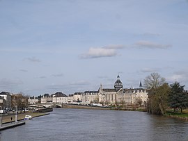 Château-Gontier seen from the Europe Bridge | |
Location of Château-Gontier-sur-Mayenne  | |
 Château-Gontier-sur-Mayenne | |
| Coordinates: 47°49′43″N 0°42′10″W / 47.8286°N 0.7028°WCoordinates: 47°49′43″N 0°42′10″W / 47.8286°N 0.7028°W | |
| Country | France |
| Region | Pays de la Loire |
| Department | Mayenne |
| Arrondissement | Château-Gontier |
| Canton | Château-Gontier-sur-Mayenne-1 and 2 |
| Government | |
| • Mayor (2020-2026) | Philippe Henry |
| Area 1 | 68.49 km2 (26.44 sq mi) |
| Population (Jan. 2018)[1] | 16,913 |
| • Density | 250/km2 (640/sq mi) |
| Time zone | UTC+01:00 (CET) |
| • Summer (DST) | UTC+02:00 (CEST) |
| INSEE/Postal code | 53062 /53200 |
| Elevation | 22–99 m (72–325 ft) |
| 1 French Land Register data, which excludes lakes, ponds, glaciers > 1 km2 (0.386 sq mi or 247 acres) and river estuaries. | |


Château-Gontier-sur-Mayenne (French pronunciation: [ʃɑto.ɡɔ̃tje.syʁ.majɛn]) is a commune in the Mayenne department in north-western France. It was established on 1 January 2019 by merger of the former communes of Château-Gontier (the seat), Azé and Saint-Fort.[2]
See also[]
- Communes of the Mayenne department
References[]
- ^ "Populations légales 2018". The National Institute of Statistics and Economic Studies. 28 December 2020.
- ^ Arrêté préfectoral 14 November 2018 (in French)
| Wikimedia Commons has media related to Château-Gontier-sur-Mayenne. |
This Mayenne geographical article is a stub. You can help Wikipedia by . |
Categories:
- Communes of Mayenne
- Subprefectures in France
- Mayenne geography stubs