Daon
Daon | |
|---|---|
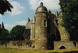 The , in Daon | |
 Coat of arms | |
show Location of Daon | |
 Daon | |
| Coordinates: 47°45′03″N 0°38′15″W / 47.7508°N 0.6375°WCoordinates: 47°45′03″N 0°38′15″W / 47.7508°N 0.6375°W | |
| Country | France |
| Region | Pays de la Loire |
| Department | Mayenne |
| Arrondissement | Château-Gontier |
| Canton | Château-Gontier-sur-Mayenne-1 |
| Area 1 | 17.93 km2 (6.92 sq mi) |
| Population (Jan. 2018)[1] | 503 |
| • Density | 28/km2 (73/sq mi) |
| Time zone | UTC+01:00 (CET) |
| • Summer (DST) | UTC+02:00 (CEST) |
| INSEE/Postal code | 53089 /53200 |
| Elevation | 19–81 m (62–266 ft) (avg. 73 m or 240 ft) |
| 1 French Land Register data, which excludes lakes, ponds, glaciers > 1 km2 (0.386 sq mi or 247 acres) and river estuaries. | |


Daon is a commune in the Mayenne department in north-western France.
See also[]
- Communes of the Mayenne department
References[]
- ^ "Populations légales 2018". INSEE. 28 December 2020.
| Wikimedia Commons has media related to Daon. |
| show Communes of the Mayenne department |
|---|
This Mayenne geographical article is a stub. You can help Wikipedia by . |
Categories:
- Communes of Mayenne
- Mayenne geography stubs