Chaniers
show This article may be expanded with text translated from the corresponding article in French. (December 2008) Click [show] for important translation instructions. |
Chaniers | |
|---|---|
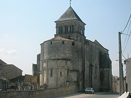 The church in Chaniers | |
 Coat of arms | |
show Location of Chaniers | |
 Chaniers | |
| Coordinates: 45°43′08″N 0°33′21″W / 45.7189°N 0.5558°WCoordinates: 45°43′08″N 0°33′21″W / 45.7189°N 0.5558°W | |
| Country | France |
| Region | Nouvelle-Aquitaine |
| Department | Charente-Maritime |
| Arrondissement | Saintes |
| Canton | Chaniers |
| Government | |
| • Mayor (2020–2026) | Éric Pannaud (PR) |
| Area 1 | 26.53 km2 (10.24 sq mi) |
| Population (Jan. 2018)[1] | 3,588 |
| • Density | 140/km2 (350/sq mi) |
| Time zone | UTC+01:00 (CET) |
| • Summer (DST) | UTC+02:00 (CEST) |
| INSEE/Postal code | 17086 /17610 |
| Elevation | 2–74 m (6.6–242.8 ft) |
| 1 French Land Register data, which excludes lakes, ponds, glaciers > 1 km2 (0.386 sq mi or 247 acres) and river estuaries. | |


Chaniers (French pronunciation: [ʃanje]) is a commune in the Charente-Maritime department in southwestern France.
Population[]
|
|
See also[]
References[]
- ^ "Populations légales 2018". INSEE. 28 December 2020.
| Wikimedia Commons has media related to Chaniers. |
This Charente-Maritime geographical article is a stub. You can help Wikipedia by . |
Categories:
- Communes of Charente-Maritime
- Charente-Maritime geography stubs