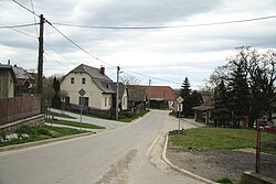
Chlumek
Chlumek | |
|---|---|
Municipality | |
 | |
 Flag 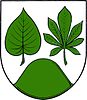 Coat of arms | |
 Chlumek | |
| Coordinates: 49°22′29″N 15°51′19″E / 49.37472°N 15.85528°ECoordinates: 49°22′29″N 15°51′19″E / 49.37472°N 15.85528°E | |
| Country | |
| Region | Vysočina |
| District | Žďár nad Sázavou |
| Area | |
| • Total | 6.56 km2 (2.53 sq mi) |
| Elevation | 578 m (1,896 ft) |
| Population (1.1.2013) | |
| • Total | 183 |
| • Density | 28/km2 (72/sq mi) |
| Postal code | 594 42 |
| Website | http://www.chlumek.cz |

Chlumek is a village and municipality (obec) in Žďár nad Sázavou District in the Vysočina Region of the Czech Republic.
The municipality covers an area of 6.56 square kilometres (2.53 sq mi), and has a population of 182 (as at 28 August 2006).
Chlumek lies approximately 22 kilometres (14 mi) south of Žďár nad Sázavou, 20 km (12 mi) east of Jihlava, and 130 km (81 mi) south-east of Prague.
References[]
| Wikimedia Commons has media related to Chlumek. |
| Authority control: National libraries |
|---|
This Vysočina Region location article is a stub. You can help Wikipedia by . |
Categories:
- Villages in Žďár nad Sázavou District
- Vysočina Region geography stubs