Dalečín
Dalečín | |
|---|---|
Municipality | |
 | |
 Flag 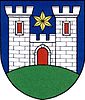 Coat of arms | |
 Dalečín | |
| Coordinates: 49°35′30″N 16°14′39″E / 49.59167°N 16.24417°ECoordinates: 49°35′30″N 16°14′39″E / 49.59167°N 16.24417°E | |
| Country | |
| Region | Vysočina |
| District | Žďár nad Sázavou |
| Area | |
| • Total | 16.3 km2 (6.3 sq mi) |
| Elevation | 472 m (1,549 ft) |
| Population (1.1.2014) | |
| • Total | 642 |
| • Density | 39/km2 (100/sq mi) |
| Postal code | 592 41 to 592 65 |
| Website | http://www.obecdalecin.cz/ |

Dalečín is a village and municipality (obec) in Žďár nad Sázavou District in the Vysočina Region of the Czech Republic. Dalečín lies approximately 23 kilometres (14 mi) east of Žďár nad Sázavou, 53 km (33 mi) north-east of Jihlava, and 142 km (88 mi) south-east of Prague. The municipality consist of the Dalečín, Hluboké and Veselí. had been part of the municipality since 1955 until its flooding by .
The name is most probably related to first name Daleca, which could be a form of names Dalebor or Dalemil. Throughout history the name of the village had different forms – for example Daleczin, Daleczyn, Daletčín, Dalecžin, Dalletchin or Daletschin. The municipality covers an area of 16.3 square kilometres (6.3 sq mi), and has a population of 642 (as at 2014).
| Year | 1869 | 1880 | 1890 | 1900 | 1910 | 1921 | 1930 | 1950 | 1961 | 1970 | 1980 | 1991 | 2001 |
|---|---|---|---|---|---|---|---|---|---|---|---|---|---|
| Population | 1065 | 1099 | 1102 | 1074 | 1013 | 984 | 937 | 772 | 827 | 813 | 799 | 775 | 723 |
History[]
The first (and often questioned) reference to Dalečín dates back to 1086 in a document from at Opatovice nad Labem, where it is referred to as Daletice. The first reliable reference dates back to 1349 when Dalečín was passed to Znat from Tasov from his wife Klára. In that period Dalečín functioned as a center of a separate dominion, which was in 1358 gained by Jimram from Pernštejn. Further known historical events are based on the Moravian land tables (Czech: Moravské zemské desky). In 1588 Jan from Pernštejn sold the village to Pavel Katharyn from Kathar. Two years later it was gained by his wife Krizelda Čejkovna from Olbramovice. In 1603 Dalečín was sold by Petr a Jan Katharyns together with surrounding villages to Vilém Dubský from Třebomyslice. The property of Vilém Dubský from Třebomyslice was confiscated after the Battle of White Mountain (Czech: Bitva na Bílé hoře) and Štěpán Schmidt from Freihofen became the new owner. Between 1624 and 1633 Dalečín dominion became part of Kunštát dominion thanks to countess Šliková from Salm. A hop garden was present in Dalečín in the middle of 17th century. The village stayed part of Kunštát dominion until the abolition of manorialism. The last owner was free lord Honrichs.
Places of interest[]
The ruins of Dalečín castle[]
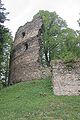
Dalečín castle is situated in a valley on the left side of Svratka river which protects it from three sides. The castle makes part of a series of castles along Svratka river which were constructed in the 13th or the 14th century. Dalečín castle was supposedly built around 1340. This estimation is based on the archictonical features of the castle (Luxembourgian gothics). The first reference about the castle dates back to 1358 when the castle was passed to Pernštejn family. The following period appears to have been relatively calm as there are few reference to the castle found in the literature. However, since the beginning of the 16th century the castle experienced turbulent times because it was probably a seat of robber knights. In 1519 the castle was devastated by an army which was led by Artleb Vranovský from Boskovice. From then on the castle was stated as deserted. The original form of the castle is not known. It is assumed that it had a cylinder shape with an outer diameter of 30 meters with a prismatic tower on the southwestern side. The castle had three floors. To the current times only parts of the castle were preserved (parts of perimeter walls with windows and battlement, small part of the tower and parts of walls).
The chateau[]
The chateau was built around 1590 by Pavel Katharyn from Kathar close to deserted Dalečín castle. Masonry of the castle was used for the construction of the chateau. The Renaissance chateau had a number of owners and at the end of 19th century it was rebuilt in the style of Tirol cottage. The last owner from nobility was young countess Františka Coudenhove-Honrichs. In the 1919 land reform the chateau was confiscated by the state. However, the chateau and the castle were returned to Františka Coudenhove-Honrichs in 1924. She donated the chateau to Congregation of the Consolatory Sisters of the Jesus Divine Heart (Czech: Kongregace těšitelek Božského srdce Ježíšova). During the World War II the chateau functioned for training of . After the end of the war the chateau was returned to the Rajhrad Convent. However, the chateau was transferred into the use of the state in the early 1950s. The exteriors were renovated in 1998 and 1999. The chateau nowadays hosts the municipality office, doctor’s office and municipality housing.
Other places of interest are St. James the Great Church or Villa Jarošek.
Gallery[]
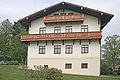
Former chateau in Dalečín - currently used as the municipality office

Dalečín castle - the entrance

Dalečín castle
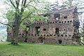
Dalečín castle

Dalečín castle - remainder of the bearing wall
Dalečín castle

A view at a remaining part of Dalečín castle in 2006


References[]
- ^ Balcar, Vladimír; Havel, Radek; Křídlo, Josef; Pavlíková, Marie; Růžková, Jiřina; Šanda, Robert; Škrabal, Josef (2006): Historický lexikon obcí České republiky 1869–2005. Český statistický úřad, Praha, ISBN 80-250-1311-1.
| Wikimedia Commons has media related to Dalečín. |
| show Authority control |
|---|
- Villages in Žďár nad Sázavou District