Dříteň
Dříteň | |
|---|---|
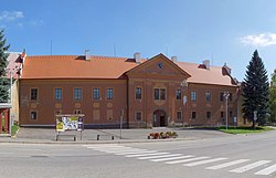 Dříteň Castle before reconstruction | |
 Flag  Coat of arms | |
 Dříteň Location in the Czech Republic | |
| Coordinates: 49°8′34″N 14°20′46″E / 49.14278°N 14.34611°ECoordinates: 49°8′34″N 14°20′46″E / 49.14278°N 14.34611°E | |
| Country | |
| Region | South Bohemian |
| District | České Budějovice |
| First mentioned | 1432 |
| Area | |
| • Total | 46.08 km2 (17.79 sq mi) |
| Elevation | 432 m (1,417 ft) |
| Population (2021-01-01)[1] | |
| • Total | 1,697 |
| • Density | 37/km2 (95/sq mi) |
| Time zone | UTC+1 (CET) |
| • Summer (DST) | UTC+2 (CEST) |
| Postal codes | 373 48, 373 51, 375 01 |
| Website | www |

Dříteň (German: Zirnau) is a municipality and village in České Budějovice District in the South Bohemian Region of the Czech Republic. It has about 1,700 inhabitants.
Dříteň lies approximately 21 kilometres (13 mi) north-west of České Budějovice and 105 km (65 mi) south of Prague.
Administrative parts[]
Villages of Chvalešovice, Libív, Malešice, Radomilice, Strachovice, Velice, Záblatí and Záblatíčko are administrative parts of Dříteň.
History[]
The first written mention of Dříteň is from 1423.[2]
Sights[]
In Dříteň there is a castle built in 1668–1674, which was created by the reconstruction of a burnt fortress from the 15th century.[3] Since 2020, it is used as the municipal office and post office.[4]
References[]
- ^ "Population of Municipalities – 1 January 2021". Czech Statistical Office. 2021-04-30.
- ^ "Historie obce Dříteň" (in Czech). Obec Dříteň. Retrieved 2021-08-29.
- ^ "Zámek Dříteň" (in Czech). Hrady.cz. Retrieved 2021-08-29.
- ^ "Zámek v Dřítni opět slouží lidem" (in Czech). Lidovky.cz. 2020-11-12. Retrieved 2021-08-29.
| Wikimedia Commons has media related to Dříteň. |
| Authority control: National libraries |
|---|
This South Bohemian Region location article is a stub. You can help Wikipedia by . |
- Villages in České Budějovice District
- South Bohemian Region geography stubs