Sedlec (České Budějovice District)
Sedlec | |
|---|---|
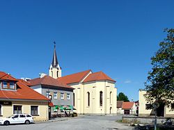 Church of Saint John of Nepomuk | |
 Flag  Coat of arms | |
 Sedlec Location in the Czech Republic | |
| Coordinates: 49°4′22″N 14°17′11″E / 49.07278°N 14.28639°ECoordinates: 49°4′22″N 14°17′11″E / 49.07278°N 14.28639°E | |
| Country | |
| Region | South Bohemian |
| District | České Budějovice |
| First mentioned | 1485 |
| Area | |
| • Total | 20.26 km2 (7.82 sq mi) |
| Elevation | 397 m (1,302 ft) |
| Population (2021-01-01)[1] | |
| • Total | 524 |
| • Density | 26/km2 (67/sq mi) |
| Time zone | UTC+1 (CET) |
| • Summer (DST) | UTC+2 (CEST) |
| Postal code | 373 48 |
| Website | sedlec |

Sedlec is a municipality and village in České Budějovice District in the South Bohemian Region of the Czech Republic. It has about 500 inhabitants. Centres of villages of Malé Chrášťany and Plástovice, which are parts of Sedlec, are uniquely preserved sets of folk baroque buildings and are protected by law as two village monument reservations.
Administrative parts[]

Centre of Plástovice
Villages of Lékařova Lhota, Malé Chrášťany, Plástovice and Vlhlavy are administrative parts of Sedlec.
Geography[]
Sedlec lies approximately 18 kilometres (11 mi) north-west of České Budějovice and 113 km (70 mi) south of Prague.
There are several fish ponds in the municipal territory, the largest of them are Volešek with 134.4 hectares (332 acres)[2] and Vlhlavský with 91.7 hectares (227 acres).[3]
Notable people[]
- Jan Veselý (1923–2003), cyclist
References[]
- ^ "Population of Municipalities – 1 January 2021". Czech Statistical Office. 2021-04-30.
- ^ "Volešek (Plástovský rybník)" (in Czech). Klub českých turistů Tábor. Retrieved 2021-09-01.
- ^ "Vlhlavský rybník" (in Czech). Klub českých turistů Tábor. Retrieved 2021-09-01.
External links[]
| Wikimedia Commons has media related to Sedlec (České Budějovice District). |
| Authority control: National libraries |
|---|
Categories:
- Villages in České Budějovice District