Hosín
Hosín | |
|---|---|
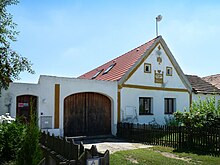
 Centre of Hosín | |
 Flag  Coat of arms | |
 Hosín Location in the Czech Republic | |
| Coordinates: 49°2′15″N 14°28′33″E / 49.03750°N 14.47583°ECoordinates: 49°2′15″N 14°28′33″E / 49.03750°N 14.47583°E | |
| Country | |
| Region | South Bohemian |
| District | České Budějovice |
| First mentioned | 1330 |
| Area | |
| • Total | 30.97 km2 (11.96 sq mi) |
| Elevation | 486 m (1,594 ft) |
| Population (2021-01-01)[1] | |
| • Total | 898 |
| • Density | 29/km2 (75/sq mi) |
| Time zone | UTC+1 (CET) |
| • Summer (DST) | UTC+2 (CEST) |
| Postal code | 373 41 |
| Website | www |

Hosín is a municipality and village in České Budějovice District in the South Bohemian Region of the Czech Republic. It has about 900 inhabitants.
Hosín lies approximately 7 km (4 mi) north of České Budějovice and 117 km (73 mi) south of Prague.
Administrative parts[]

The village of Dobřejovice is an administrative part of Hosín.
History[]
The first written mention of Hosín is from 1330.[2]
Sights[]
The main landmark is the Church of the Saints Peter and Paul. The original was built in the 11th or 12th century. In the 13th century, when this sacral building was no longer sufficient for its spatial capacity, a new, early Gothic church was built, in which the former church was incorporated as a sacristy. In the 1890s, the church was extended and rebuilt into the Neo-Romanesque style.[2]
Other sights include:
- Baroque rectory from the 18th century
- Stone wayside shrine from 1636 along the road towards Hluboká nad Vltavou, with the coat-of-arms of the former estate owner, Baltasar Marradas
- Former china clay mine Orty, a natural monument
- Memorial to those killed in World War I
- Houses built in the Folk Baroque style
References[]
- ^ "Population of Municipalities – 1 January 2021". Czech Statistical Office. 2021-04-30.
- ^ Jump up to: a b "Stručné dějiny obce Hosín" (in Czech). Obec Hosín. Retrieved 2021-08-30.
| Wikimedia Commons has media related to Hosín. |
| show Authority control |
|---|
This South Bohemian Region location article is a stub. You can help Wikipedia by . |
- Villages in České Budějovice District
- South Bohemian Region geography stubs