Davayé
Davayé | |
|---|---|
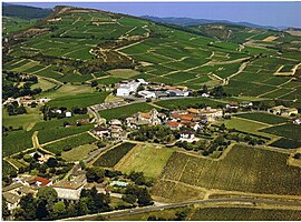 An aerial view of Davayé | |
 Coat of arms | |
show Location of Davayé | |
 Davayé | |
| Coordinates: 46°18′04″N 4°44′40″E / 46.301°N 4.7444°ECoordinates: 46°18′04″N 4°44′40″E / 46.301°N 4.7444°E | |
| Country | France |
| Region | Bourgogne-Franche-Comté |
| Department | Saône-et-Loire |
| Arrondissement | Mâcon |
| Canton | La Chapelle-de-Guinchay |
| Government | |
| • Mayor (2020–2026) | Michel du Roure[1] |
| Area 1 | 4.17 km2 (1.61 sq mi) |
| Population (Jan. 2018)[2] | 697 |
| • Density | 170/km2 (430/sq mi) |
| Time zone | UTC+01:00 (CET) |
| • Summer (DST) | UTC+02:00 (CEST) |
| INSEE/Postal code | 71169 /71960 |
| Elevation | 185–325 m (607–1,066 ft) (avg. 199 m or 653 ft) |
| 1 French Land Register data, which excludes lakes, ponds, glaciers > 1 km2 (0.386 sq mi or 247 acres) and river estuaries. | |


Davayé is a commune in the Saône-et-Loire department in the region of Bourgogne-Franche-Comté in eastern France.
See also[]
References[]
- ^ "Répertoire national des élus: les maires". data.gouv.fr, Plateforme ouverte des données publiques françaises (in French). 2 December 2020. Retrieved 7 December 2020.
- ^ "Populations légales 2018". INSEE. 28 December 2020.
| Wikimedia Commons has media related to Davayé. |
This Saône-et-Loire geographical article is a stub. You can help Wikipedia by . |
Categories:
- Communes of Saône-et-Loire
- Saône-et-Loire geography stubs