Marnay, Saône-et-Loire
show This article may be expanded with text translated from the corresponding article in French. (June 2012) Click [show] for important translation instructions. |
Marnay | |
|---|---|
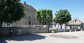 Town hall | |
show Location of Marnay | |
 Marnay | |
| Coordinates: 46°42′09″N 4°55′36″E / 46.7025°N 4.9267°ECoordinates: 46°42′09″N 4°55′36″E / 46.7025°N 4.9267°E | |
| Country | France |
| Region | Bourgogne-Franche-Comté |
| Department | Saône-et-Loire |
| Arrondissement | Chalon-sur-Saône |
| Canton | Saint-Rémy |
| Intercommunality | CA Le Grand Chalon |
| Area 1 | 5.08 km2 (1.96 sq mi) |
| Population (Jan. 2018)[1] | 548 |
| • Density | 110/km2 (280/sq mi) |
| Time zone | UTC+01:00 (CET) |
| • Summer (DST) | UTC+02:00 (CEST) |
| INSEE/Postal code | 71283 /71240 |
| Elevation | 171–180 m (561–591 ft) (avg. 178 m or 584 ft) |
| 1 French Land Register data, which excludes lakes, ponds, glaciers > 1 km2 (0.386 sq mi or 247 acres) and river estuaries. | |


Marnay (French pronunciation: [maʁnɛ]) is a commune in the Saône-et-Loire department in the region of Bourgogne-Franche-Comté in eastern France.[2]
Geography[]
The river Grosne flows into the Saône in the commune.
See also[]
References[]
- ^ "Populations légales 2018". INSEE. 28 December 2020.
- ^ http://www.map-france.com/Marnay-71240/
| Wikimedia Commons has media related to Marnay (Saône-et-Loire). |
This Saône-et-Loire geographical article is a stub. You can help Wikipedia by . |
Categories:
- Communes of Saône-et-Loire
- Saône-et-Loire geography stubs